Image:Nyiragongo and Nyamuragira - PIA03337.jpg
From Wikipedia, the free encyclopedia
Size of this preview: 640 × 297 pixels
Full resolution (670 × 311 pixels, file size: 28 KB, MIME type: image/jpeg)
| |
This is a file from the Wikimedia Commons. The description on its description page there is shown below. |
Summary
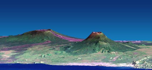
| Description |
Depiction of the Nyiragongo and Nyamuragira volcanoes, based on data from the Shuttle Radar Topography Mission and Landsat. Vertical scale exaggerated (1.5x) |
|---|---|
| Source |
. Further information: . Photo ID: PIA03337 |
| Date |
February 2000 - December 2001 |
| Author |
NASA/JPL/NIMA |
| Permission ( Reusing this image) |
see below |
| Other versions | Image:Nyiragongo and Nyamuragira - PIA03337.png (high resolution) |
| |
This image or video was catalogued by Jet Propulsion Lab of the United States National Aeronautics and Space Administration (NASA) under Photo ID: PIA03337. This tag does not indicate the copyright status or the source of the attached work. A normal copyright tag and a source are still required. See Commons:Licensing for more information. |
Licensing
 |
This file is in the public domain because it was created by NASA. NASA copyright policy states that "NASA material is not protected by copyright unless noted". ( NASA copyright policy page or JPL Image Use Policy). Deutsch | English | Español | Français | Galego | Nederlands | Português | Русский | 中文(简体) | 中文(繁體) | +/- |
|
 |
Warnings:
|
File history
Click on a date/time to view the file as it appeared at that time.
| Date/Time | Dimensions | User | Comment | |
|---|---|---|---|---|
| current | 09:51, 20 December 2007 | 670×311 (28 KB) | Avenue | ({{Information |Description=Depiction of the Nyiragongo and Nyamuragira volcanoes, based on data from the Shuttle Radar Topography Mission and Landsat. |Source=[http://photojournal.jpl.nasa.gov/jpeg/PIA03337.jpg]. Further information: [http://photojournal.) |
File links
The following pages on Schools Wikipedia link to this image (list may be incomplete):