From Wikipedia, the free encyclopedia
 |
This is a file from the Wikimedia Commons. The description on its description page there is shown below.Commons is a freely licensed media file repository. You can help.
|
Description
| Description |
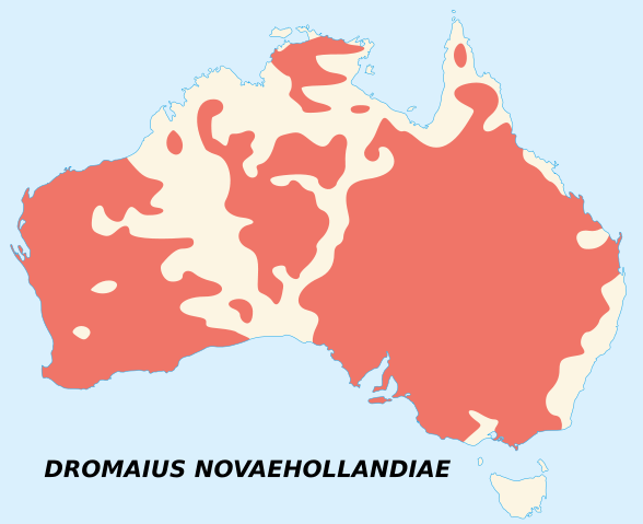
Français : Carte d'observations de l'émeu (Dromaius Novaehollandiae).
English: Emu's recorded observations map (Dromaius Novaehollandiae).
Légende / Legend :
zones où des émeus ont été observés / areas where emu has been recorded. |
| Source |
Français : Œuvre personnelle.
- Fond de carte : NASA Shuttle Radar Topography Mission (SRTM30 v.2) (domaine public).
- Édité avec dlgv32 Pro (version utilisée : 8.01), version gratuite limitée de Global Mapper, logiciel fourni par l'United States Geological Survey (USGS).
- Projection : projection de Mercator.
- Vectorisée et travaillée avec Inkscape.
- Données : Image:Emu distribution.png (données originelles tirées de "The Atlas of Australian Birds, M. Blakers, S. J. J. F. Davies, P. N. Reilly; (1984). Melbourne University Press.")
English: Own work.
- Base map : NASA Shuttle Radar Topography Mission (SRTM30 v.2) (public domain)
- Edited with dlgv32 Pro (version 8.01), free limited version of Global Mapper, software from the United States Geological Survey (USGS)
- Projection : Mercator Projection
- Vectorized and modified with Inkscape.
- Data : Image:Emu distribution.png (original data taken from "The Atlas of Australian Birds, M. Blakers, S. J. J. F. Davies, P. N. Reilly; (1984). Melbourne University Press.")
|
| Date |
2007-06-24 |
| Author |
Sémhur |
Permission
( Reusing this image) |
Voir ci-dessous - See below
|
| Camera location Dromaius novaehollandiae map distribution 2.svg |
27°0′0″S, 135°0′0″E -27;135 |
This and other geocoded Commons images:
|
( Info) |
English: This map was made or improved by the Wikigraphists of the Atelier graphique. You can propose maps or images to clean up and improve as well.
Esperanto: Ĉi tiu mapo estis kreita aŭ plibonigita de la Vikigrafistoj el la Grafika laborgrupo. Vi ankaŭ povas tie proponi mapojn aŭ bildojn plibonigendajn.
Español: Este mapa ha sido confeccionado o mejorado por los Wikígrafos del Taller gráfico. Puedes proponer la mejora de cualquier imagen a través de la página de Peticiones.
Français : Cette carte a été créée ou améliorée par les Wikigraphistes de l' Atelier graphique. Vous pouvez également y proposer des cartes ou des images à améliorer.
Türkçe: Bu harita Atelier graphique'ten Wikigraphistes'ler tarafından yapıldı veya geliştirildi. Siz de haritalar veya resimleri temizlemek veya geliştirmek için teklif edebilirsiniz.
 |
This vector image was created with Inkscape. |
Licensing
I, Sémhur, the copyright holder of this work, has published or hereby publishes it under the following licenses:
 |
Permission is granted to copy, distribute and/or modify this document under the terms of the GNU Free Documentation license, Version 1.2 or any later version published by the Free Software Foundation; with no Invariant Sections, no Front-Cover Texts, and no Back-Cover Texts. A copy of the license is included in the section entitled " GNU Free Documentation license".
Aragonés | العربية | Asturianu | Беларуская (тарашкевіца) | Български | বাংলা | ইমার ঠার/বিষ্ণুপ্রিয়া মণিপুরী | Brezhoneg | Bosanski | Català | Cebuano | Česky | Dansk | Deutsch | Ελληνικά | English | Esperanto | Español | Eesti | Euskara | فارسی | Suomi | Français | Gaeilge | Galego | עברית | Hrvatski | Magyar | Bahasa Indonesia | Ido | Íslenska | Italiano | 日本語 | ქართული | ភាសាខ្មែរ | 한국어 | Kurdî / كوردی | Latina | Lëtzebuergesch | Lietuvių | Bahasa Melayu | Nnapulitano | Nederlands | Norsk (nynorsk) | Norsk (bokmål) | Occitan | Polski | Português | Română | Русский | Slovenčina | Slovenščina | Shqip | Српски / Srpski | Svenska | తెలుగు | ไทย | Tagalog | Türkçe | Українська | اردو | Tiếng Việt | Volapük | Yorùbá | 中文(简体) | 中文(繁體) | +/- |
You may select the license of your choice.
|
File history
Click on a date/time to view the file as it appeared at that time.
|
|
Date/Time |
Dimensions |
User |
Comment |
| current |
15:09, 25 June 2007 |
1,108×903 (114 KB) |
Sémhur |
|
|
|
11:29, 24 June 2007 |
1,108×903 (72 KB) |
Sémhur |
|
File links
The following pages on Schools Wikipedia link to this image (list may be incomplete):