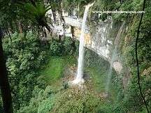
Yumbilla Falls
| Yumbilla Falls | |
|---|---|
.jpg) | |
| Location | Amazonas Region, Peru |
| Type | Tiered |
| Total height | 896 m / 2940 ft |
| Number of drops | 4 |
| World height ranking | 5 |
Yumbilla Falls is the name of a waterfall located near the town of Cuispes, in the northern Peruvian region of Amazonas. It is considered the world's fifth tallest waterfall, becoming internationally known since late 2007 due to a geographical survey conducted by the Geographical Institute of Peru (IGN).[1]
Geography
The top of the waterfall is located at 2723,6 meters above sea level, while the bottom stands at 1828,1 meters above sea level; being 895,5 meters the total height of the waterfall.[1] The height was measured with the help of laser instruments by a geographical survey of the National Geographic Institute of Peru (IGN) in 2007.[1][2] This area is part of the Eastern Peruvian Andes, also known as Cordillera Oriental, more precisely, part of a mountain massif called Cerro Panhuayco.[3]
Yumbilla is considered a tiered type waterfall, since it comprises four or five sections or drops.[1][2][4] The stream is reported to come from a cave named "Caverna San Francisco".[4]
Climate
The reported mean temperature in the area is 22 °C, with a rainy season from December to April.[4]
Ecology
Flora
The area around the waterfall is covered with montane forest vegetation. Bromeliads, orchids (Epidendrum secundum, Fernandezia ionanthera, Oncidium scansor), palms (Ceroxylon parvifrons), Andean alders (Alnus acuminata) and tree ferns (Cyathea spp.) are commonly found in the area.[4]
Fauna
Animals reported in the area include birds like the Andean cock-of-the-rock and the marvellous spatuletail hummingbird; and mammals like the spectacled bear and the yellow-tailed woolly monkey.[4]
Tourism

From Chachapoyas, capital of the Amazonas region, it takes between 75-85 min. (63 km.) to arrive to the town of Cuispes (the road between the towns of Pedro Ruiz and Cuispes is a dirt road). Public transportation to Pedro Ruiz (buses and collective taxis) is available. From Pedro Ruiz to Cuispes (10 km./30 min.), the main public transportation are mototaxis.[4]
From Cuispes, it takes 1-1.5 hours (6 km.) to reach Yumbilla waterfall by foot or on mule. It is advisable to hire a local guide.[4]
The main activities in the area are hiking and wildlife watching.[4]
There are also other waterfalls nearby, the most remarkable being: Pabellón (400 meters high) and Chinata (580 meters high), both within 4 km in a straight line.[1][2]
See also
References
- 1 2 3 4 5 "Yumbilla Falls". Wondermondo.
- 1 2 3 "Yumbilla, Catarata | World Waterfall Database". www.worldwaterfalldatabase.com. Retrieved 2015-12-17.
- ↑ Carta Nacional 1:100000. Jumbilla (12-h). Instituto Geográfico Nacional (IGN).
- 1 2 3 4 5 6 7 8 "Catarata Yumbilla". Inventario Turístico del Perú (in Spanish). MINCETUR. Retrieved 16 December 2015.
External links
| Wikimedia Commons has media related to Yumbilla Falls. |
- http://yumbillawaterfall.wordpress.com/category/yumbilla-waterfall-895m/
- http://www.world-of-waterfalls.com/latin-america-catarata-de-yumbilla.html
- World Waterfall Database
Coordinates: 5°55′11.64″S 77°54′04.32″W / 5.9199000°S 77.9012000°W