Yaowarat Road


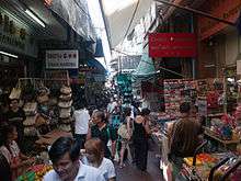
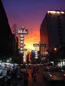
Yaowarat Road (Thai: ถนนเยาวราช]], Chinese: 耀華力路) in Samphanthawong district is the main artery of Bangkok's Chinatown. Modern Chinatown now covers a large area around Yaowarat and Charoen Krung Road. It has been the main centre for trading by the Chinese community since they moved from their old site some 200 years ago to make way for the construction of Wat Phra Kaew, the Grand Palace. Nearby is the Phahurat or Indian market. The area is bordered by the Chao Phraya River to the south. Yaowarat Road is well known for its variety of foodstuffs, and at night turns into a large "food street" that draws tourists and locals from all over the city.
History
Chinatown is in one of the oldest areas of Bangkok. It is the result of the resettlement of Chinese on the west bank of Chao Phraya River after Rama I moved the capital of the kingdom from Thonburi to Rattanakosin. From there Chinese traders operated maritime junk trade between (Siam) and China throughout the Rattanakosin period.[1] By the end of 1891, King Rama V had ordered the construction of many roads, including Yaowarat Road. Chinatown does not consist of only Yaowarat Road, but also includes others such as Charoen Krung Road, Mungkorn Road, Songwat Road, Songsawat Road, and Chakkrawat Road. Yaowarat's Sam Peng Market is the center of the area. The path of the road is said to resemble a dragon's curvy body, making it an auspicious location for business. There are many shops selling gold, garments, textiles, stationery, souvenirs, second-hand parts and equipment, electric goods, computer parts, antiques, imported musical instruments and local delicacies.
Land prices around Yaowarat Road have always been among the most expensive in Bangkok and Thailand due to limited land which is mostly owned by prominent Thai-Chinese families.
References
- ↑ Van Roy, Edward. Sampheng: Bangkok's Chinatown Inside Out. Bangkok: Asian Studies Institute of Chulalongkorn University, 2007
External links
| Wikimedia Commons has media related to Thanon Yaowarat. |
-
 Geographic data related to Yaowarat Road at OpenStreetMap
  Yaowarat and Phahurat travel guide from Wikivoyage
Coordinates: 13°44′28″N 100°30′30″E / 13.741136°N 100.508305°E