Alberta Highway 630
Route map: Google
| ||||
|---|---|---|---|---|
| Highway 630 | ||||
|
Highway 630 highlighted in red | ||||
| Route information | ||||
| Maintained by Alberta Transportation | ||||
| Length: | 40 km[1] (20 mi) | |||
| Major junctions | ||||
| West end: |
| |||
|
| ||||
| South end: |
| |||
| Location | ||||
| Specialized and rural municipalities: | Strathcona County, Beaver County | |||
| Major cities: | Sherwood Park, North Cooking Lake | |||
| Highway system | ||||
|
Provincial highways in Alberta
| ||||

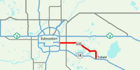
Wye Road is a major arterial road and rural highway that links Sherwood Park from Anthony Henday Drive (Highway 216) on the east side of Edmonton to Highway 14 west of Tofield.[1] It is preceded by Sherwood Park Freeway, and east of Highway 21 is designated as Alberta Provincial Highway No. 630, commonly referred to as Highway 630.[2] Wye Road in Strathcona County, is a historic route from the early 1900s connecting Edmonton to Cooking Lake, parallel to a line of the Canadian National Railway,[3] and it and Highway 630 used to be synonymous for their entire length.[4] In the early 1990s, the portion of Highway 630 east of North Cooking Lake was realigned, resulting in the Highway 630 entering Beaver County and passing through Lindbrook[5] and subsequently paved,[6] while the original gravel route is still designated as Wye Road and links with Highway 14 near Hastings Lake.[7] The portion of Wye Road within Sherwood Park is maintained by Strathcona County and not officially part of Highway 630.[2][8]
Major intersections
Starting from the west end of Wye Road:
References
- 1 2 3 Google (November 11, 2016). "Highway 630 in Alberta" (Map). Google Maps. Google. Retrieved November 11, 2016.
- 1 2 "Provincial Highways 500 - 986 Progress Chart" (PDF). Alberta Transportation. March 2015. Retrieved May 17, 2016.
- ↑ "Mundys map of Edmonton and suburbs". University of Calgary. Mundy Map and Blueprint Company. 1913. Retrieved November 10, 2016.
- ↑ Alberta Tourism (1990). Alberta Official Road Map (Map). Government of Alberta. § I-6.
- ↑ Alberta Tourism (1992). Alberta Official Road Map (Map). Government of Alberta. § I-6.
- ↑ Alberta Economic Development and Tourism (1996). Alberta Official Road Map (Map). Government of Alberta. § I-6.
- ↑ "County Map" (PDF). Strathcona County. March 5, 2013. Retrieved April 24, 2017.
- ↑ "Overall - Road Responsibility" (PDF). Strathcona County. October 17, 2016. Retrieved April 24, 2017.
| North-south streets | |
|---|---|
| East-west streets | |
| Other streets | |
| Freeways and highways | |
| More | |