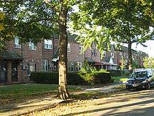
Wyckoff Heights, New York

Wyckoff Heights is an area of New York City along the Brooklyn-Queens border in northwest Bushwick and southwest Ridgewood.
Wyckoff Heights is home to the Wyckoff Heights Medical Center at Wyckoff Avenue and Stockholm Street (originally the German Hospital of Brooklyn, renamed in 1918), and the former Wyckoff Heights Presbyterian Church at Harman Street and St. Nicholas Avenue (founded in 1895[1] and rebuilt after a 1928 fire,[2] now the Ridgewood Pentecostal Church).
The Wyckoff Heights Post Office (zip code 11237) at 86 Wyckoff Avenue was opened in 1951[3] and serves north Bushwick and the Brooklyn portion of Wyckoff Heights.
The area was home first to many German immigrants, later followed by Italian and more recently Latino and Eastern-European residents.
History

Wyckoff Heights was urbanized starting in the late 1800s, and took its name from the Wyckoff family who owned and farmed much of the land.[4] Development progressed from Brooklyn into Queens as portions of the Wyckoff farm were sold.[5][6]
In 1890 the New York Times and New York Tribune announced the creation of a new park (now Maria Hernandez Park) to be located in the Wyckoff Heights section of the 18th Ward of Brooklyn.[7][8]
In 1892 Queens County property owners established the Wyckoff Heights Improvement Association to lobby for water, sewer, and gas service to the neighborhood,[9] and in 1893 the Wyckoff Heights Water Company was formed to supply drinking water to the area.
In 1901 residents of the Queens section lobbied the City government to "adopt a system of house numbering" and erect street signs so that the postal service would begin delivery to the neighborhood.[10] Mail delivery to the Queens section was provided by the Brooklyn Post Office[11] from the early 1900s until 1979, when this and other areas of Queens were granted their own zip code.[12]
The last 18 acres (73,000 m2) of farmland were developed in the 1940s.[13]
Building stock

The first buildings constructed in the neighborhood were largely attached wood frame three- and six-family row houses.
Around the turn of the century, as urbanization moved northeast towards the borough line and into Queens, developers switched to masonry construction in order to conform to new building and fire codes.[14] Many of these buildings are now part of the Cypress Avenue West Historic District.
In the 1940s the last large-scale development in the neighborhood saw the construction of more automobile-oriented attached single-family homes with alleys and garages in the rear.
References

- ↑ Church Cornerstone Laid -- New Building of Wyckoff Heights Chapel Well Underway, Brooklyn Daily Eagle, 1895-10-13
- ↑ Brooklyn Church Burns, New York Evening Post, 1928-01-03, p. 16
- ↑ New Postal Station in Brooklyn, New York Times, 1951-06-17
- ↑ Proclamation Letter (PDF), P.S. 81Q, p. 1, retrieved 2011-10-23
- ↑ Old Philanthropist Dead: Peter Wyckoff Was Millionaire Farmer and Banker of Bushwick, New York Times, 1910-02-10
- ↑ Ambruster, Eugene L. (1912), The Eastern District of Brooklyn, pp. 125–126
- ↑ A New Park for Brooklyn, The New York Times, 1890-10-30
- ↑ Selecting Another New Park, To Be Situated Upon Wyckoff Heights, New York Tribune, 1890-10-30
- ↑ They Want Sewer Connection: Wyckoff Heights Improvement Association Takes Action, Brooklyn Daily Eagle, 1892-01-21
- ↑ Proceeds of the Board of Aldermen of the Municipal Assembly of the City of New York, City of New York, 1901, p. 671
- ↑ Free Delivery Extensions - Mail Carriers for East Williamsburgh, Union Course and Wyckoff Heights, Brooklyn Daily Eagle, 1900-08-30
- ↑ Lee, Jennifer 8. (2007-11-02), Is Ridgewood the New East Bushwick?, =New York Times
- ↑ Builders Acquire Old Queens Farm; $2,000,000 Home Community Is Planned for Final 18 Acres of Wyckoff Holdings, New York Times, 1945-10-14
- ↑ Presa, Donald G (1983), Cypress Avenue West Historic District, New York State Parks and Recreation, Division for Historic Preservation
External links
- Fernandez, Manny (2010-12-10), Of Queens and Kings, New York Times
Coordinates: 40°42′11″N 73°55′08″W / 40.703°N 73.919°W

