Union Station (Worcester, Massachusetts)
Worcester | |||||||||||||||||||||||||||||||||||||||||||||||||||||||
|---|---|---|---|---|---|---|---|---|---|---|---|---|---|---|---|---|---|---|---|---|---|---|---|---|---|---|---|---|---|---|---|---|---|---|---|---|---|---|---|---|---|---|---|---|---|---|---|---|---|---|---|---|---|---|---|
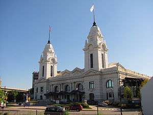
 Union Station in October 2011 | |||||||||||||||||||||||||||||||||||||||||||||||||||||||
| Location |
34 Washington Square Worcester, Massachusetts | ||||||||||||||||||||||||||||||||||||||||||||||||||||||
| Coordinates | 42°15′40″N 71°47′42″W / 42.26111°N 71.79500°WCoordinates: 42°15′40″N 71°47′42″W / 42.26111°N 71.79500°W | ||||||||||||||||||||||||||||||||||||||||||||||||||||||
| Owned by | Worcester Redevelopment Authority | ||||||||||||||||||||||||||||||||||||||||||||||||||||||
| Operated by | MBTA | ||||||||||||||||||||||||||||||||||||||||||||||||||||||
| Line(s) |
Boston and Albany Railroad Worcester Branch Providence and Worcester Railroad Norwich and Worcester Railroad | ||||||||||||||||||||||||||||||||||||||||||||||||||||||
| Platforms | 1 side platform (B&A main) | ||||||||||||||||||||||||||||||||||||||||||||||||||||||
| Tracks |
4 (B&A main) 2 (Worcester Branch) | ||||||||||||||||||||||||||||||||||||||||||||||||||||||
| Bus operators |
| ||||||||||||||||||||||||||||||||||||||||||||||||||||||
| Construction | |||||||||||||||||||||||||||||||||||||||||||||||||||||||
| Parking | 300 short-term spaces | ||||||||||||||||||||||||||||||||||||||||||||||||||||||
| Bicycle facilities | Yes | ||||||||||||||||||||||||||||||||||||||||||||||||||||||
| Disabled access | Yes | ||||||||||||||||||||||||||||||||||||||||||||||||||||||
| Other information | |||||||||||||||||||||||||||||||||||||||||||||||||||||||
| Station code | WOR | ||||||||||||||||||||||||||||||||||||||||||||||||||||||
| History | |||||||||||||||||||||||||||||||||||||||||||||||||||||||
| Opened | 1911 | ||||||||||||||||||||||||||||||||||||||||||||||||||||||
| Rebuilt | 2000 | ||||||||||||||||||||||||||||||||||||||||||||||||||||||
| Traffic | |||||||||||||||||||||||||||||||||||||||||||||||||||||||
| Passengers (FY2016) |
6,152 [1] | ||||||||||||||||||||||||||||||||||||||||||||||||||||||
| Passengers (2013) | 1,475 (weekday inbound average)[2] (MBTA) | ||||||||||||||||||||||||||||||||||||||||||||||||||||||
| Services | |||||||||||||||||||||||||||||||||||||||||||||||||||||||
| |||||||||||||||||||||||||||||||||||||||||||||||||||||||
|
Worcester Union Station | |||||||||||||||||||||||||||||||||||||||||||||||||||||||
| Location | Worcester, Massachusetts | ||||||||||||||||||||||||||||||||||||||||||||||||||||||
| Built by | Woodbury and Leighton Company, Boston[3] | ||||||||||||||||||||||||||||||||||||||||||||||||||||||
| Architect | Watson & Huckel | ||||||||||||||||||||||||||||||||||||||||||||||||||||||
| Architectural style | Beaux Arts | ||||||||||||||||||||||||||||||||||||||||||||||||||||||
| Part of | Blackstone Canal Historic District (#71000030) | ||||||||||||||||||||||||||||||||||||||||||||||||||||||
| NRHP Reference # | 80000617[4] | ||||||||||||||||||||||||||||||||||||||||||||||||||||||
| Significant dates | |||||||||||||||||||||||||||||||||||||||||||||||||||||||
| Added to NRHP | 1980 | ||||||||||||||||||||||||||||||||||||||||||||||||||||||
| Designated CP | August 15, 1995 | ||||||||||||||||||||||||||||||||||||||||||||||||||||||
| Location | |||||||||||||||||||||||||||||||||||||||||||||||||||||||
 Worcester Location within Massachusetts | |||||||||||||||||||||||||||||||||||||||||||||||||||||||
Union Station is located at Washington Square in downtown Worcester, Massachusetts. It is the western terminus of the Massachusetts Bay Transportation Authority's Framingham/Worcester commuter rail line, with inbound service to Boston, and a station along Amtrak's Lake Shore Limited passenger line. It also services Peter Pan, Greyhound, and MAX intercity bus routes, as well as local Worcester Regional Transit Authority (WRTA) bus service.
History

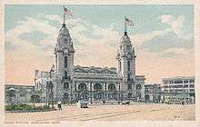
The current station was built in 1911 by the New York Central Railroad along the Boston and Albany Railroad Main Line, during the heyday of railroading in the United States, replacing the previous 1875 station. As a union station, it also served the Providence and Worcester Railroad (which was acquired by the New York, New Haven and Hartford Railroad), the Norwich and Worcester Railroad (acquired by the New York and New England Railroad), the Worcester, Nashua and Rochester Railroad and the Boston, Barre and Gardner Railroad (which both became part of the Boston and Maine Railroad). Passenger service to Union Station ended by 1974, and the abandoned station fell into disrepair.

Subsequently, Union Station was acquired by the Worcester Redevelopment Authority and completely renovated at a cost of $32 million. The station was restored and renovated by Finegold Alexader Architects of Boston, and re-opened in July 2000. [5] An intercity and local bus terminal, with five bus ports, was added at a cost of $5.2 million and opened in August 2006.[6]
Union Station's facilities include the Grand Hall, with original elliptical stained-glass ceilings, interior marble columns and mahogany wood trim, Luciano's Cotton Club, a 1920s gangster-themed restaurant, and the Union Station Parking Garage, which has 500 spaces and direct access to the station.[7] Union Station is wheelchair accessible and has a full length high level platform.
Proposed service
There are proposals to extend more frequent passenger service west to Springfield.[8] The station is the planned northern terminus of the proposed Boston Surface Railroad, a commuter rail line between Worcester and Providence, Rhode Island planned to begin service in 2017.
Bus connections
Greyhound Bus Lines and Peter Pan Bus Lines operate intercity bus service from Worcester along major highways. MAX Express operates intercity bus service between Union Station and Northampton via Fitchburg and Amherst.[9]
WRTA hub
In April 2012, the Worcester Regional Transit Authority broke ground on a new regional transit hub adjacent to historic Union Station:
When completed, the new 14,000 square foot facility will house the WRTA’s administrative offices and its customer service center. Included in the design are a new bus pavilion with an enclosed public waiting area, restroom facilities, ticket vending machines and eight bus slips.[10]
The cost was $14 million, with $10 million coming from the Federal Government and the rest coming from the state.[10][11] The new hub opened in May, 2013.[12]
References
- ↑ "Amtrak Fact Sheet, Fiscal Year 2016, State of Massachusetts" (PDF). Amtrak. December 1, 2015. Retrieved 16 February 2017.
- ↑ "Ridership and Service Statistics" (PDF) (14 ed.). Massachusetts Bay Transportation Authority. 2014. Retrieved 24 December 2015.
- ↑ "Present Condition of Union Station". The Worcester Magazine. Worcester Massachusetts: Worcester Board of Trade. August 1910. Retrieved 16 May 2017.
- ↑ Worcester County Listings at the National Register of Historic Places
- ↑ http://faainc.com/projects/union-station-intermodal-transportation/
- ↑ Worcester, MA - Union Station/Washington Square Project Archived February 4, 2005, at the Wayback Machine.
- ↑ "Archived copy". Archived from the original on June 14, 2009. Retrieved June 23, 2009.
- ↑ "Amtrak Fact Sheet, FY2014, Commonwealth of Massachusetts" (PDF). Amtrak. November 2014. Retrieved 29 November 2015.
- ↑ "MAX Service Schedules". TrueNorth Transit Group. Retrieved 23 December 2015.
- 1 2 "Groundbreaking Ceremony for WRTA Transportation Hub". Worcester Regional Transit Authority Homepage. Worcester Regional Transit Authority. Retrieved 16 April 2012.
- ↑ Bock, Linda (April 4, 2012). "New WRTA hub, maintenance garage in the wind". Worcester Telegram & Gazette. Retrieved 16 April 2012.
- ↑ http://www.therta.com/about/new-hub-construction/ WRTA, Transportation Hub
External links
![]() Media related to Union Station (Worcester, Massachusetts) at Wikimedia Commons
Media related to Union Station (Worcester, Massachusetts) at Wikimedia Commons
- Amtrak – Stations – Worcester, MA
- MBTA - Worcester Union Station
- Worcester Union Station, Great American Stations
- Union Station/Washington Square Project
- Worcester Union Station (USA RailGuide — TrainWeb)
- Station Building from Google Maps Street View
- Station from I-290 from Google Maps Street View
