Woonsocket, Rhode Island
| City of Woonsocket | |
|---|---|
| City | |
|
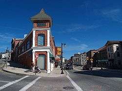
Downtown Woonsocket | |
| Motto: "A City on the Move" | |
 Location in Providence County and the state of Rhode Island. | |
| Coordinates: 42°00′30″N 71°30′58″W / 42.00833°N 71.51611°WCoordinates: 42°00′30″N 71°30′58″W / 42.00833°N 71.51611°W | |
| Country | United States |
| State | Rhode Island |
| County | Providence |
| Incorporated (town) | 1867 |
| Incorporated (city) | 1888 |
| Government | |
| • Type | Mayor-council |
| • Mayor | Lisa Baldelli-Hunt |
| Area | |
| • Total | 7.96 sq mi (20.62 km2) |
| • Land | 7.7 sq mi (20.0 km2) |
| • Water | 0.2 sq mi (0.6 km2) |
| Elevation | 184 ft (56 m) |
| Population (2010) | |
| • Total | 41,186 |
| • Density | 5,348.8/sq mi (2,059.3/km2) |
| Time zone | Eastern (UTC-5) |
| • Summer (DST) | Eastern (UTC-4) |
| ZIP code | 02895 |
| Area code(s) | 401 |
| FIPS code | 44-80780[1] |
| GNIS feature ID | 1219339[2] |
| Website | |
Woonsocket (/wʌnˈsɒkɪt/ one-SOCK-it) is a city in Providence County, Rhode Island, United States. The population was 41,186 at the 2010 census, making it the sixth largest city in the state. Woonsocket lies directly south of the Massachusetts state line.
The city is the corporate headquarters of CVS Health, a pharmacy services provider. It is home to Landmark Medical Center, the Museum of Work and Culture and the American-French Genealogical Society.[3]
History
Before the arrival of European settlers in northern Rhode Island during the 17th century, today's Woonsocket region was inhabited by three Native American tribes—the Nipmucs (Cowesett), Wampanoags, and Narragansetts.[4] In 1661, the English theologian Roger Williams purchased the area from the "Coweset and Nipmucks", and in a letter referred to modern day Woonsocket as "Niswosakit".[5]
Other possible derivations to the name include several Nipmuc geographic names from nearby Massachusetts. These include Woonksechocksett, from Worcester County meaning "fox country", and Wannashowatuckqut, also from Worcester County, meaning "at the fork of the river".[6] Another theory states Woonsocket derives from "thunder mist", in reference to the largest waterfall on the Blackstone River, which lies at the center of the city. Yet another theory proposes that the city was named after Woonsocket Hill in neighboring North Smithfield.
Woonsocket Falls Village was founded in the 1820s. Its fortunes expanded as the Industrial Revolution took root in nearby Pawtucket. With the Blackstone River providing ample water power, the region became a prime location for textile mills. Woonsocket as a town was not established until 1867 when three villages in the town of Cumberland, namely Woonsocket Falls, Social and Jenckesville, officially became the town of Woonsocket. By this time the beginnings of the French Canadian emigration had definitely been felt.
In 1871, three additional industrial villages[7] in Smithfield, Hamlet, Bernon and Globe, were added to the town establishing its present boundaries. Woonsocket was incorporated as city in 1888.
During the Great Depression the local textile industry closed, causing high unemployment. At this point 75 percent of the population was of French-Canadian descent. French-language newspapers were published and sold here, and radio programs and movies shown were also in French. Most conversations in public were also in French.[8] The city's fortunes were revived in World War II, when it became a center of fabric manufacturing for the war effort. In the postwar years, the Woonsocket economy adjusted to a mix of manufacturing, retail, technology and financial services operations.[7] However, in the early 1980s Woonsocket was again plagued by high unemployment rates.[9] In 1980 seventy percent of Woonsocket's population was French-Canadian descent.[9]
Beginning in 1979, Woonsocket became home to Autumnfest, an annual cultural festival that takes place on Columbus Day Weekend, at World War II Veteran's Memorial State Park. It has become one of the city's most popular events.[10]
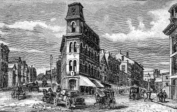
 Woonsocket from the East, 1886 engraving
 Woonsocket Medical Corporation, founded in 1839 by Dr. Seth Arnold
 Woonsocket in 1855
 1886 engraving
Geography
According to the United States Census Bureau, the city has a total area of 8.0 square miles (21 km2), of which 7.7 square miles (20 km2) is land and 0.3 square miles (0.78 km2) (3.14%) is water. Woonsocket is drained by the Blackstone River. Adjacent communities include Blackstone and Bellingham, Massachusetts, along with Cumberland and North Smithfield, Rhode Island.
Climate
Woonsocket has a strong humid continental climate with four distinct-seasons.
| Climate data for Woonsocket, Rhode Island | |||||||||||||
|---|---|---|---|---|---|---|---|---|---|---|---|---|---|
| Month | Jan | Feb | Mar | Apr | May | Jun | Jul | Aug | Sep | Oct | Nov | Dec | Year |
| Record high °F (°C) | 68 (20) |
70 (21) |
87 (31) |
94 (34) |
97 (36) |
102 (39) |
102 (39) |
104 (40) |
96 (36) |
90 (32) |
82 (28) |
76 (24) |
104 (40) |
| Average high °F (°C) | 37 (3) |
40 (4) |
49 (9) |
59 (15) |
70 (21) |
79 (26) |
84 (29) |
82 (28) |
75 (24) |
64 (18) |
53 (12) |
42 (6) |
61 (16) |
| Average low °F (°C) | 13 (−11) |
16 (−9) |
25 (−4) |
35 (2) |
45 (7) |
55 (13) |
60 (16) |
59 (15) |
49 (9) |
37 (3) |
30 (−1) |
20 (−7) |
37 (3) |
| Record low °F (°C) | −25 (−32) |
−20 (−29) |
−13 (−25) |
11 (−12) |
25 (−4) |
31 (−1) |
38 (3) |
30 (−1) |
23 (−5) |
15 (−9) |
−2 (−19) |
−16 (−27) |
−25 (−32) |
| Average precipitation inches (mm) | 4.52 (114.8) |
3.40 (86.4) |
4.11 (104.4) |
4.22 (107.2) |
3.59 (91.2) |
3.83 (97.3) |
3.65 (92.7) |
4.20 (106.7) |
4.12 (104.6) |
4.26 (108.2) |
4.60 (116.8) |
4.05 (102.9) |
48.55 (1,233.2) |
| Average snowfall inches (cm) | 11.3 (28.7) |
12.5 (31.8) |
7.4 (18.8) |
1.5 (3.8) |
0.2 (0.5) |
0 (0) |
0 (0) |
0 (0) |
0 (0) |
0 (0) |
1.7 (4.3) |
8.2 (20.8) |
42.8 (108.7) |
| Source #1: [11] | |||||||||||||
| Source #2: [12] | |||||||||||||
Demographics
| Historical population | |||
|---|---|---|---|
| Census | Pop. | %± | |
| 1870 | 11,527 | — | |
| 1880 | 16,050 | 39.2% | |
| 1890 | 20,830 | 29.8% | |
| 1900 | 28,204 | 35.4% | |
| 1910 | 38,126 | 35.2% | |
| 1920 | 43,496 | 14.1% | |
| 1930 | 49,376 | 13.5% | |
| 1940 | 49,303 | −0.1% | |
| 1950 | 50,211 | 1.8% | |
| 1960 | 47,080 | −6.2% | |
| 1970 | 46,820 | −0.6% | |
| 1980 | 45,914 | −1.9% | |
| 1990 | 43,877 | −4.4% | |
| 2000 | 43,224 | −1.5% | |
| 2010 | 41,186 | −4.7% | |
| Est. 2016 | 41,406 | [13] | 0.5% |
At the 2010 census Woonsocket had a population of 41,186. The population was 71.3% non-Hispanic white, 14.2% Hispanic or Latino, 6.4% African American, 5.4% Asian, 0.4% Native American and 4.3% reporting two or more races.[15]
At the census[1] of 2000, there were 43,224 people, 17,750 households, and 10,774 families residing in the city. The population density was 5,608.8 people per square mile (2,164.6/km²). There were 18,757 housing units at an average density of 2,433.9 per square mile (939.3/km²). The racial makeup of the city was 83.14% White, 4.44% African American, 0.32% Native American, 4.06% Asian, 0.03% Pacific Islander, 4.86% from other races, and 3.14% from two or more races. Hispanic or Latino of any race were 9.32% of the population.
Woonsocket is a part of the Providence metropolitan area, which has an estimated population of 1,622,520.
There were 17,750 households out of which 31.2% had children under the age of 18 living with them, 39.4% were married couples living together, 16.2% had a female householder with no husband present, and 39.3% were non-families. 32.7% of all households were made up of individuals and 12.5% had someone living alone who was 65 years of age or older. The average household size was 2.37 and the average family size was 3.02.
In the city, the population was spread out with 25.8% under the age of 18, 9.2% from 18 to 24, 30.0% from 25 to 44, 19.7% from 45 to 64, and 15.2% who were 65 years of age or older. The median age was 35 years. For every 100 females there were 91.2 males. For every 100 females age 18 and over, there were 86.8 males.
The median income for a household in the city was $30,819, and the median income for a family was $38,353. Males had a median income of $31,465 versus $24,638 for females. The per capita income for the city was $16,223. About 16.7% of families and 19.4% of the population were below the poverty line, including 31.3% of those under age 18 and 14.7% of those age 65 or over. In March 2013, the Washington Post reported that one-third of Woonsocket’s population used food stamps, putting local merchants on a "boom or bust" cycle each month when EBT payments were deposited.[16]
At the 2000 census, 46.1% of Woonsocket’s population were identified as being of French or French-Canadian ethnic heritage. The city has referred to itself as La ville la plus française aux États-Unis—the most French city in the United States.[17]
Historic places
Properties and districts in Woonsocket listed on National Register of Historic Places:
- 1761 Milestone
- Allen Street Historic District
- Alphonse Gaulin Jr. House (1885)
- Bernon Worsted Mill (1919)
- Cato Hill Historic District
- Frank Wilbur House (1923)
- Glenark Mills (1865)
- Grove Street Elementary School (1876)
- Hanora Mills (1827)
- Harris Warehouse (1855)
- Henry Darling House (1865)
- Honan's Block and 112-114 Main Street (1879)
- Hope Street School (1899)
- Island Place Historic District
- Jenckes Mansion (1828)
- John Arnold House (1712)
- L'Eglise du Precieux Sang (1873)
- Linton Block (1888)
- Logee House (1729)
- Main Street Historic District
- North End Historic District
- Philmont Worsted Company Mill (1919)
- Pothier House (1881)
- Smith-Ballou House (1906)
- Smithfield Friends Meeting House, Parsonage and Cemetery (1719/1881)
- South Main Street Historic District
- St. Andrews Episcopal Chapel (1894)
- St. Ann's Church Complex (1913)
- St. Charles Borromeo Church Complex (1867)
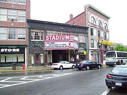
- Stadium Building (1925)
- Union Village Historic District
- Woonsocket City Hall (1856)
- Woonsocket Civil War Monument (1868)
- Woonsocket Company Mill Complex
- Woonsocket Depot Square (1847)
- Woonsocket District Courthouse (1894)
- Woonsocket Rubber Company Mill (1857)
Filming location
Woonsocket was a filming location for the movies, such as the popular Hachi: A Dog's Tale (2009) and The Purge: Election Year (2016).
Notable people

- Greg Abate, musician
- Norm Abram, master carpenter, TV host/personality
- Jonathan Earle Arnold, politician
- Rocco Baldelli, baseball player
- Latimer Whipple Ballou, congressman
- Bryan Berard, hockey player
- Brian Boucher, hockey player
- Percy Daniels, populist politician
- Marcel Desaulniers, chef
- Eddie Dowling, actor, screenwriter and songwriter
- Allen Doyle, golfer
- Draco and the Malfoys, wizard rock band
- Denise Duhamel, poet
- Susan Eisenberg, voice artist
- Eileen Farrell, opera soprano
- Marie Rose Ferron, world-famous stigmatist
- Ernest Fortin, theology professor
- Stuart Gitlow, physician
- Gabby Hartnett, baseball player and manager
- Michelle Holzapfel, woodworking artist
- Ambrose Kennedy, congressman
- Clem Labine, baseball player
- Nap Lajoie, baseball player
- Neil Lanctot, historian and author
- Francis Leo Lawrence, college president
- William C. Lovering, congressman
- James McAndrews, congressman
- J. Howard McGrath, politician
- Dave McKenna, jazz pianist
- Isabelle Ahearn O'Neill, Rhode Island's first woman legislator
- Edwin O'Connor, radio personality and novelist
- Aram J. Pothier, governor
- Duke Robillard, blues guitarist
- Christopher Robinson, congressman
- Mathieu Schneider, hockey player
- Bill Summers, umpire
See also
References
- 1 2 "American FactFinder". United States Census Bureau. Archived from the original on 2013-09-11. Retrieved 2008-01-31.
- ↑ "US Board on Geographic Names". United States Geological Survey. 2007-10-25. Retrieved 2008-01-31.
- ↑ "About Woonsocket". City of Woonsocket. Retrieved January 27, 2009.
- ↑ Woonsocket, Rhode Island – My Home Town – History
- ↑ Walter Nebiker, The History of North Smithfield (New England History Press: Somersworth, NH: 1976), 12–13.
- ↑ "Nipmuc place names of New England". native tach.org. Retrieved April 12, 2008.
- 1 2 Erik Eclison. "Growth of an Industrial City". Woonsocket: My Hometown on the Web. Retrieved January 27, 2009.
- ↑ Pierre Anctil, "Franco-American in New England" in Dean R. Louder and Eric Waddell, ed., and Franklin Philip, tran. French America: Mobility, Identity and Monority Experience Across the Continent (Baton Rouge: Louisiana State University Press, 1993), p. 40
- 1 2 Anctil, "Franco-Americans in New England", p. 41
- ↑ Philip Marcelo (October 9, 2007). "Woonsocket’s Autumnfest draws thousands". Providence Journal. Retrieved January 28, 2009.
- ↑ http://www.intellicast.com/Local/History.aspx?location=USRI0069
- ↑ "Weatherbase: Historical Weather for Woonsocket, Rhode Island". Weatherbase. 2011. Retrieved on November 24, 2011.
- ↑ "Population and Housing Unit Estimates". Retrieved June 9, 2017.
- ↑ "Census of Population and Housing". Census.gov. Archived from the original on May 12, 2015. Retrieved June 4, 2015.
- ↑ Census Quick facts for Woonsocket
- ↑ "Food stamps put Rhode Island town on monthly boom-and-bust cycle". The Washington Post. 2013-03-16. Retrieved 2013-04-14.
- ↑ Dani Safford (September 13, 2008). "Woonsocket’s Autumnfest draws thousands". The Woonsocket Call. Archived from the original on September 20, 2008. Retrieved January 28, 2009.
External links
| Wikimedia Commons has media related to Woonsocket, Rhode Island. |
| Wikivoyage has a travel guide for Woonsocket. |
| Wikisource has the text of the 1921 Collier's Encyclopedia article Woonsocket. |


