Willimantic, Connecticut
| Willimantic, Connecticut | ||||||||
|---|---|---|---|---|---|---|---|---|
| Census-designated place | ||||||||
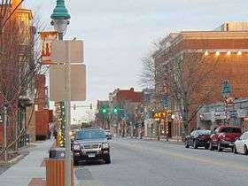
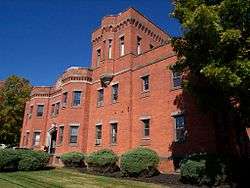
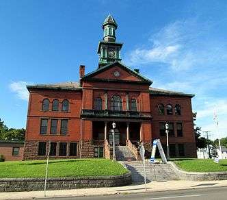
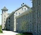
From top to bottom, left to right: The view of the center of Willimantic from Route 66, the Willimantic Footbridge, a well known bridge, a railroad yard, the Willimantic Armory, the Windham Town Hall, and the American Thread Company's former mill | ||||||||
| ||||||||
| Nickname(s): Thread City, Frog City | ||||||||
 Location in Windham County and Connecticut | ||||||||
| Coordinates: 41°43′N 72°13′W / 41.717°N 72.217°WCoordinates: 41°43′N 72°13′W / 41.717°N 72.217°W | ||||||||
| County | Windham County | |||||||
| Government | ||||||||
| • Mayor | Ernest S. Eldridge (Independent) | |||||||
| Area | ||||||||
| • Census-designated place | 11.6 km2 (4.5 sq mi) | |||||||
| • Land | 11.4 km2 (4.4 sq mi) | |||||||
| • Water | 0.3 km2 (0.1 sq mi) | |||||||
| Population (2010) | ||||||||
| • Census-designated place | 17,737 | |||||||
| • Density | 1,391/km2 (3,600/sq mi) | |||||||
| • Urban | 29,669 | |||||||
| Time zone | Eastern (UTC-5) | |||||||
| • Summer (DST) | Eastern (UTC-4) | |||||||
| Website | Official website | |||||||


Willimantic is a census-designated place, former city and borough, and special-services district. It is located in the town of Windham in Windham County, Connecticut. The population was 17,737 at the 2010 census. It is home to Eastern Connecticut State University and the Windham Textile and History Museum. Willimantic was incorporated as a city in 1893; the city was superseded in 1983 by the Willimantic Special Services District/Willimantic CDP. It is also the birthplace of former U.S. Senator Christopher Dodd of Connecticut.
History
Name
Willimantic is an Algonquian term for "land of the swift running water".
Early history
Prior to 1821, the village was known as Willimantic Falls, home to about twenty families and a single school district. In 1822, Charles Lee erected a factory on Main Street made of stone quarried from the Willimantic River. Although small shops and manufacturers had been built on the banks of the Willimantic before, this was the beginning of industrialized Willimantic. In 1825, the three Jillson brothers built a factory along the Willimantic River, and in 1827, they built a second building. By 1828, there were six cotton factories in Willimantic, all built within a seven-year span. Willimantic became known as "Thread City" because American Thread Company had a mill on the banks of the Willimantic River, and was at one time the largest employer in the state as well as one of the largest producers of thread in the world. Its factory was the first in the world to use electric lighting.[1] In 1833, Willimantic was a borough of Windham;[2] in 1893, it would become a city.[3]
City history
From the end of the Civil War to the outbreak of World War II, Willimantic was a center for the production of silk and cotton thread. Immigrants from Europe arrived to work in the mills—Irish, Italians, Poles, Germans and French Canadians. Later, Estonian, Ukrainian, Latvian, Lithuanian, and Puerto Rican immigrants moved to the town in search of mill jobs.
Railroads added to the growth of Willimantic; the town was one of only a handful of stops between Boston and New York on the high-speed "White Train" of the 1890s.[4] In the early 20th century, between 50 and 100 trains ran through Willimantic daily.[5] More than 800 ornate Victorian homes multiplied in the town's Prospect Hill section, which is now listed on the National Register of Historic Places. The town prospered, growing from a population of less than 5,000 in 1860 to more than 12,100 by 1910.[6]
Later history
But hard times followed; American Thread moved to North Carolina in 1985[7] and without it, the town's economy floundered. In 1983, the city and the town consolidated and became one town again. The unemployment rate in Windham, the town that contains Willimantic, was 7.8% as of December 2014.[8] In 2002, The Hartford Courant ran an investigative series called "Heroin Town" describing rampant heroin use in Willimantic, disproportionate to the town's small size. The articles roiled local residents; a task force was appointed by the state to study the issue.[9] In addition, The Hotel Hooker, once known for drug use and prostitution, has been repurposed as a transitional living facility called the Seth Chauncy Hotel.[10] The hotel was later renamed Windham House, and now has been closed.[11]
Today, several projects aiming to revitalize the town are underway. The Willimantic Whitewater Partnership[12] plans to reclaim the town's riverfront by developing a whitewater park and research facility. Some of the town's distressed factory buildings have been turned into residential space for artists by Artspace.[13] Efforts to attract high-tech businesses to the area have turned other former factory buildings into space for small technology startups.[14]
Gallery
 Bird's-eye view in 1908
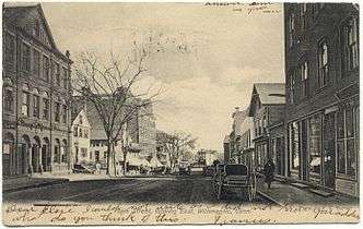 Main Street c. 1906
 Mill No. 1 c. 1912
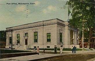 Post Office c. 1913
Geography
According to the United States Census Bureau, the CDP has a total area of 4.5 square miles (12 km2). 4.4 square miles (11 km2) of it is land and 0.1 square miles (0.26 km2) of it (2.23%) is water. Willimantic is drained by the Willimantic River.[15]
Climate
| Month | Jan | Feb | Mar | Apr | May | Jun | Jul | Aug | Sep | Oct | Nov | Dec | Year |
|---|---|---|---|---|---|---|---|---|---|---|---|---|---|
| Record high °F (°C) | 69 (21) |
72 (22) |
82 (28) |
93 (34) |
95 (35) |
98 (37) |
100 (38) |
100 (38) |
100 (38) |
88 (31) |
80 (27) |
75 (24) |
100 (38) |
| Average high °F (°C) | 35.3 (1.8) |
38.4 (3.6) |
47.3 (8.5) |
59.3 (15.2) |
70.1 (21.2) |
78.0 (25.6) |
82.3 (27.9) |
80.8 (27.1) |
73.8 (23.2) |
62.1 (16.7) |
51.9 (11.1) |
40.3 (4.6) |
59.97 (15.54) |
| Daily mean °F (°C) | 29.0 (−1.7) |
31.7 (−0.2) |
38.3 (3.5) |
48.1 (8.9) |
57.9 (14.4) |
67.7 (19.8) |
73.4 (23) |
72.1 (22.3) |
64.9 (18.3) |
54.0 (12.2) |
44.7 (7.1) |
34.7 (1.5) |
51.38 (10.76) |
| Average low °F (°C) | 17.0 (−8.3) |
19.6 (−6.9) |
26.3 (−3.2) |
36.2 (2.3) |
45.9 (7.7) |
55.5 (13.1) |
61.0 (16.1) |
59.9 (15.5) |
51.4 (10.8) |
39.6 (4.2) |
31.4 (−0.3) |
22.3 (−5.4) |
38.84 (3.8) |
| Record low °F (°C) | −27 (−33) |
−21 (−29) |
−16 (−27) |
6 (−14) |
22 (−6) |
30 (−1) |
37 (3) |
32 (0) |
20 (−7) |
15 (−9) |
1 (−17) |
−18 (−28) |
−27 (−33) |
| Average precipitation inches (mm) | 3.36 (85.3) |
3.25 (82.6) |
4.32 (109.7) |
3.74 (95) |
3.49 (88.6) |
3.68 (93.5) |
3.43 (87.1) |
3.35 (85.1) |
3.44 (87.4) |
3.94 (100.1) |
3.99 (101.3) |
3.78 (96) |
43.77 (1,111.7) |
| Average snowfall inches (cm) | 8.1 (20.6) |
11.1 (28.2) |
5.5 (14) |
1.1 (2.8) |
0.0 (0) |
0.0 (0) |
0.0 (0) |
0.0 (0) |
0.0 (0) |
0.0 (0) |
0.9 (2.3) |
6.7 (17) |
33.4 (84.9) |
| Average precipitation days (≥ 0.1 in) | 6 | 6 | 7 | 7 | 8 | 7 | 6 | 5 | 6 | 6 | 6 | 7 | 72 |
| Average snowy days (≥ 0.1 in.) | 4 | 4 | 3 | 0 | 0 | 0 | 0 | 0 | 0 | 0 | 1 | 2 | 15 |
| Source: [16] [17] | |||||||||||||
Demographics
| Historical population | |||
|---|---|---|---|
| Census | Pop. | %± | |
| 1880 | 6,608 | — | |
| 1890 | 8,648 | 30.9% | |
| 1900 | 8,937 | 3.3% | |
| 1910 | 11,230 | 25.7% | |
| 1920 | 12,330 | 9.8% | |
| 1930 | 12,102 | −1.8% | |
| 1940 | 12,101 | 0.0% | |
| 1950 | 13,586 | 12.3% | |
| 1960 | 13,881 | 2.2% | |
| 1970 | 14,402 | 3.8% | |
| 1980 | 14,652 | 1.7% | |
| 1990 | 14,746 | 0.6% | |
| 2000 | 15,823 | 7.3% | |
| 2010 | 17,737 | 12.1% | |
| Est. 2015 | 17,411 | −1.8% | |
| U.S. Decennial Census / Social Explorer Map | |||
As of the 2000 US Census,[18] there were 15,823 people, 5,604 households, and 3,166 families residing in the CDP. The population density was 3,607.0 inhabitants per square mile (1,391.6/km²). There were 6,026 housing units at an average density of 1,373.7 per square mile (530.0/km²). The racial makeup of the CDP was 70.35% White, 6.25% African American, 0.59% Native American, 1.67% Asian, 0.13% Pacific Islander, 16.87% from other races, and 4.13% from two or more races. Hispanic or Latino of any race were 30.19% of the population.
There were 5,604 households out of which 29.7% had children under the age of 18 living with them, 33.5% were married couples living together, 18.1% had a female householder with no husband present, and 43.5% were non-families. 33.2% of all households were made up of individuals and 12.7% had someone living alone who was 65 years of age or older. The average household size was 2.45 and the average family size was 3.13.
In the CDP the population was spread out with 22.6% under the age of 18, 22.4% from 18 to 24, 27.3% from 25 to 44, 16.1% from 45 to 64, and 11.5% who were 65 years of age or older. The median age was 28 years. For every 100 females there were 95.0 males. For every 100 females age 18 and over, there were 91.6 males.
The median income for a household in the CDP was $30,155, and the median income for a family was $38,427. Males had a median income of $30,697 versus $23,297 for females. The per capita income for the CDP was $15,727. About 14.6% of families and 19.8% of the population were below the poverty line, including 25.7% of those under age 18 and 12.6% of those age 65 or over.
Willimantic's largest private employer is Willimantic Waste Paper Company, which specializes in the collection and recycling of fiber products, scrap metal, and co-mingled plastic refuse. Brand-Rex Corporation also maintains a major cable manufacturing facility in Willimantic, which manufactures specialty wire and cable for commercial and industrial customers.
The urban area is a small area surrounding the CDP, which has a current population of 29,669 at the 2010 census.[19]
Notable areas

Notable places
- Willimantic Food Co-op:[20] Willimantic is home to the only store front food cooperative in the state. The Willimantic Food Co-op was born of a large buyers' club and opened on Main Street in 1980. Ten years later it moved to a larger space a few blocks away at 27 Meadow Street, and most store items were moved via a human chain of Co-op members. After fifteen more years it moved to an even bigger location at 91 Valley Street where it is now. The Co-op hosts the Downtown Country Fair every autumn with a farmer's market, live music, food, crafts and children's activities.
- Willimantic Footbridge: Willimantic is the home of the Willimantic Footbridge (established in 1907), which is the only footbridge in the United States to connect two state highways, as well as crossing all three major forms of transportation (road, rail, and river).
- Prospect Hill Historic District: One of the largest National Register-listed historic districts in the state in terms of number of buildings, of which it has 993, a remarkable 88% contribute to its overall historic architectural character.
- Thread City Bread: Willimantic had its own local currency called "Thread City Bread". The currency was valid tender at a number of local businesses.[21]
- Thread City Crossing ("The Frog Bridge"):[22] Architecturally designed bridge, officially opened in June 2001. The landmark is adorned with eight foot high bronze frogs atop concrete thread spools, designed by Leo Jensen. The spools on the bridge represent Willimantic’s prominence in cotton thread and silk manufacturing. The frogs represent the legendary Windham Frog Fight of 1754.[23]
- The Garden on the Bridge:[24] The narrow stone arch bridge was built in 1857 by Lyman Jordan and Nathaniel Olin. In 1857 the new stone arch cost $3,200 to build and was paid for by the Willimantic Linen Co. (Willimantic Thread) and an eight percent tax hike on the town’s richest citizens. In 1907 the townspeople wanted to widen the bridge, but this idea was rejected in favor of planning for a new bridge. Ninety years later the "Thread City Crossing" Bridge was dedicated, thus resulting in the October 22, 2006 dedication of the Windham Garden on the Bridge.[25] On June 2, 2007, the Windham Garden on the Bridge was dedicated to Virginia Darrow, founding president of the Garden Club of Windham. The Gardens are maintained by volunteers of the Windham Garden Club and Public Works employees.
- The Connecticut Eastern Railroad Museum is located off Bridge Street in downtown Willimantic, Connecticut, on the original site of the Columbia Junction Freight Yard. The collection includes locomotives and rolling stock, as well as vintage railroad buildings and a six-stall roundhouse reconstructed on the original foundation.[26]
- The former post office now holds the Willimantic Brewing Company, a local pub.[27]
Notable events
- Willimantic Boom Box Parade:[28] Willimantic has received national and international attention for its annual Boom Box Parade. Back in 1986, with the local Windham High School marching Band having disbanded, local parade fan Kathleen Clark approached the local radio station WILI with the idea of a people’s parade. She offered her collection of vintage marching music records to the radio station with her idea that they play these patriotic marches throughout the duration of the parade. Parade goers were encouraged to bring their Boom Box radios and tune into 1400 AM. The parade was a hit, and its unique notion of having no live music has drawn the attention of CBS Evening News and the Washington Post,[29] among others. The parade Grand Marshal is WILI radio host and local celebrity Wayne Norman. Parade participation is equally as important as parade attendance, with the vast majority of parade participants being individual citizens or local citizens groups who simply wish to share their creativity and national pride with spectators. Other cities from Madison, WI and Lubbock, TX, to Newfane, NY and Bullhead City, AZ, have had Boom Box Parades, but none have endured or been as large as Willimantic's.[30]
- 3rd Thursday Street Fests:[31] Every third Thursday from May to September, Willimantic Renaissance, Inc. hosts on Main Street a festival of musical, theatrical, visual and olfactory delights. Six stages simultaneously host a wide variety of music and entertainment for audiences of all ages. People sample authentic ethnic international cooking and local micro-brewed beer or soda. The streets are filled with around 100 vendors and crafters, street performers and children's activities. 3rd Thursday Street Fest is a community event, completely organized by volunteers and with no paid staff. The event began in 2002 and draws about 8,000 attendees.[32]
- Victorian Days in Willimantic:[33] produced by the Willimantic Victorian Neighborhood Association, are the first weekend in June and feature Home Tours, Victorian Teas, Trolley Tours, Art Shows, Museums, Concerts and special events.
- Romantic Willimantic: Willimantic celebrates Valentine's Day as "Romantic Willimantic". Al Saba was proclaimed Mr. Romantic Willimantic in 1981. Each year since, a local civic leader or citizen is crowned as Willimantic’s "Cupid" for their contributions to the city. The "Romantic Willimantic Chocolate Fest" is held on the weekend of or following Valentine's Day, and features a vaudeville show, Chocolate Chip Stroll on historic Main Street, restaurants featuring chocolate foods (mole, martinis, pancakes, beer,etc.), and a chocolate cake baking contest.
Infrastructure
Education
Public schools
- Windham High School
- Windham Middle School
- Windham Technical High School
- Arts at the Capitol Theater Performing Arts High School
- Charles H. Barrows STEM fields Academy
- Natchaug School
- W.B. Sweeney School
- St. Mary-St. Joseph School
Post-secondary education
Transportation
Road
The borough is served by several state routes: Route 14, Route 32, Route 66, Route 195, and Route 289. The borough is also served by the Willimantic Bypass (US 6).
Bus
The Windham Region Transit District manages public transport, including buses. It has connections to Hartford or Danielson.
Media
Newspapers
- The Chronicle, daily newspaper
Radio
- WILI AM 1400 and 95.3 FM, talk radio, full-service adult contemporary
- WILI-FM "I98.3" FM, top 40
- WECS FM 90.1, Eastern Connecticut State University–owned station
Notable people
- Greg Baker, actor and musician
- William Bonin, serial killer known as the Freeway Killer
- Chad Bromley, rapper ("Apathy")
- Chris Dodd, senator
- Eileen Farrell, soprano opera and concert singer
- Jennifer Guthrie, actress
- Skip Holtz, football coach
- Julian Jordan, composer
- Jules Jordan, composer
- James A. Kowalski, clergyman
- John T. Lis, professor of molecular biology and genetics
- Alfred Henry Noel, mayor from 1969 to 1971
- Fred Norris, radio personality
- Isaiah Oggins, American spy for the Soviet Union, GULAG prisoner, and victim of Stalinism
- Allie Silva, Playboy's Playmate of the Month for October 2016
- John Tormey, actor
- The World Is a Beautiful Place & I Am No Longer Afraid to Die, indie/emo band
In popular culture
A 2003 60 Minutes story, featuring reporter Dan Rather, focused on Willimantic due to the use of heroin at the Hooker Hotel.[34]
A 2004 documentary entitled Heroin Town rebutted the 60 Minutes story and offered a positive spin on what was perceived by many Willimantic residents to not be truthful.[35]
In 2007, writer-director A.D. Calvo filmed portions of his debut film, The Other Side of the Tracks, in Willimantic.[36] More recently, during the summer of 2011, Calvo returned to film the majority of his third feature, House of Dust, on the campus of Eastern Connecticut State University and various other locations in town.[37]
See also
References
- ↑ "Willimantic hopes companies will leap to tech center - Boston Business Journal". Boston Business Journal. Retrieved 2016-09-14.
- ↑ Connecticut Reports: Proceedings in the Supreme Court of the State of Connecticut. 25. Connecticut Supreme Court. 1873. p. 87.
- ↑ "History of Willimantic". www.past-inc.org. Retrieved 2017-04-11.
- ↑ "Air Line Rail Trail". cthome.net. Archived from the original on 2010-12-05. Retrieved 2017-03-14.
- ↑ "Transportation | Windham Textile & History Museum". www.millmuseum.org. Retrieved 2016-09-21.
- ↑ http://www.threadcity.org/61/?form_58.replyids=7&form_62.replyids=164&form_62.userid=3
- ↑ American Thread Company (1953). American Thread Company records, 1953-1977.
- ↑ Labor, Office of Research, Department of. "Labor Market Information - Most Recent Labor Force Data for Connecticut Towns". www1.ctdol.state.ct.us. Retrieved 2016-09-21.
- ↑ "Heroin Town". The Hartford Courant. October 20–24, 2002. Retrieved December 24, 2012.
- ↑ American Journalism Review: "The Truth Hurts
- ↑ "Once A Drug Haven, Willimantic Sees Positive Changes 11-10-2010 - WFSB 3 Connecticut". Wfsb.com. 2013-04-17. Retrieved 2013-04-29.
- ↑ "willimanticwhitewater.org". www.willimanticwhitewater.org. Retrieved 2016-09-21.
- ↑ Artspace
- ↑ http://www.masshightech.com/stories/2002/01/28/story35-Willimantic-hopes-companies-will-leap-to-tech-center.html "Willimantic hopes companies will leap to tech center"
- ↑ Geography, US Census Bureau. "2010 Census Gazetteer Files Record Layouts". www.census.gov. Retrieved 2017-03-13.
- ↑ "NOWData for Windham Airport". NOAA. Retrieved September 10, 2016.
- ↑ "Intellicast Willimantic, Connecticut Historical Averages". The Weather Company. Retrieved January 11, 2017.
- ↑ "American FactFinder". United States Census Bureau. Archived from the original on 2013-09-11. Retrieved 2008-01-31.
- ↑ "Qualifying Urban Areas for the 2010 Census". Federal Register. 2012-03-27. Retrieved 2017-03-03.
- ↑ "Willimantic Food Co-op". Willimantic Food Co-op. Retrieved 2013-04-29.
- ↑ Beth Bruno (1998-08-06). "Insights: Thread City Bread". SNET.net. Archived from the original on 2007-02-06. Retrieved 2007-06-08.
- ↑ Department of Transportation. "Department of Transportation". Ct.gov. Archived from the original on October 15, 2012. Retrieved 2013-04-29.
- ↑ "Bridge Ornaments Help Tell the Legend of the Windham Frog Fight". ConnecticutHistory.org. Retrieved 2014-07-07.
- ↑ Windham Garden on the Bridge. The Garden Club of Windham. Accessed April 29, 2013.
- ↑ "About Us". Garden Club of Windham. 2002-10-23. Retrieved 2013-04-29.
- ↑ "Connecticut Eastern Railroad Museum". Cteastrrmuseum.org. Retrieved 2013-04-29.
- ↑ "CT Restaurant & Brew Pub | Willimantic Brewing Co. | About". Willimantic Brewing Company | Main Street Café. Retrieved 2017-02-27.
- ↑ "The WILI Boom Box Parade". Wili-am.com. Retrieved 2013-04-29.
- ↑ Tim Page (2000-06-05). "No 76 Trombones In This Parade". Washington Post. Retrieved 2007-06-08.
- ↑ "The WILI Boom Box Parade". WILI.com. Retrieved 2007-06-08.
- ↑ "Third Thursday Street Fest". Willimanticstreetfest.com. Retrieved 2013-04-29.
- ↑ "Willimantic Renaissance". Third Thursday Street Fest. Retrieved 2007-06-08.
- ↑ Archived May 9, 2010, at the Wayback Machine.
- ↑ "Heroin Town". Retrieved 2017-03-13.
- ↑ Goldbloom, Josh (2004-09-23), Heroin Town, retrieved 2017-03-13
- ↑ Fehr, Brendan; Knight, Shirley; Lindberg, Chad; Malthe, Natassia (2008-03-28), The Other Side of the Tracks, retrieved 2017-03-13
- ↑ CHAIKEN, MIKE (2011-08-26). "The Step Saver/The Observer" (PDF). Retrieved 2017-03-12.
External links
| Wikivoyage has a travel guide for Willimantic. |
| Wikimedia Commons has media related to Willimantic, Connecticut. |

Municipalities and communities of Windham County, Connecticut, United States | ||
|---|---|---|
| Towns |  | |
| Borough | ||
| Former cities | ||
| Other communities | ||