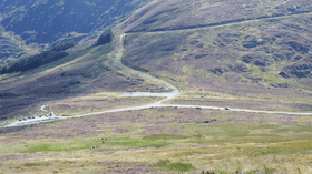
Wicklow Gap
| Wicklow Gap | |
|---|---|
| Bearna Chill Mhantáin | |
|
The pass from Tonelagee slopes | |
| Elevation | 475 m (1,558 ft)[1] |
| Traversed by | Road |
| Location | County Wicklow, Ireland |
| Range | Wicklow Mountains |
| Coordinates | 53°2′30.2″N 6°23′47.3″W / 53.041722°N 6.396472°WCoordinates: 53°2′30.2″N 6°23′47.3″W / 53.041722°N 6.396472°W |
 Location in Ireland | |
Wicklow Gap (Irish: Bearna Chill Mhantáin)[2] is one of the highest Irish mountain passes served by an asphalted road. It is located in County Wicklow, Ireland.
Geography
The 475-metre (1,558 ft) pass is opened between Tonelagee (Nort east) and Turlough Hill / Camaderry (South). It connects Dunlavin (West) and Glendalough, and with Sally Gap is one of the two road passes crossing the Wicklow Mountains. On clear days from the pass is possible to look across the Irish Sea and view the mountains of Snowdonia (Wales).[3]
Access to the pass

The scenic R756 road leads to the pass. The drive is a popular bicycle ascent;[4] it is considered by th the Tour de France a Cat. 3 climb.[5] From the pass starts a small road leading to Turlough Hill, where stands an electricity 'storage' hydro-plant.
Hiking
The pass is located on the St Kevins Way, a long distance waymarked walking trail, on its way from Hollywood to Glendalough.[6]
Starting from the pass is possible to reach on foot both Turlough Hill [7] and Tonelagee.[8]
See also
External links
- The Wicklow Gap on visitwicklow.ie
- ↑ John Christopher, Campbell McCutcheon (2015). Bradshaw's Guide: The Railways of Ireland. Amberley Publishing Limited. Retrieved 12 November 2016.
- ↑ "An Chonair (Conor Pass)". www.discoverireland.ie. Failte Ireland. Retrieved March 10, 2015.
- ↑ "The Wicklow Gap". Retrieved November 11, 2016.
- ↑ "Rathdrum - Wicklow Gap / Dublin cycle". cycleireland.ie. Retrieved November 11, 2016.
- ↑ "Stage 1 Brief". cyclingnews.com. Retrieved 2016-11-22.
- ↑
- ↑
- ↑
