Westover, Alabama
| Westover, Alabama | |
|---|---|
| City | |
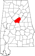
 Location of Westover in Shelby County, Alabama. | |
 Westover, Alabama Location of Westover in Shelby County, Alabama. | |
| Coordinates: 33°20′58″N 86°32′49″W / 33.34944°N 86.54694°W | |
| Country | United States |
| State | Alabama |
| County | Shelby |
| Government | |
| • Type | Mayor/Council |
| • Mayor | Mayor Larry H. Riggins |
| Area[1] | |
| • City | 18.27 sq mi (47.31 km2) |
| • Land | 18.14 sq mi (46.98 km2) |
| • Water | 0.13 sq mi (0.33 km2) |
| Elevation | 482 ft (147 m) |
| Population (2010) | |
| • City | 1,275 |
| • Estimate (2016)[2] | 1,542 |
| • Density | 85.01/sq mi (32.82/km2) |
| • Metro | 1,200,000 |
| Time zone | Central (CST) (UTC-6) |
| • Summer (DST) | CDT (UTC-5) |
| ZIP code | 35147; 35185; 35043; 35186; 35051; 35078 |
| Area code(s) | 205 |
| FIPS code | 01-81504 |
| GNIS feature ID | 157244 |
| Website | http://www.westoveralabama.org/ |
Westover is a city in Shelby County, Alabama, United States. It was officially incorporated on January 31, 2001 although it was established in 1901[3] and had a population of 961 when it was incorporated in 2001.[4]
History
One structure in Westover, the Archer House, is listed on the Alabama Register of Landmarks and Heritage.[5]
Geography
Westover is located at 33°22′42″N 86°32′13″W / 33.378305°N 86.536849°W.[6]
According to the U.S. Census Bureau, the city has a total area of 18.268 square miles (47.31 km2), of which 18.14 square miles (47.0 km2) is land and 0.128 square miles (0.33 km2) is water.
Westover is located along the busy U.S. Highway 280 corridor in the northeastern quadrant of Shelby County.[7] It is approximately twelve miles south of downtown Birmingham and is part of the Birmingham–Hoover Metropolitan Statistical Area. The Westover City Fire Department is rated a 3/3X by ISO.
Pine Mountain Preserve, the largest development of its kind ever built in the State of Alabama, is an Eddleman Properties development which has been announced. It is on 6,500 acres of property in the City of Westover including a "Town Center". The "Town Center" includes parks, City development sites (City Hall, Library, Fire Stations, etc.), multiple school sites and commercial.
Education
The Shelby County School system covers the City of Westover as well as several area private schools. On July 19, 2011 the City Council passed a Resolution identifying multiple properties, within the Chelsea Area School Zone, available for donation to the Shelby County Board of Education.
Demographics
| Historical population | |||
|---|---|---|---|
| Census | Pop. | %± | |
| 2010 | 1,275 | — | |
| Est. 2016 | 1,542 | [2] | 20.9% |
| U.S. Decennial Census[8] 2013 Estimate[9] | |||
The City of Westover has experienced significant growth over the last few years. The newest residential subdivisions in the City of Westover include Chelsea Square, Carden Crest, The Villages of Westover, Willow Oaks and Yellowleaf Farms. Over seventy-five percent on the property in the City is owned by residential and or commercial developers.
Government
Mayor J. Mark McLaughlin has been mayor since 2004 and chaired the Planning Commission from 2002-2004.
Notable person
- Jim Bragan, former college baseball and minor league baseball president
References
- ↑ "2016 U.S. Gazetteer Files". United States Census Bureau. Retrieved Jul 17, 2017.
- 1 2 "Population and Housing Unit Estimates". Retrieved June 9, 2017.
- ↑ "Boundary Changes". Geographic Change Notes: Alabama. Population Division, United States Census Bureau. 2006-05-19. Retrieved 2008-08-24.
- ↑ "Table 4. Annual Estimates of the Population for Incorporated Places in Alabama: April 1, 2000 to July 1, 2007" (CSV). United States Census Bureau, Population Division. 2007-07-10. Retrieved 2008-08-24.
- ↑ "Properties on the Alabama Register of Landmarks & Heritage". Alabama Historical Commission. www.preserveala.org. Retrieved June 5, 2014.
- ↑ "US Gazetteer 2016". United States Census Bureau. 2011-02-12. Retrieved 2017-06-08.
- ↑ Westover – Shelby County Tourism Bureau.
- ↑ "U.S. Decennial Census". Census.gov. Retrieved June 6, 2013.
- ↑ "Annual Estimates of the Resident Population: April 1, 2010 to July 1, 2013". Retrieved June 3, 2014.
Coordinates: 33°20′58″N 86°32′09″W / 33.34944°N 86.53583°W
