Western Kangaroo Island Commonwealth Marine Reserve
| Western Kangaroo Island Commonwealth Marine Reserve Australia | |
|---|---|
 Western Kangaroo Island Commonwealth Marine Reserve | |
| Nearest town or city | Kingscote, South Australia |
| Coordinates | 35°45′52.56″S 136°17′3.84″E / 35.7646000°S 136.2844000°ECoordinates: 35°45′52.56″S 136°17′3.84″E / 35.7646000°S 136.2844000°E |
| Established | 8 December 2012[1] |
| Area | 2,335.31 km2 (901.7 sq mi)[2] |
| Managing authorities | Department of the Environment and Energy |
| Website | Western Kangaroo Island Commonwealth Marine Reserve |
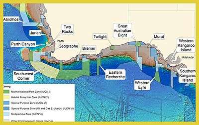
Western Kangaroo Island Commonwealth Marine Reserve is a marine protected area located south of South Australia in waters within the Australian Exclusive economic zone to the south-west of Kangaroo Island and ranging in depth from 15 metres (49 feet) to 165 metres (541 feet).[3][4]
It was gazetted in November 2012.[1]
It is part of a group of Commonwealth marine reserves managed by the Department of the Environment and Energy known as the South-west Commonwealth Marine Reserves Network. It is intimately associated with the Western Kangaroo Island Marine Park managed by the Government of South Australia which it both bounds on its north-west side and fully encloses the portion of the state marine park surrounding Lipson Reef near its eastern extent.[5][4]
The reserve includes ecosystems representative of the bioregion known as the "Spencer Gulf Shelf Province", two "key ecological features" consisting of firstly of a feature known as the "Kangaroo Island Pool" and the associated "Eyre Peninsula upwelling" both notable for their "high productivity, breeding and feeding aggregations" and secondly of a feature described as "Ancient coastline" within a depth range of 90–120 metres (300–390 ft) and as being of "high productivity", a calving area for southern right whale and feeding areas for the following species - Australian sea lion, blue whale, Caspian tern, great white shark, short-tailed shearwater and sperm whale.[3]
The reserve consists of two zones - a marine national park zone (IUCN Category II) with an area of 120 square kilometres (46 square miles) and a special purpose zone (IUCN Category VI) with an area of 2,215 square kilometres (855 square miles).[2][4]

See also
References
- 1 2 "Environment Protection and Biodiversity Conservation (Commonwealth Marine Reserves) Proclamation 2012 - F2012L02188". Commonwealth of Australia, Comlaw. Retrieved 19 March 2015.
- 1 2 "Collaborative Australian Protected Area Database (CAPAD) - consolidated data set for all marine protected areas in Australian State and Commonwealth waters (refer "DETAIL’ tab)". Department of the Environment. Retrieved 12 July 2015.
- 1 2 "Western Kangaroo Island Commonwealth Marine Reserve". Department of the Environment (DoE). Retrieved 12 July 2015.
- 1 2 3 "Western Kangaroo Island Commonwealth Marine Reserve - Maps". Department of the Environment (DoE). Retrieved 12 July 2015.
- ↑ "Western Kangaroo Island Marine Park Management Plan 2012" (PDF). Department of Environment Water and Natural Resources. 2012. p. 28. Retrieved 15 May 2014.