West Grove (Cardiff)
Coordinates: 51°26′55″N 3°10′08″W / 51.4485°N 3.169°W

West Grove looking north at the junction on Newport Road
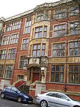
West Grove is a road in Roath, Cardiff, situated off Newport Road. The Queen's Buildings of Cardiff University,[1] Kings Monkton School and the former West Grove Unitarian Church are all located in West Grove. The Mansion House is officially in Richmond Road, but it is at the extreme end of West Grove and dominates the northern end.
History
West Grove was one of the villa-lined roads that formed the wealthy residential district of Tredegarville, laid out for the Tredegar Estate during the third quarter of the nineteenth century.[2]
Important buildings and structures in West Grove

Public Analyst's Laboratory in the Queen's Buildings
.jpg)
The Victorian listed post box
Kings Monkton School was established in 1870, and is an independent day school.[3]
Grade II listed structures
- The West Grove Unitarian Church is a Grade II Listed building.[4]
- Part of Cardiff University, The Queen's Buildings in The Parade (East facade is on West Grove) contains the Public Analyst's Laboratory in which is Grade II Listed.
- The megalithic folly at James Howell House.[5]
- The red pillar post box at the junction between West Grove and Richmond Crescent.[6]
See also
Notes
- ↑ Cardiff University city centre map
- ↑ Newman, John (1995), The Buildings of Wales: Glamorgan, Penguin Books, p. 309, ISBN 0-14-071056-6, retrieved 2014-11-24
- ↑ Kings Monkton School website
- ↑ "Unitarian Church, Plasnewydd". Cadw. Retrieved 24 January 2010.
- ↑ "Megalithic folly at James Howell House, Plasnewydd". Cadw. Retrieved 24 January 2010.
- ↑ "Pillar Box in West Grove". Cadw. Retrieved 24 January 2010.
This article is issued from
Wikipedia.
The text is licensed under Creative Commons - Attribution - Sharealike.
Additional terms may apply for the media files.