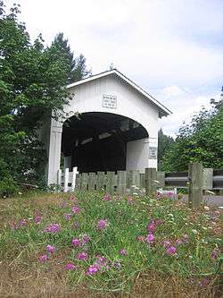
Wendling Bridge
|
Wendling Bridge | |
 | |
  | |
| Nearest city | Marcola, Oregon |
|---|---|
| Coordinates | 44°11′29″N 122°47′56″W / 44.1914°N 122.7989°WCoordinates: 44°11′29″N 122°47′56″W / 44.1914°N 122.7989°W |
| Area | 0.1 acres (0.040 ha) |
| Built | 1938 |
| Architectural style | Howe Truss |
| MPS | Oregon Covered Bridges TR |
| NRHP Reference # | 79002095[1] |
| Added to NRHP | November 29, 1979 |
The Wendling Bridge is a covered bridge in Lane County in the U.S. state of Oregon. The 60-foot (18 m) Howe truss structure carries Wendling Road over Mill Creek in the unincorporated community of Wendling.[2] Built in 1938, the bridge was added to the National Register of Historic Places in 1979.[3]
Lane County built four covered bridges, including the Wendling Bridge, in 1936. The others are the Pengra, Goodpasture Bridge, and Earnest bridges.[4] A. C. Striker was then the county bridge superintendent.[5]
Notable features of the bridge include semi-elliptical portal arches and ribbon openings at the eaves.[5] The structure was named for George X. Wendling, who established a post office nearby in the 1890s.[5]
See also
- List of bridges on the National Register of Historic Places in Oregon
- National Register of Historic Places listings in Lane County, Oregon
References
- ↑ "Wendling Bridge". National Park Service. Retrieved March 16, 2016.
- ↑ "Mill Creek (Wendling) Covered Bridge" (PDF). Oregon Department of Transportation. Retrieved March 16, 2016.
- ↑ "Oregon National Register List" (PDF). Oregon Parks and Recreation Department. June 6, 2011. p. 23. Retrieved July 17, 2011.
- ↑ "Wendling Creek Covered Bridge". Lane County, Oregon. Retrieved March 16, 2016.
- 1 2 3 Smith, Dwight A.; Norman, James B.; Dykman, Pieter T. (1989) [1986]. Historic Highway Bridges of Oregon (2nd ed.). Portland: Oregon Historical Society Press. p. 169. ISBN 0-87595-205-4.
External links
-
 Media related to Wendling Bridge at Wikimedia Commons
This article is issued from
Wikipedia.
The text is licensed under Creative Commons - Attribution - Sharealike.
Additional terms may apply for the media files.

