Waw an Namus
| Waw an Namus | |
|---|---|
 | |
| Highest point | |
| Elevation | 547 m (1,795 ft) |
| Coordinates | 24°55′0″N 17°46′0″E / 24.91667°N 17.76667°ECoordinates: 24°55′0″N 17°46′0″E / 24.91667°N 17.76667°E |
| Geography | |
 Waw an Namus Location in Libya | |
| Location | Libya |
| Geology | |
| Mountain type | Caldera and volcanic field |
| Last eruption | Unknown |
Waw an Namus (also spelled Wau-en-Namus, Arabic: واو الناموس, Oasis of Mosquitoes[1]) is a volcanic field, cone and caldera in the southern Fezzan region of southern Libya. It is in the near-geographic center of the Sahara Desert.
Description
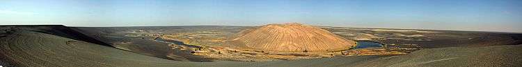
The inside of the caldera houses an oasis of rich foliage and three small salt lakes of variable color which are the reason for the volcano's name. A volcanic field of dark basaltic tephra flow extends 10–20 kilometres (6.2–12.4 mi) around the caldera.[1] The dark field's vast size allows it to be easily seen from space.
Access
Prior to the Libyan Civil War (2011), Waw an Namus was an increasingly popular local tourist attraction.
Image gallery
 Waw an Namus viewed from the Space Shuttle, 25 October 1992
 Green salt lake
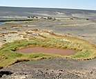 Red lake
See also
References
- 1 2 "Global Volcanism Program - Wau-en-Namus". si.edu.
External links
![]() Media related to Waw an Namus at Wikimedia Commons
Media related to Waw an Namus at Wikimedia Commons
This article is issued from
Wikipedia.
The text is licensed under Creative Commons - Attribution - Sharealike.
Additional terms may apply for the media files.