Hardee County, Florida
| Hardee County, Florida | ||
|---|---|---|
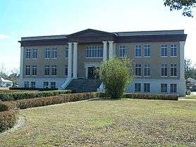
 Hardee County Courthouse | ||
| ||
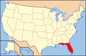
 Location in the U.S. state of Florida | ||
 Florida's location in the U.S. | ||
| Founded | April 23, 1921 | |
| Named for | Cary A. Hardee | |
| Seat | Wauchula | |
| Largest city | Wauchula | |
| Area | ||
| • Total | 638 sq mi (1,652 km2) | |
| • Land | 638 sq mi (1,652 km2) | |
| • Water | 0.6 sq mi (2 km2), 0.1% | |
| Population (est.) | ||
| • (2015) | 27,502 | |
| • Density | 43/sq mi (17/km²) | |
| Congressional district | 17th | |
| Time zone | Eastern: UTC-5/-4 | |
| Website |
www | |
Hardee County is a county located in the U.S. state of Florida. As of the 2010 census, the population was 27,731.[1] Its county seat is Wauchula.[2]
Hardee County comprises the Wauchula, FL Micropolitan Statistical Area.
History
It was named for Cary A. Hardee, Governor of Florida from 1921 to 1925. Hardee County was created in 1921.
On August 13, 2004, Hurricane Charley went directly through Hardee County. Maximum sustained winds in downtown Wauchula were clocked at 149 mph (240 km/h) with higher gusts. Most buildings in the county sustained damage, and many were totally destroyed.
Geography
According to the U.S. Census Bureau, the county has a total area of 638 square miles (1,650 km2), of which 638 square miles (1,650 km2) is land and 0.6 square miles (1.6 km2) (%) is water.[3]
Adjacent counties
- Polk County, Florida - north
- Highlands County, Florida - east
- DeSoto County, Florida - south
- Manatee County, Florida - west
- Hillsborough County, Florida - northwest
Demographics
| Historical population | |||
|---|---|---|---|
| Census | Pop. | %± | |
| 1930 | 10,348 | — | |
| 1940 | 10,158 | −1.8% | |
| 1950 | 10,073 | −0.8% | |
| 1960 | 12,370 | 22.8% | |
| 1970 | 14,889 | 20.4% | |
| 1980 | 19,379 | 30.2% | |
| 1990 | 19,499 | 0.6% | |
| 2000 | 26,938 | 38.2% | |
| 2010 | 27,731 | 2.9% | |
| Est. 2016 | 27,360 | [4] | −1.3% |
| U.S. Decennial Census[5] 1790-1960[6] 1900-1990[7] 1990-2000[8] 2010-2015[1] | |||
As of the census[9] of 2000, there were 26,938 people, 8,166 households, and 6,255 families residing in the county. The population density was 42 people per square mile (16/km²). There were 9,820 housing units at an average density of 15 per square mile (6/km²). The racial makeup of the county was 70.66% White, 8.33% Black or African American, 0.68% Native American, 0.30% Asian, 0.06% Pacific Islander, 17.99% from other races, and 1.97% from two or more races. 35.68% of the population were Hispanic or Latino of any race.
According to 2005 Census Estimates the county's population was 50.6% non-Hispanic white, 39.8% Latino, 9.0% African-American and 1.3% Native American. (source=http://quickfacts.census.gov/qfd/states/12/12049.html)
In 2000 there were 8,166 households out of which 34.90% had children under the age of 18 living with them, 60.00% were married couples living together, 11.10% had a female householder with no husband present, and 23.40% were non-families. 18.00% of all households were made up of individuals and 9.40% had someone living alone who was 65 years of age or older. The average household size was 3.06 and the average family size was 3.40.
In the county, the population was spread out with 27.60% under the age of 18, 11.00% from 18 to 24, 28.30% from 25 to 44, 19.20% from 45 to 64, and 13.90% who were 65 years of age or older. The median age was 33 years. For every 100 females there were 119.10 males. For every 100 females age 18 and over, there were 123.00 males.
The median income for a household in the county was $30,183, and the median income for a family was $32,487. Males had a median income of $23,793 versus $18,823 for females. The per capita income for the county was $12,445. About 17.00% of families and 24.60% of the population were below the poverty line, including 30.20% of those under age 18 and 16.10% of those age 65 or over.
Politics
| Year | Republican | Democratic | Other |
|---|---|---|---|
| 2016 | 68.57% 5,242 | 28.11% 2,149 | 3.32% 254 |
| 2012 | 64.83% 4,696 | 34.00% 2,463 | 1.17% 85 |
| 2008 | 64.00% 4,763 | 34.51% 2,568 | 1.49% 111 |
| 2004 | 69.65% 5,049 | 29.65% 2,149 | 0.70% 51 |
| 2000 | 60.38% 3,765 | 37.56% 2,342 | 2.07% 129 |
| 1996 | 47.18% 2,928 | 38.95% 2,417 | 13.87% 861 |
| 1992 | 45.08% 2,900 | 31.37% 2,018 | 23.55% 1,515 |
| 1988 | 66.96% 3,640 | 31.05% 1,688 | 1.99% 108 |
| 1984 | 72.06% 3,962 | 27.94% 1,536 | |
| 1980 | 48.82% 2,603 | 48.74% 2,599 | 2.44% 130 |
| 1976 | 42.86% 2,189 | 52.28% 2,670 | 4.86% 248 |
| 1972 | 84.57% 3,563 | 15.36% 647 | 0.07% 3 |
| 1968 | 28.34% 1,278 | 15.59% 703 | 56.08% 2,529 |
| 1964 | 54.88% 2,321 | 45.12% 1,908 | |
| 1960 | 52.96% 1,960 | 47.04% 1,741 | |
| 1956 | 45.67% 1,589 | 54.33% 1,890 | |
| 1952 | 46.55% 1,802 | 53.45% 2,069 | |
| 1948 | 24.12% 689 | 65.49% 1,871 | 10.40% 297 |
| 1944 | 24.72% 708 | 75.28% 2,156 | |
| 1940 | 21.33% 694 | 78.67% 2,559 | |
| 1936 | 28.27% 844 | 71.73% 2,142 | |
| 1932 | 18.55% 566 | 81.45% 2,485 | |
| 1928 | 70.06% 2,087 | 27.73% 826 | 2.22% 66 |
| 1924 | 22.66% 264 | 68.24% 795 | 9.10% 106 |
Libraries
Hardee County is part of the Heartland Library Cooperative which has 7 branches that serve Hardee County and some of the surrounding counties in the Florida Heartland, including Glades, Highlands, DeSoto, and Okeechobee.
- Avon Park
- DeSoto
- Glades
- Hardee
- Lake Placid
- Okeechobee
- Sebring
The mission of the Hardee County Public Library is to provide quality materials and services to fulfill educational, informational, cultural, and recreational needs of the county residents. The library works to maintain a spacious, modern, and inviting environment to accommodate multiple activities and services to the patrons. County patrons are about to search through the provided Historical Resources to find county historical information. Obituaries requests are available for all five countries in the Heartland region with no charge. American genealogical sources are accessible through the HeritageQuest Online database where family history can be found. Museums and Historical Societies are on the library's website such as Depot Museum, the Cracker Trail Museum Pioneer Park, DeSoto County, Florida Historical Society, and the Sebring Historical Society. Also, the library provide E-Books, Audiobooks, and other online resources on their website. These resources are available for us on Apple, Kindle, Android, and Windows devices. Additionally, Ask a Librarian, the on-line Florida librarian reference service is available through the Heartland Library Cooperative Library. Here the patrons can chat, text, and email with a librarian. The library offers language and learning programs like basic ESL to improve listening, speaking, reading, and writing skills. Other online continuing education classes are easy to access through the library's website. Another program that the library offers is the Little Free Library where patrons can take and leave a book at designated location throughout the county that are free to use. <http://myhlc.org>
Hours of Operation: Monday 10:00am-6:30pm Tuesday 9:00am-5:30pm Wednesday 9:00am-5:00pm Thursday 9:00am-5:00pm Friday 9:00am-4:00pm Saturday Closed Sunday Closed
Communities
Cities
Town
Census-designated places
Other unincorporated communities
- Crewsville
- Lake Dale
- Oak Grove
- Popash
- Sweetwater Ranch
- Village of Charlie Creek
Transportation
Airports
See also
References
- 1 2 "State & County QuickFacts". United States Census Bureau. Retrieved February 14, 2014.
- ↑ "Find a County". National Association of Counties. Retrieved 2011-06-07.
- ↑ "US Gazetteer files: 2010, 2000, and 1990". United States Census Bureau. 2011-02-12. Retrieved 2011-04-23.
- ↑ "Population and Housing Unit Estimates". Retrieved June 9, 2017.
- ↑ "U.S. Decennial Census". United States Census Bureau. Retrieved June 14, 2014.
- ↑ "Historical Census Browser". University of Virginia Library. Retrieved June 14, 2014.
- ↑ "Population of Counties by Decennial Census: 1900 to 1990". United States Census Bureau. Retrieved June 14, 2014.
- ↑ "Census 2000 PHC-T-4. Ranking Tables for Counties: 1990 and 2000" (PDF). United States Census Bureau. Retrieved June 14, 2014.
- ↑ "American FactFinder". United States Census Bureau. Retrieved 2011-05-14.
- ↑ http://uselectionatlas.org/RESULTS
External links
| Wikimedia Commons has media related to Hardee County, Florida. |
Government links/Constitutional offices
- Hardee County Board of County Commissioners official website
- Hardee County Supervisor of Elections
- Hardee County Property Appraiser
- Hardee County Sheriff's Office
- Hardee County Tax Collector
Special districts
- Hardee County Public Schools
- Southwest Florida Water Management District
- Heartland Library Cooperative
Judicial branch
- Hardee County Clerk of Courts (Official Site)
- Public Defender, 10th Judicial Circuit of Florida serving Hardee, Highlands, and Polk counties
- Office of the State Attorney, 10th Judicial Circuit of Florida
- Circuit and County Court for the 10th Judicial Circuit of Florida
Museum and Library Resources
- Heartland Library Cooperative. Hardee County is part of the Heartland Library Cooperative
- The Herald-Advocate, the local newspaper for Hardee County, Florida fully and openly available in the Florida Digital Newspaper Library
Other Resources
Coordinates: 27°29′N 81°49′W / 27.49°N 81.81°W


