Walther (crater)
|
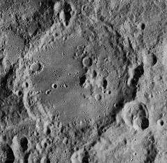
Lunar Orbiter 4 image | |
| Coordinates | 33°00′S 0°42′E / 33.0°S 0.7°ECoordinates: 33°00′S 0°42′E / 33.0°S 0.7°E |
|---|---|
| Diameter | 132 × 140 km |
| Depth | 4.1 km |
| Colongitude | 359° at sunrise |
| Eponym | Bernhard Walther |
- Not to be confused with Walter, a tiny crater near Diophantus.
Walther is an ancient lunar impact crater located in the southern highland region of the Moon. It is joined along the western rim to the crater Deslandres. To the northeast is Aliacensis, and joined to the southeast rim is the irregular Nonius.
Description
The rim of Walther is complex, heavily eroded and incised by lesser impacts. The wall retains a generally circular form, but many of its features have been worn away and there is a slight protruding bulge in the western rim. The floor has been resurfaced after the original impact, leaving the southwestern half relatively smooth. In the northwest quadrant is an offset central peak that has been worn and impacted by several small craters.
Names
Walther is named after the German astronomer Bernhard Walther. Like many of the craters on the Moon's near side, it was named (in the Latin form, 'Valtherus') by Giovanni Riccioli, whose 1651 nomenclature system has become standardized.[1] Earlier lunar cartographers had given the feature different names: Michael van Langren's 1645 map calls it "Caroli I Reg. Britt.", after King Charles I of England,[2] and Johannes Hevelius grouped it with Purbach and Regiomontanus as "Mons Libanus" after Mount Lebanon.[3]
Satellite craters
By convention these features are identified on lunar maps by placing the letter on the side of the crater midpoint that is closest to Walther.
| Walther | Latitude | Longitude | Diameter |
|---|---|---|---|
| A | 32.4° S | 0.7° E | 12 km |
| B | 30.5° S | 1.4° W | 9 km |
| C | 31.2° S | 0.8° W | 14 km |
| D | 32.0° S | 2.8° E | 18 km |
| E | 33.3° S | 1.2° W | 13 km |
| F | 33.1° S | 2.1° E | 6 km |
| G | 32.5° S | 3.9° W | 8 km |
| J | 34.4° S | 1.5° W | 7 km |
| K | 34.1° S | 1.4° W | 7 km |
| L | 31.9° S | 0.9° W | 5 km |
| M | 34.0° S | 0.3° W | 5 km |
| N | 33.7° S | 0.2° W | 6 km |
| O | 35.6° S | 0.1° W | 6 km |
| P | 35.4° S | 0.2° E | 9 km |
| Q | 33.5° S | 0.3° E | 4 km |
| R | 35.8° S | 0.4° E | 8 km |
| S | 36.4° S | 0.6° E | 12 km |
| T | 33.4° S | 1.8° E | 8 km |
| U | 33.4° S | 2.7° E | 4 km |
| W | 32.8° S | 2.5° W | 36 km |
| X | 32.1° S | 1.9° W | 10 km |
References
- Andersson, L. E.; Whitaker, E. A. (1982). NASA Catalogue of Lunar Nomenclature. NASA RP-1097.
- Blue, Jennifer (July 25, 2007). "Gazetteer of Planetary Nomenclature". USGS. Retrieved 2007-08-05.
- Bussey, B.; Spudis, P. (2004). The Clementine Atlas of the Moon. New York: Cambridge University Press. ISBN 978-0-521-81528-4.
- Cocks, Elijah E.; Cocks, Josiah C. (1995). Who's Who on the Moon: A Biographical Dictionary of Lunar Nomenclature. Tudor Publishers. ISBN 978-0-936389-27-1.
- McDowell, Jonathan (July 15, 2007). "Lunar Nomenclature". Jonathan's Space Report. Retrieved 2007-10-24.
- Menzel, D. H.; Minnaert, M.; Levin, B.; Dollfus, A.; Bell, B. (1971). "Report on Lunar Nomenclature by the Working Group of Commission 17 of the IAU". Space Science Reviews. 12 (2): 136–186. Bibcode:1971SSRv...12..136M. doi:10.1007/BF00171763.
- Moore, Patrick (2001). On the Moon. Sterling Publishing Co. ISBN 978-0-304-35469-6.
- Price, Fred W. (1988). The Moon Observer's Handbook. Cambridge University Press. ISBN 978-0-521-33500-3.
- Rükl, Antonín (1990). Atlas of the Moon. Kalmbach Books. ISBN 978-0-913135-17-4.
- Webb, Rev. T. W. (1962). Celestial Objects for Common Telescopes (6th revised ed.). Dover. ISBN 978-0-486-20917-3.
- Whitaker, Ewen A. (1999). Mapping and Naming the Moon. Cambridge University Press. ISBN 978-0-521-62248-6.
- Wlasuk, Peter T. (2000). Observing the Moon. Springer. ISBN 978-1-85233-193-1.
