Voždovac
| Voždovac Вождовац | ||
|---|---|---|
| Urban neighborhood and municipality | ||
|
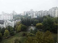
Braće Jerković neighbourhood | ||
| ||
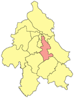 Location of Voždovac within the city of Belgrade | ||
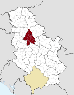 Location of the city of Belgrade within Serbia | ||
| Country |
| |
| City | Belgrade | |
| Status | Municipality | |
| Settlements | 5 | |
| Government | ||
| • Type | Municipality of Belgrade | |
| • Mun. president | Aleksandar Savić (SNS) | |
| Area | ||
| • Total | 148 km2 (57 sq mi) | |
| Population (2011) | ||
| • Total | 158,213 | |
| • Density | 1,100/km2 (2,800/sq mi) | |
| Time zone | CET (UTC+1) | |
| • Summer (DST) | CEST (UTC+2) | |
| Postal code | 11040 | |
| Area code(s) | +381(0)11 | |
| Car plates | BG | |
| Website |
www | |

Voždovac (Serbian Cyrillic: Вождовац, pronounced [ʋǒːʒdoʋats]) is an urban neighborhood and one of 17 city municipalities which constitute the city of Belgrade, the capital of Serbia. According to the 2011 census results, the municipality has a population of 158,213 inhabitants.
Neighborhood
Location
The neighborhood of Voždovac is located 4 to 5 kilometres (2 to 3 miles) south of downtown Belgrade, on a hill in the northern part of the municipality. Three long, more or less parallel streets shape the neighborhood into an elongated form in the north-west to south-east direction: western border is marked by Bulevar Oslobođenja (Boulevard of Liberation), which also makes the border to the municipality of Savski Venac, eastern by Kumodraška Street, while Vojvode Stepe Street stretches in between. Due to its shape, Voždovac borders many other neighborhoods: Autokomanda to the north, Diplomatska Kolonija on the north-west, Banjica (and Banjica Forest) on the west, Trošarina and Banjica II on the south-west, Kumodraž (its sub-neighborhoods of Kumodraž II and Torlak) on the south, Braće Jerković II and Mitrovo Brdo on the south-east, Braće Jerković on the east and Dušanovac on the north-east.
Name and history
Name Voždovac is derived from the word vožd meaning leader (literally, a "duke", "supreme vojvoda"), one of the titles used by the Karađorđe Petrović, the leader of the First Serbian Uprising. He also commanded the liberation of Belgrade from the Turks in 1806, and on the very spot from where he started that operation today stands a Church of the Saint Emperor Constantine and Helena, popularly called the Voždovac Church (Voždovačka crkva). The spot he has chosen was outside of the "Laudan's trench", too distant for the Turks inside the trench to notice the Serbian fighters gathering but close enough to take the chargeon the trench. Settlement that subsequently developed was known as "Činovnička kolonija" (Clerk's colony). Still operational elementary school "Branislav Nušić" was built in 1935 and the neighborhood was officially named "Predgrađe Kraljice Marije" or Queen Maria's Suburb, after the dowager queen Maria of Yugoslavia. Later, inhabitants colloquially began to use name Voždovac which spread and was adopted as the official name.[1]
Characteristics
Originally a residential area, as the neighborhood was growing and stretching to the south, it developed different features. The south-western extension to Torlak, along the Vojvode Stepe street, developed almost rural look, while the southern extension into the Kumodraž II is turned into one of the most heavily industrialized areas in the "Old Belgrade". The western area, along the Boulevard of Liberation became somewhat of an elite neighborhood. Three faculties of the University of Belgrade are located in the neighborhood: Management (FON), Political sciences (FPN) and Transportation. Population of the neighborhood was 22,516 in 2002[2] and 23,153 in 2011.[3]
Municipality
Location
The municipality is located in the south-central part of the urban area of Belgrade and in the central section of the wider Belgrade City area. It stretches meridonally (north to south) for almost 40 kilometers (25 mi), spreading to the south more than any other urban municipality of Belgrade. Due to its shape, it borders more municipalities than any other: Vračar on the north, Zvezdara on the north-east, Grocka on the east, Sopot on the south, Barajevo on the south-west, Čukarica and Rakovica on the west and Savski Venac on the north-west.
Geography
Municipality is located in the northern section of the Šumadija region ("Low Šumadija"). The southern part covers the northern section of the woods of Lipovička šuma and roughly corresponds to the valley of the Topčiderka river which flows between the Pinosava and Ripanj plateaux. The central area is occupied by one of two "Belgrade" mountains, the 511 meters (1,677 ft) -high Avala (the other one being Kosmaj). In the northern, urban section, Voždovac covers several of the 32 hills on which Belgrade is built, including Torlak and Pašino Brdo.
Apart from Topčiderka, numerous smaller rivers and intermittent creeks flow in the northern part of the municipality: Zavojnička reka, Vranovac, Milošev potok, Bubanj Potok, Kamena voda, Lipica, Drenjak, Kumodraški potok and parts of Rakovički potok, Bolečica and Jelezovac. The spring and the valley of the former Mokroluški Potok (now mostly conducted underground) is also located in the municipality. Despite having large wooded areas in the non-urban section (slopes of Avala, northern part of Lipovička šuma, Stepin Lug/Gaj), the urban area has only one real park, Šumice.
Population
| Historical population | ||
|---|---|---|
| Year | Pop. | ±% |
| 1948 | 52,338 | — |
| 1953 | 61,200 | +16.9% |
| 1961 | 85,458 | +39.6% |
| 1971 | 134,206 | +57.0% |
| 1981 | 159,364 | +18.7% |
| 1991 | 161,376 | +1.3% |
| 2002 | 151,768 | −6.0% |
| 2011 | 158,213 | +4.2% |
| Source: [4] | ||
The massive population growth was halted in the late 1980s, despite still growing settlements on the southern and south-eastern outskirts of Belgrade. Still, with 1,061.8/km2 (2,750/sq mi), Voždovac is still densely populated, especially concerning large unurbanized areas in the south. Population of Voždovac according to the official census of population (since 1991 a new methodology is used):
Ethnic groups (2002 census)
- Serbs - 138,528 (91.28%)
- Montenegrins - 1,879 (1.24%)
- Croats - 1,810 (1.23%)
- Yugoslavs - 1,740 (1.15%)
- Macedonians - 902 (0.59%)
- Romani - 820 (0.54%)
Settlements
The municipality of Voždovac has both urban neighborhoods of the Belgrade City proper (uža teritorija grada) and separate, suburban settlements in the Belgrade City Metro area.
Urban:
|
Suburban towns:
Suburban rural:
History and administration
The municipality of Voždovac originates from 1904. In 1945 Belgrade was divided into districts (rejon) and Voždovac became part of District VI. In 1952 the districts were abolished and the municipalities re-established. Municipality of Pašino Brdo was annexed to Voždovac on September 1, 1955 and today makes its northernmost part. The municipality was territorially shaped in the early 1960s when the municipality of Ripanj was added to Voždovac (the village of Veliki Mokri Lug was later detached and annexed to the municipality of Zvezdara). However, shaped this way, the elongated municipality causes problem to the inhabitants of its southern part as they have to travel over 30 kilometers (19 mi) to the municipal assembly. There is an idea of separating suburban settlements (Beli Potok, Pinosava, Zuce, Ripanj) and creating new sub-Avalan municipality (Avalski Venac), with the village of Vrčin in the municipality of Grocka but no official move has been done so far in that direction.
Presidents of the municipal assembly:
- 1952–1955: Nikola Stepanović (b.1916)
- 1955–1956: Vučko Ivković (b.1913)
- 1956–1965: Petar Kolundžija
- 1965–1973: Zoran Nastić
- 1973–1978: Munir Lasić (d.2013)
- 1978–1982: Dragomir Marić
- 1982–1986: Borislav Kuzmanović
- 1986–1988: Milorad Leković
- 1988–1991: Zoran Višnjić
- 1991–1992: Zoran Antonić (b.1934,d.2009)
- 1992–1994: Božidar Simatković
- 1994–1997: Zoran Modrinić (b.1947)
- 1997–October 12, 2000: Nebojša Atanacković (b.1943)
- October 12, 2000–December 9, 2004: Stevan Radović (b.1940)
- December 9, 2004–January 27, 2010: Goran Lukačević (b.1966)
- January 27, 2010–January 31, 2014: Dragan Vukanić (b.1956)
- January 31, 2014–present: Aleksandar Savić (b.1971)
Economy
Suburban parts of the municipality are mostly agricultural, but the urban section has a large industrial zone, one of the largest in the city, mostly along the Kumodraška street. It comprises the factories of Vatrosprem, Tunelogradnja, Soko Štark, Napred, Montaža, Ratko Mitrović, etc. Some facilities of the Belgrade's Communal Company and of Electricity company (EDB) are located in the neighborhood of Marinkova Bara, along the highway. A small center of the building companies and cement plants is growing along Bubanj Potok.
Administrative center of the municipality is located in Dušanovac, along the Ustanička street. It encompasses the building of the Municipal assembly, the police and fire station, the local clinical-ambulance center, the Fifth Municipal Court of Belgrade and the Special section of the Supreme court of Serbia for organized crime and war crimes (formerly the Supreme Military Court of Yugoslavia).
The Belgrade-Niš highway passes through the northern and eastern parts of the municipality while the road of Kružni put (and the projected Belgrade beltway) goes through the central parts, including the junction of two roads and tollbooth on Bubanj Potok, which marks the entrance into the Belgrade City proper. A railway also goes through the municipality, parallel to the Kružni put.
International cooperation
Voždovac is twinned with following cities and municipalities:[5]
And has signed friendship charters with following cities and municipalities:
Sport
FK Voždovac are the neighbourhood team with significant local support. They play at the Voždovac Stadium.
See also
| Wikimedia Commons has media related to Voždovac. |
References
- ↑ Dragan Perić (23 April 2017), "Šetnja pijacama i parkovima", Politika-Magazin No 1021 (in Serbian), pp. 28–29
- ↑ Popis stanovništva po mesnim zajednicama, Saopštenje 40/2002, page 4. Zavod za informatiku i statistiku grada Beograda. 26 July 2002.
- ↑ Stanovništvo po opštinama i mesnim zajednicama, Popis 2011. Grad Beograd – Sektor statistike (xls file). 23 April 2015.
- ↑ "2011 Census of Population, Households and Dwellings in the Republic of Serbia" (PDF). stat.gov.rs. Statistical Office of the Republic of Serbia. Retrieved 26 February 2017.
- ↑ Stalna konferencija gradova i opština. Retrieved on 2007-06-18.
Sources
- Mala Prosvetina Enciklopedija, Third edition (1986); Prosveta; ISBN 86-07-00001-2
- Jovan Đ. Marković (1990): Enciklopedijski geografski leksikon Jugoslavije; Svjetlost-Sarajevo; ISBN 86-01-02651-6
External links
| Municipalities | ||
|---|---|---|


Coordinates: 44°47′N 20°29′E / 44.783°N 20.483°E