Mulmur, Ontario
| Mulmur | |
|---|---|
| Township (lower-tier) | |
| Township of Mulmur | |
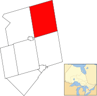
 Mulmur within Dufferin County | |
 Mulmur Location of Mulmur within Ontario | |
| Coordinates: 44°11.5′N 80°06.5′W / 44.1917°N 80.1083°WCoordinates: 44°11.5′N 80°06.5′W / 44.1917°N 80.1083°W | |
| Country |
|
| Province |
|
| County | Dufferin |
| Incorporated | January 1, 1851 |
| Government | |
| • Mayor | Paul Mills |
| • Federal riding | Dufferin—Caledon |
| • Prov. riding | Dufferin—Caledon |
| Area[1] | |
| • Land | 286.73 km2 (110.71 sq mi) |
| Population (2011)[1] | |
| • Total | 3,391 |
| • Density | 11.8/km2 (31/sq mi) |
| Time zone | EST (UTC-5) |
| • Summer (DST) | EDT (UTC-4) |
| Postal Code | L0N 1M0 |
| Area code(s) | 519 and 226 |
| Website | www.mulmurtownship.ca |
Mulmur is a township in Dufferin County in Southern Ontario, Canada. There are a number of original settlements such as Mulmur Corners, some of which can still be identified as to location, including Rosemont and Stanton.[2]
Demographics
| Canada census – Mulmur, Ontario community profile | |||
|---|---|---|---|
| 2011 | 2006 | ||
| Population: | 3,391 (2.2% from 2006) | 3,318 (7.1% from 2001) | |
| Land area: | 286.73 km2 (110.71 sq mi) | 286.73 km2 (110.71 sq mi) | |
| Population density: | 11.8/km2 (31/sq mi) | 11.6/km2 (30/sq mi) | |
| Median age: | 45.2 (M: 45.6, F: 44.7) | 42.3 (M: 42.2, F: 42.4) | |
| Total private dwellings: | 1643 | 1,479 | |
| Median household income: | $N/A | ||
| References: 2011[1] 2006[3] earlier[4] | |||
Population trend:[5]
- Population in 2006: 3318
- Population in 2001: 3099
- Population in 1996: 2903
- Population in 1991: 2591
Climate
| Climate data for Ruskview (Mulmur) 1981–2010 | |||||||||||||
|---|---|---|---|---|---|---|---|---|---|---|---|---|---|
| Month | Jan | Feb | Mar | Apr | May | Jun | Jul | Aug | Sep | Oct | Nov | Dec | Year |
| Record high °C (°F) | 13.5 (56.3) |
12.0 (53.6) |
22.5 (72.5) |
28.5 (83.3) |
31.5 (88.7) |
33.0 (91.4) |
34.0 (93.2) |
35.0 (95) |
33.0 (91.4) |
28.0 (82.4) |
20.0 (68) |
16.0 (60.8) |
35.0 (95) |
| Average high °C (°F) | −3.6 (25.5) |
−2.9 (26.8) |
2.3 (36.1) |
10.1 (50.2) |
17.1 (62.8) |
22.3 (72.1) |
24.7 (76.5) |
23.7 (74.7) |
19.5 (67.1) |
11.9 (53.4) |
4.9 (40.8) |
−1.3 (29.7) |
10.7 (51.3) |
| Daily mean °C (°F) | −7.3 (18.9) |
−6.8 (19.8) |
−1.9 (28.6) |
5.4 (41.7) |
12.1 (53.8) |
17.4 (63.3) |
19.7 (67.5) |
18.8 (65.8) |
14.7 (58.5) |
7.9 (46.2) |
1.7 (35.1) |
−4.3 (24.3) |
6.4 (43.5) |
| Average low °C (°F) | −10.9 (12.4) |
−10.7 (12.7) |
−6.0 (21.2) |
0.8 (33.4) |
7.0 (44.6) |
12.4 (54.3) |
14.7 (58.5) |
13.9 (57) |
9.9 (49.8) |
3.8 (38.8) |
−1.6 (29.1) |
−7.3 (18.9) |
2.2 (36) |
| Record low °C (°F) | −31.5 (−24.7) |
−30.0 (−22) |
−29.0 (−20.2) |
−13.0 (8.6) |
−3.5 (25.7) |
2.0 (35.6) |
5.0 (41) |
4.0 (39.2) |
−3.0 (26.6) |
−7.0 (19.4) |
−18.5 (−1.3) |
−29.5 (−21.1) |
−31.5 (−24.7) |
| Average precipitation mm (inches) | 85.6 (3.37) |
69.8 (2.748) |
68.0 (2.677) |
73.9 (2.909) |
86.9 (3.421) |
90.8 (3.575) |
81.5 (3.209) |
79.4 (3.126) |
95.4 (3.756) |
83.3 (3.28) |
100.3 (3.949) |
80.9 (3.185) |
995.8 (39.205) |
| Average rainfall mm (inches) | 21.1 (0.831) |
15.7 (0.618) |
31.2 (1.228) |
60.7 (2.39) |
86.7 (3.413) |
90.8 (3.575) |
81.5 (3.209) |
79.4 (3.126) |
95.4 (3.756) |
73.8 (2.906) |
60.8 (2.394) |
21.0 (0.827) |
718.0 (28.268) |
| Average snowfall cm (inches) | 64.6 (25.43) |
54.1 (21.3) |
36.6 (14.41) |
13.2 (5.2) |
0.2 (0.08) |
0.0 (0) |
0.0 (0) |
0.0 (0) |
0.0 (0) |
9.4 (3.7) |
39.5 (15.55) |
59.9 (23.58) |
277.5 (109.25) |
| Average precipitation days (≥ 0.2 mm) | 15.7 | 12.7 | 12.6 | 13.0 | 13.2 | 12.2 | 11.4 | 12.1 | 13.4 | 17.3 | 18.1 | 15.0 | 166.8 |
| Average rainy days (≥ 0.2 mm) | 3.2 | 3.0 | 6.0 | 11.5 | 13.2 | 12.2 | 11.4 | 12.1 | 13.5 | 16.5 | 12.5 | 4.1 | 119.1 |
| Average snowy days (≥ 0.2 cm) | 13.5 | 10.3 | 7.6 | 2.7 | 0.1 | 0.0 | 0.0 | 0.0 | 0.0 | 1.8 | 6.9 | 11.6 | 54.4 |
| Source: Environment Canada[6] | |||||||||||||
See also
References
- 1 2 3 "Mulmur, Ontario (Code 3522016) census profile". 2011 Census of Population. Statistics Canada. Retrieved 2012-08-14.
- ↑ "Our Roots / Nos Racines".
- ↑ "2006 Community Profiles". Canada 2006 Census. Statistics Canada. March 30, 2011. Retrieved 2009-02-24.
- ↑ "2001 Community Profiles". Canada 2001 Census. Statistics Canada. February 17, 2012.
- ↑ Statistics Canada: 1996, 2001, 2006 census
- ↑ "Ruskview". Canadian Climate Normals 1981−2010. Environment Canada. Retrieved 2016-05-12.
External links
This article is issued from
Wikipedia.
The text is licensed under Creative Commons - Attribution - Sharealike.
Additional terms may apply for the media files.
