Banbury Road
| Route information | |
|---|---|
| Length: | 3.7 mi (6.0 km) |
| Major junctions | |
| South end: | Oxford |
|
| |
| North end: | Near Kidlington |
| Road network | |
Banbury Road[1] is a major arterial road in Oxford, England, running from St Giles' at the south end, north towards Banbury through the leafy suburb of North Oxford and Summertown, with its local shopping centre. Parallel and to the west is the Woodstock Road, which it meets at the junction with St Giles'. To the north, Banbury Road meets the Oxford Ring Road at a roundabout. The road is designated the A4165 (which continues for a short distance as Oxford Road to Kidlington). Prior to the building of the M40 motorway extension in 1990, the road formed part of the A423 from Maidenhead to Coventry.
Buildings


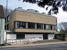
The former Mathematical Institute of Oxford University is at the lower end of the road on the east side. Opposite Keble Road is St Giles' Church, built in 1120 and consecrated in 1200. Further north are the Denys Wilkinson Building (astrophysics) and the prominent 1960s Thom Building of the Engineering Science department.
One of the University's former women's colleges, St Anne's College backs onto Banbury Road and another, St Hugh's College, flanks the road further up. Kellogg College and Wycliffe Hall, which are also part of the university are situated on Banbury Road, near to the junction with Bevington Road. The Independent Sixth Form of d'Overbroeck's College is in the Swan Building at 111 Banbury Road.
The Banbury Road Medical Centre is a National Health Service facility at 172 Banbury Road.[3]
BBC Oxford is also based on Banbury Road and is home to the local televised news output and BBC Radio Oxford. In early 1970 the BBC Oxford studios were actually located further down at 242-254 Banbury Road (now a branch of Marks & Spencer), but were later moved to 269 in 1989 as local media services within BBC Oxford expanded.
People
Famous residents include the lexicographer James Murray who produced the first Oxford English Dictionary (a blue plaque now marks the site) and the zoologist Desmond Morris, author of The Naked Ape.
The artist Paul Nash (1889–1946) lived at 106 Banbury Road, marked with an Oxfordshire Blue Plaque.[4][5]
Jesse Elliston, the proprietor of what became Oxford's leading department store, Elliston & Cavell, died in the Banbury Road in 1853 at the age of only 47.
Adjoining roads in North Oxford
- Bardwell Road
- Beech Croft Road
- Belbroughton Road
- Bevington Road
- Canterbury Road
- Five Mile Drive
- Keble Road
- Lathbury Road
- Linton Road
- Lonsdale Road
- Marston Ferry Road
- Moreton Road
- Norham Gardens
- Norham Road
- North Parade
- Park Town
- Parks Road
- Rawlinson Road
- South Parade
- Staverton Road
- St Giles'
- St Margaret's Road
- Victoria Road
- Woodstock Road
Gallery
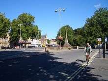
 The southern end of Banbury Road (right) and Woodstock Road (left) from the north end of St Giles'.
 The Denys Wilkinson Building from the Banbury Road on the corner with Keble Road, looking north with the Thom Building in the background.
 Kellogg College at 62 Banbury Road.
 Offices on Banbury Road in Summertown.
 37 Banbury Road, St Anne's College, a typical Gothic North Oxford house, designed by Frederick Codd in 1866.[6]
 Oxford University Computing Services building on Banbury Road.
 The former Mathematical Institute, near the southern end of Banbury Road.
See also
- Acland Hospital
- Norham Manor estate
References
- ↑ "Banbury Road". UK: Oxford History. Retrieved 21 September 2014. External link in
|publisher=(help) - ↑ Blue Plaque marks home of first OED Editor, Blueprint: The newsletter of the University of Oxford, 21 November 2002.
- ↑ Banbury Road Medical Centre, Oxfordshire NHS, UK.
- ↑ "Paul Nash (1889–1946) Artist, 106 Banbury Road, Oxford". UK: Oxfordshire Blue Plaques Board. Retrieved 21 September 2014.
- ↑ "Paul Nash 1889–1946 artist lived here 1940–1946". Open Plaques. Retrieved 21 September 2014.
- ↑ Hinchcliffe, p.217.
Bibliography
- Hinchcliffe, Tanis, North Oxford. New Haven & London: Yale University Press, 1992. ISBN 0-300-05184-0.
Coordinates: 51°46′53″N 1°15′59″W / 51.78133°N 1.26652°W