Victoria Peak
| Victoria Peak (Chinese) 太平山 | |
|---|---|
 Summit of Victoria Peak | |
| Highest point | |
| Elevation | 552 m (1,811 ft) |
| Coordinates | 22°16′31.69″N 114°8′37.78″E / 22.2754694°N 114.1438278°ECoordinates: 22°16′31.69″N 114°8′37.78″E / 22.2754694°N 114.1438278°E |
| Geography | |
| Location |
|
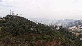
Victoria Peak (Chinese: 太平山, or previously Chinese: 扯旗山) is a mountain in the western half of Hong Kong Island. It is also known as Mount Austin, and locally as The Peak. With an elevation of 552 m (1,811 ft), it is the highest mountain on Hong Kong island, ranked 31 in terms of elevation in the Hong Kong Special Administrative Region (Tai Mo Shan is the highest point in the Hong Kong Special Administrative Region with an elevation of 957 m).
The summit is occupied by a radio telecommunications facility and is closed to the public. However, the surrounding area of public parks and high-value residential land is the area that is normally meant by the name The Peak. It is a major tourist attraction that offers views over Central, Victoria Harbour, Lamma Island and the surrounding islands.
History


As early as the 19th century, the Peak attracted prominent European residents because of its panoramic view over the city and its temperate climate compared to the sub-tropical climate in the rest of Hong Kong. The sixth Governor of Hong Kong, Sir Richard MacDonnell had a summer residence built on the Peak circa 1868.[1] Those that built houses named them whimsically, such as The Eyrie, and the Austin Arms.
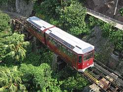
These original residents reached their homes by sedan chairs, which were carried up and down the steep slope of Victoria Peak. This limited development of the Peak until the opening of the Peak Tram funicular in 1888.[1][2]
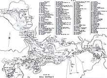
The boost to accessibility caused by the opening of the Peak Tram created demand for residences on the Peak. Between 1904 and 1930, the Peak Reservation Ordinance designated the Peak as an exclusive residential area reserved for non-Chinese. They also reserved the Peak Tram for the use of such passengers during peak periods. The Peak remains an upmarket residential area, although residency today is based on wealth.
Climate
| Climate data for Victoria Peak (2004–2016) | |||||||||||||
|---|---|---|---|---|---|---|---|---|---|---|---|---|---|
| Month | Jan | Feb | Mar | Apr | May | Jun | Jul | Aug | Sep | Oct | Nov | Dec | Year |
| Record high °C (°F) | 25.0 (77) |
28.0 (82.4) |
26.9 (80.4) |
28.2 (82.8) |
30.5 (86.9) |
31.2 (88.2) |
32.3 (90.1) |
32.5 (90.5) |
32.0 (89.6) |
29.9 (85.8) |
28.7 (83.7) |
25.5 (77.9) |
32.3 (90.1) |
| Average high °C (°F) | 16.2 (61.2) |
17.5 (63.5) |
19.5 (67.1) |
22.7 (72.9) |
25.8 (78.4) |
27.3 (81.1) |
28.4 (83.1) |
28.5 (83.3) |
27.8 (82) |
25.4 (77.7) |
22.0 (71.6) |
17.9 (64.2) |
23.2 (73.8) |
| Daily mean °C (°F) | 13.2 (55.8) |
14.6 (58.3) |
16.6 (61.9) |
20.1 (68.2) |
23.3 (73.9) |
25.0 (77) |
25.8 (78.4) |
25.6 (78.1) |
24.9 (76.8) |
22.5 (72.5) |
19.1 (66.4) |
15.0 (59) |
20.5 (68.9) |
| Average low °C (°F) | 10.9 (51.6) |
12.4 (54.3) |
14.5 (58.1) |
18.2 (64.8) |
21.5 (70.7) |
23.4 (74.1) |
23.9 (75) |
23.8 (74.8) |
23.1 (73.6) |
20.7 (69.3) |
17.3 (63.1) |
12.8 (55) |
18.5 (65.3) |
| Record low °C (°F) | −1.0 (30.2) |
4.5 (40.1) |
4.9 (40.8) |
9.4 (48.9) |
13.4 (56.1) |
17.9 (64.2) |
19.8 (67.6) |
20.8 (69.4) |
18.1 (64.6) |
12.4 (54.3) |
6.3 (43.3) |
3.5 (38.3) |
−1.0 (30.2) |
| Average precipitation mm (inches) | 36.6 (1.441) |
31.1 (1.224) |
73.6 (2.898) |
141.4 (5.567) |
312.3 (12.295) |
480.3 (18.909) |
372.1 (14.65) |
377.3 (14.854) |
247.1 (9.728) |
92.9 (3.657) |
44.8 (1.764) |
32.9 (1.295) |
2,242.4 (88.283) |
| Source: Hong Kong Observatory[3] | |||||||||||||
Ecology
The Peak is home to many species of birds, most prominently the black kite, and numerous species of butterflies.
Tourism

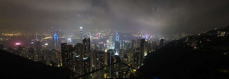
With some seven million visitors every year, the Peak is a major tourist attraction of Hong Kong.[4] It offers spectacular views of the city and its waterfront. The viewing deck also has coin-operated telescopes that the visitors can use to enjoy the cityscape. The number of visitors led to the construction of two major leisure and shopping centres, the Peak Tower and the Peak Galleria, situated adjacent to each other.
The Peak Tower incorporates the upper station of the Peak Tram, the funicular railway that brings passengers up from the St. John's Cathedral in Hong Kong's Central district, whilst the Peak Galleria incorporates the bus station used by the Hong Kong public buses and green minibuses on the Peak. The Peak is also accessible by taxi and private car via the circuitous Peak Road, or by walking up the steep Old Peak Road from near the Zoological Botanical Gardens. The nearest MTR station is Central.[5]
Victoria Peak Garden is located on the site of Mountain Lodge, the Governor's old summer residence, and is the closest publicly accessible point to the summit. It can be reached from Victoria Gap by walking up Mount Austin Road, a climb of about 150 metres (490 ft). Another popular walk is the level loop along Lugard Road, giving good views of Hong Kong's Central district and Kowloon, and then returning via Harlech Road, encircling the summit at the level of the Peak Tower.[6]
There are several restaurants on Victoria Peak, most of which are located in the two shopping centres. However, the Peak Lookout Restaurant, is housed in an older and more traditional building which was originally a spacious house for engineers working on the Peak Tramway. It was rebuilt in 1901 as a stop area for sedan chairs, but was re-opened as a restaurant in 1947.
In addition to being a major tourist attraction for Hong Kong, The Peak is also the summit of Hong Kong's property market. At the peak of The Peak, properties are more expensive than anywhere else in the world. Most of the super-rich in Hong Kong – including Cheung Kong (Holdings) chairman Li Ka-shing and the Kwok brothers of Sun Hung Kai Properties – live in detached houses in Island South or The Peak. In May 2010 a house at Barker Road (where Hong Kong's most expensive residential buildings are located) sold for HK$1.8 billion. At HK$68,228 per square foot, it is the most expensive location in the world. The buyer is Martin Lee, the son of Hong Kong billionaire Lee Shau-kee. On 12 January 2014, a Barker Road property sold at over HK$100,000 (US$13,000) per square foot for HK$690 million.[7]
Official residences
The Peak is home to a few other key officials in Hong Kong:
- 19 Severn Road – residence of the Secretary for Justice
- Victoria House and Victoria Flats at 15 Barker Road – residence of the Chief Secretary for Administration
- Headquarters House 11 Barker Road – residence of the Commander of PLA Forces in Hong Kong and former home of the Commander-in-Chief of British Forces
- Chief Justice's House 19 Gough Hill Road – residence of the Chief Justice of the Court of Final Appeal
Alternative names
| Name | Cantonese (Jyutping) | Hong Kong Hakka | Etymology |
|---|---|---|---|
| 太平山頂 | Taai3peng4saan1 Deng2 | Tai4piang2san1 Dang3 | Literally "pacific mountain peak" or "mountain peak of great peace" |
| 山頂 | Saan1 Deng2 | San1 Dang3 | Literally "mountain top"; corresponds to the English name "The Peak" |
| 扯旗山 | Ce2kei4 Saan1 | Ca3ki2 San1 | Literally means "flag-raising mountain" |
| 爐峰 | Lou4 Fung1 | Lu2 Fung1 | Literally means "furnace peak" |
| 維多利亞山 | Wai4do1lei6aa3 Saan1 | Vui2do1li1a1 San1 | A phonetic transliteration of the English name "Victoria Peak" |
| 柯士甸山 | O1si6din1 Saan1 | Ko1si3tien1 San1 | A phonetic transliteration of the English name "Mount Austin" |
Cityscape
Meteorological
| Climate data for The Peak(2003–2016) | |||||||||||||
|---|---|---|---|---|---|---|---|---|---|---|---|---|---|
| Month | Jan | Feb | Mar | Apr | May | Jun | Jul | Aug | Sep | Oct | Nov | Dec | Year |
| Record high °C (°F) | 25 (77) |
28 (82) |
26.9 (80.4) |
28.2 (82.8) |
30.5 (86.9) |
31.2 (88.2) |
32.3 (90.1) |
32.5 (90.5) |
32 (90) |
29.6 (85.3) |
28.7 (83.7) |
25.5 (77.9) |
32.5 (90.5) |
| Average high °C (°F) | 16.3 (61.3) |
17.7 (63.9) |
19.6 (67.3) |
22.6 (72.7) |
25.7 (78.3) |
27.2 (81) |
28.3 (82.9) |
28.5 (83.3) |
27.8 (82) |
25.3 (77.5) |
22 (72) |
17.8 (64) |
23.23 (73.85) |
| Daily mean °C (°F) | 13.2 (55.8) |
14.7 (58.5) |
16.7 (62.1) |
20 (68) |
23.3 (73.9) |
24.9 (76.8) |
25.7 (78.3) |
25.7 (78.3) |
24.9 (76.8) |
22.4 (72.3) |
19.1 (66.4) |
14.8 (58.6) |
20.45 (68.82) |
| Average low °C (°F) | 10.9 (51.6) |
12.6 (54.7) |
14.5 (58.1) |
18 (64) |
21.5 (70.7) |
23.3 (73.9) |
23.9 (75) |
23.8 (74.8) |
23.1 (73.6) |
20.6 (69.1) |
17.8 (64) |
12.7 (54.9) |
18.56 (65.37) |
| Record low °C (°F) | −1 (30) |
4.4 (39.9) |
4.9 (40.8) |
9.4 (48.9) |
13.4 (56.1) |
17.9 (64.2) |
19.8 (67.6) |
20.5 (68.9) |
18.1 (64.6) |
12.4 (54.3) |
6.3 (43.3) |
3.5 (38.3) |
−1 (30) |
| Average precipitation mm (inches) | 20.4 (0.803) |
31.6 (1.244) |
66.3 (2.61) |
133.1 (5.24) |
322.3 (12.689) |
491 (19.33) |
381.5 (15.02) |
369.1 (14.531) |
252.5 (9.941) |
59.5 (2.343) |
37.7 (1.484) |
34.4 (1.354) |
2,199.4 (86.589) |
| Average rainy days (≥ 0.5 mm) | 5 | 9.1 | 9.8 | 10.9 | 14.4 | 18.8 | 17 | 15.3 | 13.4 | 6.4 | 5.5 | 5.7 | 131.3 |
| Source: Hong Kong Observatory[8][9][10][11] | |||||||||||||
See also
- List of buildings, sites and areas in Hong Kong
- List of mountains, peaks and hills in Hong Kong
- List of places named after Queen Victoria
- The Peak Hotel, a hotel located on Victoria Peak from 1888 to 1936
- Peak Reservation Ordinance
- Tourism in Hong Kong
- Hiking route to Victoria peak[12]
References
- 1 2 "The Peak History". The Peak. Archived from the original on 7 March 2007. Retrieved 14 March 2007.
- ↑ "Peak Tram History". The Peak Hong Kong. Archived from the original on 20 February 2007. Retrieved 13 March 2007.
- ↑ "Monthly Means of Meteorological Elements for Victoria Peak, 2004-2016". Hong Kong Observatory. Retrieved February 8, 2017.
- ↑ DeWolf, Christopher "9 Hong Kong tourist traps – for better or worse" CNN Go. 27 October 2010. Retrieved 3 March 2012.
- ↑ "Hong Kong: 10 Things to Do — 1. Victoria Peak - TIME". content.time.com. Retrieved 4 November 2016.
- ↑ http://www.thepeak.com.hk/full/en/nature.php
- ↑ "Hutchison Whampoa completes HK$690m house sale on Peak" South China Morning Post 13 Jan 2014
- ↑ "山頂氣象要素月平均值 (2004-2015)". Hong Kong Observatory. Retrieved 4 February 2016.
- ↑ "山頂冷熱天氣及雨量統計 (2004-2015)". Hong Kong Observatory. Retrieved 4 February 2016.
- ↑ "山頂月最高氣溫 (攝氏度)". Hong Kong Observatory. Retrieved 17 March 2016.
- ↑ "山頂月最低氣溫 (攝氏度)". Hong Kong Observatory. Retrieved 17 March 2016.
- ↑ http://www.discoverhongkong.com/ca/see-do/great-outdoors/hikes/peak-circle-walk.jsp
External links
| Wikimedia Commons has media related to Victoria Peak. |

