Southwest Finland
| Southwest Finland Varsinais-Suomen maakunta Egentliga Finlands landskap | ||
|---|---|---|
| Region | ||
| ||
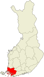 Finland Proper on a map of Finland | ||
| Country | Finland | |
| Historical province | Finland Proper | |
| Area | ||
| • Total | 10,910.05 km2 (4,212.39 sq mi) | |
| Population (2011) | ||
| • Total | 470,880 | |
| • Density | 43/km2 (110/sq mi) | |
| Time zone | EET (UTC+2) | |
| • Summer (DST) | EEST (UTC+3) | |
| ISO 3166 code | FI-19 | |
| NUTS | 183 | |
| Regional bird | Jackdaw | |
| Regional fish | Baltic herring | |
| Regional flower | Oak | |
| Website | varsinais-suomi.fi | |
Southwest Finland, also known in English as Finland Proper[1] (Finnish: Varsinais-Suomi, Swedish: Egentliga Finland) is the region in south-western Finland that borders the regions of Satakunta and Tavastia Proper. Its capital and biggest city is Turku with 182,000 inhabitants and metro population of 316,000. Turku was also the most important city in Finland from its establishment around the 13th century until the 1840s.
The area comprising the southwest is largely the same as the historical province of Finland Proper, so named because it is the original home of the tribe known as the Finns. 5.7% of population of the region speaks Swedish natively.
Origin of the name
The name of Finland Proper has a historical function. In historic times, in the area of the present southern Finland lived three tribes, which were the Finns, the Tavastians and the Karelians. The southwestern part of the country, the province where the Finns lived, was called simply Finland (Finnish: Suomi). In the 17th century the name began to be used to refer to the whole land and a specified name for the lesser Finland was required. The first notes Fennigia specialiter dicta and Fennigia presse dicta were recorded in Latin in the 1650s and the Swedish Finland för sig sielft and Egenteliga Finland later in the 18th century the modern form Egentliga Finland being in official use at the end of the century. The Finnish term Varsinais-Suomi became established only around the 1850s.[2]
Historical provinces
Municipalities

The region of Southwest Finland is made up of 27 municipalities, of which 11 have city status (marked in bold).
|
Åboland–Turunmaa sub-region: Salo sub-region: Turku sub-region: |
Loimaa sub-region: Vakka-Suomi sub-region:
|
Politics
Results of the Finnish parliamentary election, 2015 in Finland Proper:
- National Coalition Party 21.0%
- Finns Party 19.3%
- Centre Party 16.2%
- Social Democratic Party 15.5%
- Left Alliance 10.3%
- Green League 8.7%
- Swedish People's Party 5.0%
- Christian Democrats 2.4%
- Other parties 1.6%
Heraldry
The region uses the coat of arms of the historical province of Finland Proper.
Image gallery
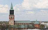 Turku Cathedral dating back to the 13th century is Finland's national shrine and one of Finland's most recognized buildings
 A typical view from Turku Archipelago, the largest archipelago (by number of islands) in the world
 Louhisaari Manor in Masku was the birthplace of Finland's marshal and president Mannerheim
 The Old Castle of Lieto and rural landscape
- Naantali Harbour with the former Bridgettine monastery church in the background
 A general view of the City of Turku from the tower of the cathedral
- Bengtskär lighthouse in Kimitoön is the highest one in the Nordic countries
- Nautelankoski Rapids in River Aura in Lieto
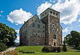 The medieval Turku Castle on the banks of River Aura is one of the most influential buildings in Finnish history
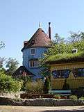
- A limestone quarry in Pargas
 Historical salt warehouses in Uusikaupunki town centre
- A bridge from 1850 in Taivassalo
- Korpo Church; there are 25 remaining medieval churches in the region
 Luostarinmäki Handicrafts Museum is an 18th-century district of the city that survived the Great Fire of Turku which burnt down four-fifths of the city in 1827
 May Day celebrations in Turku centre; the Arts Museum on the top of Street Aurakatu
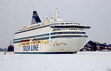
 Traffic connections between islands are mostly served with ferries in the archipelago

- A street view in Turku; old wooden houses and modern block of flats
- Marshland in Loimaa
 Naantali Old Town has been well preserved
 The functionalistic Paimio Sanatorium by Alvar Aalto
- A silo in Salo; the region still has a strong agricultural feel

 Ruins of the medieval Kuusisto Bishops' Castle demolished in 1528 during the Protestant Reformation in Kaarina
 Pargas Old Town
- River Paimionjoki and rural landscape in Marttila
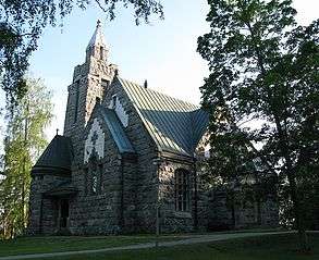
- Teijo Church in Salo is the smallest stone church in Finland

Notes
- ↑ The regional council of the region uses the name "Southwest Finland". Despite this, the Language Planning Department of Finland recommends the name "Varsinais-Suomi" as suggested in the statement by the Interior Ministry of Finland in 1988. The Institute for Languages of Finland lists the official English name as "Varsinais-Suomi".
- ↑ Suomalainen paikannimikirja. Jyväskylä: Gummerus. 2007. ISBN 978-951-593-976-0.
- ↑ "Ennakkoväkiluku sukupuolen mukaan alueittain, maaliskuu.2016" (in Finnish). Statistics Finland. Retrieved 31 March 2016.
External links
| Wikimedia Commons has media related to Finland Proper. |
![]() Finland Proper travel guide from Wikivoyage
Finland Proper travel guide from Wikivoyage
Coordinates: 60°30′N 22°45′E / 60.500°N 22.750°E
