Novo Goražde
| Novo Goražde Ново Горажде | |
|---|---|
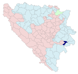
 Location of Novo Goražde within Bosnia and Herzegovina | |
| Country | Bosnia and Herzegovina |
| Entity | Republika Srpska |
| Area | |
| • Total | 119 km2 (46 sq mi) |
| Population (2013 census) | |
| • Total | 3,391 |
| • Density | 28,5/km2 (740/sq mi) |
| Time zone | CET (UTC+1) |
| • Summer (DST) | CEST (UTC+2) |
| Area code(s) | 58 |
Novo Goražde (Serbian Cyrillic: Ново Горажде)[1], commonly referred to as Kopači , also known as Ustiprača, is a municipality of Republika Srpska in Bosnia and Herzegovina. It was split from the pre-existing municipality of Goražde and given to Republika Srpska by the Dayton treaty. The other part of the pre-war municipality is now in the Federation of Bosnia and Herzegovina.
The Bosnian Eastern Railway from Sarajevo to Uvac and Vardište was built through Ustiprača during the Austro-Hungarian rule in Bosnia and Herzegovina. The name of the railway station was Ustiprača-Goražda at that time. Construction of the line started in 1903. It was completed in 1906, using the 760 mm (2 ft 5 15⁄16 in) track gauge. With the cost of 75 million gold crowns, which approximately translates to 450 thousand gold crowns per kilometer, it was one of the most expensive railways in the world built by that time.[2] The extensions were built from Uvac to Priboj, and from Vardište to Belgrade in 1928. In 1939, the railway station Ustiprača became a junction railway station to destinations of Sarajevo, Belgrade and Foča, after a branch line from Ustiprača to Foča had been built.[3] The entire line was closed down in 1978, and dismantled afterwards.[2]
Gallery
 Ustiprača train station after opening in 1906
 Church of Saint George in the village of Sopotnica, Novo Goražde
- Road entrance to Novo Goražde
 Cemetery in Novo Goražde
References
- ↑ "Општина Ново Горажде". www.novogorazde.rs.ba.
- 1 2 "Narrow-gauge railway in Višegrad". visegradturizam.com. Tourist organization of Višegrad. Retrieved 18 September 2016.
- ↑ "Uskotračne željeznice - Grafikoni" [Narrow-gauge railways - Graphs]. zeljeznice.net (in Croatian). Retrieved 18 September 2016. (Registration required (help)).
Coordinates: 43°41′28″N 19°05′13″E / 43.691°N 19.087°E
| Wikimedia Commons has media related to Novo Goražde. |