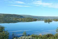
Ustevatn
| Ustevatn | |
|---|---|
 | |
| Location | Hol (Buskerud) |
| Coordinates | 60°29′6″N 8°0′46″E / 60.48500°N 8.01278°E / 60.48500; 8.01278Coordinates: 60°29′6″N 8°0′46″E / 60.48500°N 8.01278°E / 60.48500; 8.01278 |
| Basin countries | Norway |
| Surface area | 12.40 km2 (4.79 sq mi) |
| Shore length1 | 31.26 km (19.42 mi) |
| Surface elevation | 985 m (3,232 ft) |
| References | NVE |
| 1 Shore length is not a well-defined measure. | |
Ustevatn is a lake in the municipality of Hol in Buskerud county, Norway. The main inflow is on the west side of the lake provided by Ustekveikja, which originates from the area around Finse in Hordaland. Norwegian National Road 7 runs along the north side of the lake. Bergen line railway has stations at Ustaoset and Haugastøl.[1] [2] [3]
See also
References
This article is issued from
Wikipedia.
The text is licensed under Creative Commons - Attribution - Sharealike.
Additional terms may apply for the media files.