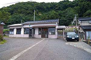
Uramoto Station
Uramoto Station 浦本駅 | |
|---|---|
 Uramoto Station in September 2011 | |
| Location |
Mawaki, Itoigawa-shi, Niigata (新潟県糸魚川市間脇) Japan |
| Operated by |
|
| Line(s) | ■ Nihonkai Hisui Line |
| Platforms | 2 side platforms |
| History | |
| Opened | 28 January 1950 |
| Traffic | |
| Passengers (FY2015) | 9 daily |
| Location | |
 Uramoto Station Location within Japan | |
Uramoto Station (浦本駅 Uramoto-eki) is a railway station in Itoigawa, Niigata, Japan, operated by Echigo Tokimeki Railway.
Lines
Uramoto Station is served by the Nihonkai Hisui Line, and is 28.3 kilometers from the starting point of the line at Ichiburi and 322.8 kilometers from Maibara Station.
Station layout
The station consists of two opposed side platforms on an embankment, with the station building at ground level. The station is unattended.
Platforms
| Station side | ■ Nihonkai Hisui Line | for Naoetsu |
| Opposite side | ■ Nihonkai Hisui Line | for Itoigawa |
Adjacent stations
| « | Service | » | ||
|---|---|---|---|---|
| Nihonkai Hisui Line | ||||
| Kajiyashiki | Local | Nō | ||
History
The station opened on 28 January 1950, as part of the Japan National Railways (JNR). From 14 March 2015, with the opening of the Hokuriku Shinkansen extension from Nagano to Kanazawa, local passenger operations over sections of the Shinetsu Main Line and Hokuriku Main Line running roughly parallel to the new shinkansen line were reassigned to third-sector railway operating companies.[1] From this date, Uramoto Station was transferred to the ownership of the third-sector operating company Echigo Tokimeki Railway.
Passenger statistics
In fiscal 2015, the station was used by an average of 9 passengers daily (boarding passengers only).[2]
Surrounding area
- Uramoto fishing port
- Uramoto Post Office
- Uramoto Elementary School
See also
References
- ↑ Osano, Kagetoshi (March 2015). 北陸新幹線並行在来線各社の姿 [Guide to companies operating conventional lines alongside the Hokuriku Shinkansen]. Tetsudō Daiya Jōhō Magazine (in Japanese). Vol. 44 no. 371. Japan: Kōtsū Shimbun. pp. 28–33.
- ↑ 平成27年度の乗車状況(平成27年4月1日~平成28年3月31日)[各駅の1日平均乗車人員 [Station passenger figures (Fiscal 2015)] (in Japanese). Japan: Echigo Tokimeki Railway Company. 2016. Archived from the original on 14 August 2016. Retrieved 14 August 2016.
External links
- Train timetables (in Japanese)
Coordinates: 37°04′27″N 137°56′22″E / 37.0741°N 137.9394°E