U.S. Route 127
| |
|---|---|
 | |
| Route information | |
| Auxiliary route of US 27 | |
| Length: | 758 mi[1] (1,220 km) |
| Existed: | 1926 – present |
| Major junctions | |
| South end: |
|
|
| |
| North end: |
|
| Location | |
| States: | Tennessee, Kentucky, Ohio, Michigan |
| Highway system | |
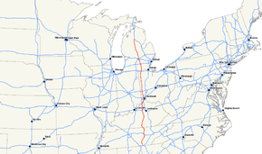
U.S. Route 127 (US 127) is a 758-mile-long (1,220 km) north–south U.S. Highway in the eastern half of the United States. The southern terminus of the route is at US 27 in Chattanooga, Tennessee. The northern terminus is at Interstate 75 (I-75) near Grayling, Michigan. Since 1987, it has been the core of the annual World's Longest Yard Sale, also known as the Highway 127 Corridor Sale (127 Yard Sale), which now stretches 690 miles (1,110 km) from Addison, Michigan, to Gadsden, Alabama. The sale, held every August, was started to demonstrate that the older U.S. Highway System has something to offer that the Interstate Highway System does not.[2]
In Michigan, US 127 tripled in length in 2002 at the expense of its parent, US 27.
Route description
Tennessee
In Tennessee, US 127 traverses rural areas of the Cumberland Plateau in eastern Middle Tennessee and western East Tennessee, passing southward through the cities of Jamestown and Crossville, then follows the Sequatchie Valley, passing through the cities of Pikeville and Dunlap. Near Dunlap the route turns southeastward to cross Walden Ridge, passing Signal Mountain and ending at its junction with US 27 in the northern Chattanooga suburb of Red Bank.
Kentucky
In Kentucky, US 127 is cosigned with US 42 through Cincinnati's Northern Kentucky suburbs until five miles (8.0 km) east of Warsaw, then passes south through Owenton. This was the road driven by Buddy Rich when he wrote "Blue Grass makes me Blue" in 1947.[3] At the state capital of Frankfort, it becomes a four-lane highway, then skirts Lawrenceburg, Harrodsburg, and Danville. It enters the hilly Knobs Region at Junction City, where it becomes a two-lane route, and continues through Hustonville, crossing the drainage divide between the Kentucky and Green river watersheds and roughly following the scenic upper Green River valley through Casey County, crossing the river at Liberty. South of Dunnville it climbs onto the Eastern Pennyroyal Plateau and cuts through Russell Springs and Jamestown. It crosses Wolf Creek Dam, which creates Lake Cumberland. It runs very briefly with KY 90 north of Albany and crosses into Tennessee at Static. The new route through Clinton County includes a bypass west of Albany; the original plan for a more direct eastern route was abandoned because of historic and scenic concerns. In the county US 127 runs through sinkhole plains along the escarpment that marks the western edge of the Cumberland Plateau, creating scenic views.
Ohio
US 127 serves several cities and rural communities along the extreme western edge of Ohio, including Cincinnati, New Miami, Seven Mile, Somerville, Eaton, Greenville, Celina, Van Wert, Paulding and Bryan. In Cincinnati, it shares a short concurrency with its parent route, US 27, along with US 42. From there, it heads north through Fairfield and Hamilton. The highway is a four-lane, divided bypass around Greenville. US 127 crosses the Ohio Turnpike near West Unity, but does not intersect with it. It also joins with US 36 for about 5 miles (8 km). The first city US 127 enters after leaving Kentucky is Cincinnati. The last city that US 127 goes through before reaching Michigan is Bryan.
Except for Defiance County, US 127 passes through the county seats of all nine counties in Ohio that share a border with Indiana. It also traverses a portion of Fulton County before entering Michigan.
In total, US 127 traverses 194.2 miles (312.5 km) across Ohio.
| Browse numbered routes | ||||
|---|---|---|---|---|
| ← | OH | SR 127 | ||
Michigan

In Michigan, US 127 runs from the Ohio border south of Hudson north to the junction with I-75, four miles (6.4 km) south of Grayling, a distance of 212.12 miles (341.37 km).[4][5]
The highway is the primary route connecting Lansing and central Michigan to Northern Michigan and the Mackinac Bridge; it serves the cities of Jackson, Lansing, and Clare. From the south side of Jackson northerly, it is mostly a four-lane freeway, except for the notable exception of a 16-mile (26 km) stretch from north of St. Johns to just south of Ithaca, where access to the road is not limited.
Prior to 2002, US 127 ran from I-69 north of East Lansing southerly to the Ohio border near Hudson, a total of 83 miles (134 km).[6][7] From the Ohio border until Jackson, the highway follows the course (with minor deviations) of the Michigan Meridian used to survey Michigan in the early 19th century. That stretch is generally named Meridian Road.[8]
A proposed I-73 would incorporate US 127 between Jackson and Grayling.[9]
History
Southern terminus
US 127 originally terminated at Toledo when it was commissioned in 1926. At that time, the southern portion ran from Somerset to Toledo along the route of present-day U.S. Route 223. In 1930 the southern terminus moved to Cincinnati, and in 1958 it was extended to its present southern terminus at Chattanooga.[10]
Northern terminus
The northern terminus of US 127 was in or near Lansing, Michigan, from its inception in 1926 to 2002. In 2002, the terminus was moved to an intersection with I-75 south of Grayling in Crawford County, Michigan, replacing all of US 27 north of Lansing.[6][7]
Major intersections
- Tennessee
-
 US 27 in Chattanooga
 -
 US 70 in Crossville
 -
 US 70N in Crossville
 -
 I‑40 in Crossville
 - Kentucky
-
 US 150 in Danville. The highways travel concurrently through Danville.
 -
 US 68 northeast of Harrodsburg
 -
 US 62 in Lawrenceburg
 -
 I‑64 in Frankfort
 -
 US 60 in Frankfort
 -
 US 421 in Frankfort. The highways travel concurrently through Frankfort.
 -
 I‑71 in Glencoe
 -
 US 42 north-northeast of Glencoe. The highways travel concurrently to .
 -

 I‑71 / I‑75 in Florence
 -
 US 25 in Florence. The highways travel concurrently to the Ohio state line.
 -
 I‑275 in Crestview Hills
 -

 I‑71 / I‑75 in Fort Mitchell
 -

 I‑71 / I‑75 in Covington
 - Ohio
-

 US 27 / US 52 in Cincinnati. The highways travel concurrently through Cincinnati.
 -

 I‑75 / US 50 in Cincinnati
 -

 I‑75 / US 50 in Cincinnati
 -
 US 22 in Cincinnati
 -
 I‑74 in Cincinnati
 -
 I‑75 in Cincinnati
 -
 I‑275 on the Pleasant Run–Mount Healthy Heights–Forest Park line.
 -
 US 35 in Eaton
 -
 I‑70 exit 10 Eaton, OH (4 miles south)
 -
 US 40 west of Lewisburg
 -
 US 36 west-northwest of Jaysville. The highways travel concurrently to Greenville.
 -
 US 33 southeast of Rockford
 -

 US 30 / US 224 in Van Wert. US 127/US 224 travels concurrently to north-northeast of Van Wert.
 -
 US 24 east of Cecil
 -
 US 6 south of Bryan
 -
 US 20 east of Alvordton. The highways travel concurrently to west of Fayette.
 - Michigan
-
 US 223 southeast of Somerset
 -
 US 12 east of Somerset
 -
 I‑94 northeast of Jackson. The highways travel concurrently to north-northwest of Jackson.
 -

 I‑96 / I‑496 at Michigan State University south-southeast of Lansing. I-496/US 127 travels concurrently to East Lansing.
 -
 I‑69 north-northwest of East Lansing
 -
 US 10 in Clare. The highways travel concurrently to north-northwest of Clare.
 -
 I‑75 south of Grayling
See also
 U.S. Roads portal
References
- ↑ Droz, Robert V. (April 6, 2006). "Termini and Lengths in Miles". U.S. Highways: From US 1 to (US 830). Self-published. Retrieved November 15, 2006.
- ↑ Burk, Tonja (August 2, 2010). "Update: Vendors open shop early for World's Longest Yard Sale". Knoxville, TN: WBIR-TV. Retrieved August 2, 2010.
- ↑ Kentucky Department of Highways (1948). General Highway Map: Owen County, Kentucky (Map). 1:125,000. Frankfort: Kentucky Department of Highways. Retrieved June 26, 2012.
- ↑ Michigan Department of Transportation & Michigan Center for Shared Solutions and Technology Partnerships (2009). MDOT Physical Reference Finder Application (Map). Michigan Department of Transportation. Retrieved August 4, 2013.
- ↑ Michigan Department of Transportation (2014). Pure Michigan: State Transportation Map (Map). c. 1:975,000. Lansing: Michigan Department of Transportation. §§ G10–N11. OCLC 42778335, 900162490.
- 1 2 Michigan Department of Transportation (2002). Michigan, Great Lakes Great Times: Official Department of Transportation Map (Map). c. 1:918,720. Lansing: Michigan Department of Transportation. §§ G10–L11. OCLC 42778335.
- 1 2 Michigan Department of Transportation (2003). Michigan: Official Department of Transportation Map (Map) (2003–04 ed.). c. 1:918,720. Lansing: Michigan Department of Transportation. §§ G10–L11. OCLC 42778335.
- ↑ Jacobson, Daniel (July–August 1988). "Michigan Meridian and Base Line: A Teaching Formulation for the Secondary School". Journal of Geography. 87 (4): 131–40. ISSN 0022-1341. doi:10.1080/00221348808979779.
- ↑ Office of Planning, Environment, & Realty (June 18, 2012). "High Priority Corridors". National Highway System. Federal Highway Administration. Retrieved June 26, 2012.
- ↑ Sanderson, Dale (November 14, 2009). "End of US Highway 127". US Ends.com. Self-published. Retrieved June 26, 2012.
External links
- 127 Corridor Sale website
- 127 Yard Sale website - Find vendors and rental space providors, create listings, interactive route map, discussion forums
- Endpoints of US highway 127
| Browse numbered routes | ||||
|---|---|---|---|---|
| ← | list | KY 128 | ||
