Twin Falls (Idaho)
| Twin Falls | |
|---|---|
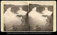
 Stereograph of Twin Falls (ca. 1868-71), prior to the construction of the Twin Falls Dam | |
| Location | East of the city of Twin Falls and the Shoshone Falls |
| Coordinates | 42°35′21″N 114°21′25″W / 42.58917°N 114.35694°WCoordinates: 42°35′21″N 114°21′25″W / 42.58917°N 114.35694°W |
| Type | Block, Plunge |
| Elevation | 3,560 feet (1,090 m) |
| Total height | 200 feet (61 m) |
| Number of drops | 1 |
| Average width | 100 feet (30 m) |
| Watercourse | Snake River |
Twin Falls is a waterfall on the Snake River in the Snake River Canyon in southern Idaho, United States.[1] The falls are located on the border of Jerome and Twin Falls counties, a few miles east of its namesake city, Twin Falls. They are upstream of Pillar Falls and Shoshone Falls and just downstream from Milner Dam.
Water flow over Twin Falls is controlled by the Twin Falls Dam, which is used for irrigation and hydroelectric power generation. The falls were so named because there was originally two parallel falls on the river. However, the Twin Falls Dam altered the falls and permanently diverted the flow of the Snake River from the southern falls, leaving a single waterfall.[2]
See also
References
- ↑ U.S. Geological Survey Geographic Names Information System: Twin Falls
- ↑ Google (18 Jun 2017). "Twin Falls, Idaho (waterfall)" (Map). Google Maps. Google. Retrieved 18 Jun 2017.
External links
![]() Media related to Twin Falls (Idaho) at Wikimedia Commons
Media related to Twin Falls (Idaho) at Wikimedia Commons
This article is issued from
Wikipedia.
The text is licensed under Creative Commons - Attribution - Sharealike.
Additional terms may apply for the media files.