Tukwila International Boulevard station
 Tukwila International Boulevard | |||||||||||
|---|---|---|---|---|---|---|---|---|---|---|---|
| Link light rail station | |||||||||||
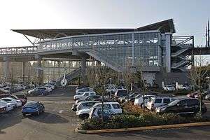 The station and parking lot, viewed from Southcenter Boulevard | |||||||||||
| Location |
15426 35th Avenue S. Tukwila, Washington | ||||||||||
| Coordinates | 47°27′50.7″N 122°17′17″W / 47.464083°N 122.28806°WCoordinates: 47°27′50.7″N 122°17′17″W / 47.464083°N 122.28806°W | ||||||||||
| Owned by | Sound Transit | ||||||||||
| Line(s) | |||||||||||
| Platforms | 2 side platforms | ||||||||||
| Tracks | 2 | ||||||||||
| Connections | King County Metro (RapidRide) | ||||||||||
| Construction | |||||||||||
| Structure type | Elevated | ||||||||||
| Parking | 662 parking spaces[1] | ||||||||||
| Bicycle facilities | Lockers and racks | ||||||||||
| Disabled access | Yes | ||||||||||
| History | |||||||||||
| Opened | July 18, 2009 | ||||||||||
| Traffic | |||||||||||
| Passengers | 2,603 daily boardings (Q1 2017)[2] | ||||||||||
| Services | |||||||||||
| |||||||||||
Tukwila International Boulevard is a light rail station located in Tukwila, Washington. It is situated between the SeaTac/Airport and Rainier Beach stations on the Central Link line, which runs from Seattle–Tacoma International Airport to Downtown Seattle as part of the Link light rail system. The station consists of two elevated side platforms enclosed in a structure northeast of the interchange of State Route 99 and State Route 518 in Tukwila, Washington. It also includes 662 total parking spaces and functions as a park and ride, one of only two on the line.
Tukwila International Boulevard station opened on July 18, 2009, on the first day of Central Link service, and served as the line's terminus until SeaTac/Airport station opened in December 2009. Trains serve the station 20 hours a day on most days; the headway between trains is 6 minutes during peak periods, with less frequent service at other times. Tukwila International Boulevard station is also served by two RapidRide lines and two King County Metro bus routes that connect it to Downtown Seattle, Federal Way, Burien, Renton, Georgetown, and West Seattle.
Location
Tukwila International Boulevard station is located on South 154th Street (Southcenter Boulevard) at the intersection of State Route 518 and State Route 99 (International Boulevard) in southern Tukwila.[3] The highway junction is approximately 2 miles (3.2 km) north of Seattle–Tacoma International Airport and serves as its main entrance,[4] also serving a nearby rental car facility and airport parking lots.[5][6] The station is 1 mile (1.6 km) west of the Westfield Southcenter Mall, a major regional shopping center, and is connected via the RapidRide F Line.[7][8] To the north of the station area is Tukwila's commercial district, featuring ethnic cuisine, including Indian, Chinese, East African and Mexican food.[9][10]
The Tukwila International Boulevard station area consists primarily of single-family homes, with some multi-family residential and commercial along International Boulevard and State Route 518. Within a 1⁄2 mile (0.80 km) radius of the station is a population of 4,155 residents in 2,332 housing units, of which 95 percent are considered "affordable".[5] In 2015, the King County Housing Authority purchased 286 apartments in a building near Tukwila International Boulevard station to preserve their affordable rates for low-income households.[11] The Puget Sound Regional Council describes the area as one dominated by "auto-oriented land uses" leading to "poor pedestrian and bicycle infrastructure that impedes walkability".[5]
The area surrounding the station is split between the cities of SeaTac and Tukwila by International Boulevard, leading to two comprehensive plans for transit-oriented development near the station. The city of SeaTac adopted a redevelopment proposal in 2006 for 42 acres (17 ha) of land west of International Boulevard, desiring mixed-use development to bring an additional 2,600 people daily to the area by 2020.[12] The city of Tukwila adopted an urban renewal plan for the area in 1998 and a comprehensive plan in 2015, both envisioning improved commercial access and additional residential units in the area around the station and on International Boulevard.[13]
History
.jpg)
The earliest proposal for a light rail station near Tukwila came from the Puget Sound Council of Governments in 1986, as part of a north–south line from Lynnwood to Federal Way. The station would have been located along State Route 518 northwest of the Southcenter Mall, between stations at Seattle–Tacoma International Airport and on Interurban Avenue.[14] A regional transit authority (RTA) was formed in the early 1990s to study a regional light rail system, first proposing a $6.7 billion plan in 1995 with an at-grade light rail line on Pacific Highway (later International Boulevard) with stops at South 144th and 158th streets in Tukwila.[15] The proposal was opposed by the Tukwila City Council and rejected by voters in March 1995,[16] leading to a smaller proposal submitted to voters the following year by the RTA.[17] The second proposal, called "Sound Move", selected a station near South 158th Street in Tukwila and was approved by voters in November 1996.[18][19]
The RTA (renamed to Sound Transit) began a series of public hearings in late 1997 to determine the routing of the regional light rail line. Tukwila leaders preferred a route serving the Southcenter Mall that would add six to seven minutes of travel time and $150 million in project costs.[20][21] Ultimately, Sound Transit chose an at-grade line on International Boulevard as their preferred routing in February 1999,[22] which the city argued would interfere with their near-term plans to revamp the street.[23] Ultimately, the board selected a light rail route in November 1999 including International Boulevard through Tukwila and an elevated station at South 154th Street with a park and ride facility.[24][25]
Several weeks before the November 1999 decision, the city of Tukwila proposed an alternate alignment using State Route 599, Interstate 5, and State Route 518 known as the "Tukwila Freeway Route". The alignment would keep light rail off of International Boulevard and serve a station at South 154th Street, but was criticized by business owners for not serving the city's urban center at Southcenter Mall.[25][26] Sound Transit determined that the new proposal was announced too late to be examined in the initial environmental impact statement in November 1999, but approved a formal review in May 2000.[27] On February 8, 2001, the Sound Transit Board revised the preferred alternative for the Central Link light rail project by adding the Tukwila Freeway Route to the alignment.[28] Budgetary problems with the Central Link light rail project lead to the shortening of the line in late 2001 by Sound Transit, terminating at the South 154th Street park and ride instead of Seattle–Tacoma International Airport.[29] The new terminus was adopted in November 2001, allowing for construction to begin on the light rail system.[30]
In June 2002, the Tukwila City Council rejected a memorandum of agreement with Sound Transit that would have expedited processing of light rail permits issued by the city.[31] Although the city council supported the Tukwila Freeway Route in 2001, the lack of service to Southcenter drove the rejection despite lobbying from elected officials in other cities.[32] Despite initial fears that the decision would jeopardize federal funding for the light rail project, Sound Transit was granted its application for a $500 million commitment later that month.[33] The city council approved expedited permitting in 2004 after requesting Sound Transit increase the parking capacity at the future South 154th Street station and park and ride to 600 stalls, at an additional cost of $5 million.[34][35]
.jpg)
The station, officially named Tukwila International Boulevard in January 2005,[36] began construction in 2005. A $231.7 million construction contract for the station and 4.22 miles (6.79 km) of elevated guideway towards Rainier Beach station was awarded to PCL Construction in March 2005.[37][38] Site clearing at the future station, which was previously an airport parking lot operated by Ajax,[39] began the following month.[40] By late November, the first elevated guideway segment was completed and column erection at the station was near completion.[41][42] Formation of the mezzanine and main structural elements of the station were completed from late 2005 to early 2007.[43] The station and segment through Tukwila were declared substantially complete by PCL Construction in March 2008 and all major work at the station was finished by late June.[44]
The station and its 600-space park and ride opened on July 18, 2009, the first day of Central Link service, and became the line's southern terminus.[45] The following week, shuttle bus service to Seattle–Tacoma International Airport began operating from the station every 10 to 15 minutes to the airport's main terminal.[46] The shuttle service was suspended after the opening of SeaTac/Airport station on December 19, 2009, replacing Tukwila as the new southern terminus of the line.[47]
Station layout
| Platform level |
||
| Northbound | ← Central Link toward University of Washington (Rainier Beach) | |
| Southbound | → Central Link toward Angle Lake (SeaTac/Airport) → | |
| Mezzanine | Ticket vending machines | |
| Street level | Entrance/Exit, bus bays, kiss and ride, park and ride | |
Tukwila International Boulevard station consists of two side platforms elevated 51 feet (16 m) above ground level and connected to street level by a mezzanine and a series of escalators, stairs and elevators.[3] Designed by David Hewitt and his Seattle-based architecture firm,[48] the station's architecture includes elements meant to evoke "airplanes and liftoff", including an angular roof that is shaped like the wings of an airplane.[49] At platform level, the station features large glass windows with views of Tukwila, Mount Baker, and the Sea-Tac airport control tower.[3][50] Below the platform and mezzanine levels is a bus station and kiss and ride area that faces a 600-stall, free park and ride (which includes an auxiliary lot located across Southcenter Boulevard). Since 2013, 62 additional parking spaces have been leased from a nearby garage;[51] in 2016, the main lot began a permit parking trial that reserves spaces for registered carpool vehicles for a monthly fee of $5.[52] Sound Transit also offers a bicycle parking station with 8 secured spots,[53] as well as racks for temporary use.[54]
Art
Tukwila International Boulevard station also houses four art installations as part of the "STart" program, which allocates a percentage of project construction funds to art projects to be used in stations.[55]
Sculptor Tad Savinar has three works at the station's mezzanine and platform levels. A Drop of Sustenance, suspended above the escalators to the northbound platform, features a large raindrop that represents the "living water" used for sustenance for the region's plants and animals; The Seattle Times called it a "regionally apt pop-art image" and praised its wittiness.[56] A Molecule of the Region on the southbound entry features memories and sayings about Tukwila from residents arranged in a ball-and-stick molecular model. The third work, Voices of Tukwila, features more quotes from residents etched into tiles on the platform.[57]
At ground level is Clark Wiegman's Soundings, an abstract representation of two halves of a hazelnut. One of the halves includes a handle etched with the path of the Duwamish River through Tukwila, carved in an illuminated, blue ribbon. The piece, which also features ambient noise, was inspired by the Chinook Jargon name for Tukwila, k'ap'uxac (translated to "place of hazelnuts").[56][57]
The station's pictogram depicts a canoe, representing the city's history as a transportation hub at the intersection of three rivers. It was created by Christian French as part of the Stellar Connections series and its points represent nearby destinations, including Tukwila City Hall, Fort Dent Park, Foster High School and several community parks.[58][59]
Services
Tukwila International Boulevard station is part of Sound Transit's Link light rail line, which runs from Seattle–Tacoma International Airport through the Rainier Valley and Downtown Seattle to the University of Washington. It is the second northbound station from Angle Lake station and fourteenth southbound station from University of Washington station, situated between SeaTac/Airport and Rainier Beach stations. Link trains serve Tukwila International Boulevard station 20 hours a day on weekdays and Saturdays, from 5:00 am to 1:00 am, and 18 hours on Sundays, from 6:00 am to 12:00 am; during regular weekday service, trains operate roughly every 6 to 10 minutes during rush hour and midday operation, respectively, with longer headways of 15 minutes in the early morning and 20 minutes at night. During weekends, Link trains arrive at Tukwila International Boulevard station every 10 minutes during midday hours and every 15 minutes during mornings and evenings. The station is approximately 3 minutes from SeaTac/Airport station and 35 minutes from Westlake station in Downtown Seattle.[60][61]
Tukwila International Boulevard station is also served by four bus routes, including two RapidRide lines, operated by King County Metro: the RapidRide A Line, which terminates at the station and travels south along State Route 99 through SeaTac, the Highline College area and Federal Way to Federal Way Transit Center; the RapidRide F Line, which passes through the station on its route between Burien, Southcenter Mall and Renton; route 124, which terminates at the station and travels north through Tukwila, Georgetown and SoDo to Downtown Seattle; and route 128, which connects the station to West Seattle, White Center and Southcenter.[62] The routes use the plaza-level bus station under the station, which opened on September 19, 2009,[63] and includes three bays,[64] a public restroom,[1] and real-time arrival screens.[65][66]
See also
References
- 1 2 "Rider Guide: Tukwila International Boulevard Station". Sound Transit. Retrieved March 14, 2017.
- ↑ "Q1 2017 Service Delivery Quarterly Performance Report" (PDF). Sound Transit. May 25, 2017. Retrieved July 1, 2017.
- 1 2 3 Lindblom, Mike (July 11, 2009). "The end of the light-line line, for now: Tukwila's "Taj Mahal" station". The Seattle Times. Retrieved January 5, 2017.
- ↑ Ryan, John (February 1, 2017). "Police shut down light rail to keep protesters from Sea-Tac airport". KUOW. Retrieved March 14, 2017.
- 1 2 3 Growing Transit Communities Oversight Committee (October 2013). "Tukwila International Blvd: Light Rail/Bus Rapid Transit/Bus" (PDF). The Growing Transit Communities Strategy. Puget Sound Regional Council. Retrieved January 5, 2017.
- ↑ "Consolidated Rental Car Facility". Port of Seattle. Retrieved January 5, 2017.
- ↑ "Westfield Southcenter: Getting Here". Westfield Southcenter. Retrieved January 5, 2017.
- ↑ "RapidRide F Line". King County Metro. Retrieved January 5, 2017.
- ↑ Sipe, Tyler; Wasson, Lindsey (December 12, 2016). "Transit Tourism: Explore Seattle by Link light rail". The Seattle Times. Retrieved January 5, 2017.
- ↑ McGehee, Cate (December 7, 2016). "A World of Commerce Awaits in Tukwila". Seattle Weekly. Retrieved January 5, 2017.
- ↑ Zak, Annie (October 9, 2015). "King County just bought 286 apartments near public transit to keep them affordable". Puget Sound Business Journal. Retrieved January 5, 2017.
- ↑ South 154th Street Station Area Action Plan (Report). City of SeaTac. December 2006. p. 13. Retrieved January 5, 2017.
- ↑ Tukwila Planning Commission (June 2015). "Chapter 8: Tukwila International Boulevard District". City of Tukwila Comprehensive Land Use Plan (PDF) (Report). City of Tukwila. p. 8-5. Retrieved January 5, 2017.
- ↑ "LRT Trunk Route Schematic" (Map). Federal Way Transit Extension: Plan Review for High-Capacity Transit in the Project Corridor: S. 200th Street to Federal Way City Center (PDF). Puget Sound Council of Governments. 1986. p. 2-2. Archived from the original (PDF) on November 7, 2014. Retrieved January 5, 2017.
- ↑ "The Regional Transit System Proposal" (PDF). Central Puget Sound Regional Transit Authority. February 1995. pp. 3–4. Retrieved January 5, 2017.
- ↑ Lobos, Ignacio; Davila, Florangela (February 22, 1995). "Bill, suit may threaten transit plan". The Seattle Times. p. B1. Retrieved January 5, 2017.
- ↑ Schaefer, David (January 11, 1996). "RTA ready to unveil new plan: rapid transit proposal's cost, scope downsized". The Seattle Times. p. A1. Retrieved January 5, 2017.
- ↑ "Sound Move: Launching a Rapid Transit System for the Puget Sound Region" (PDF). Sound Transit. May 31, 1996. p. 22. Retrieved January 5, 2017.
- ↑ Schaefer, David (November 6, 1996). "Voters back transit plan on fourth try". The Seattle Times. p. A1. Retrieved January 5, 2017.
- ↑ Schaefer, David (December 10, 1997). "Residents debate light-rail route: under or out of our neighborhood, some say". The Seattle Times. p. B1. Retrieved January 5, 2017.
- ↑ Schaefer, David (May 4, 1998). "It's time to pick routes for new light-rail system; hearings set on options". The Seattle Times. p. A1.
- ↑ Schaefer, David (February 26, 1999). "Rail route creates hard feelings: northern cities, Rainier Valley, Tukwila feel slighted". The Seattle Times. p. B1. Retrieved January 5, 2017.
- ↑ Harris, Cheryl; Stiles, Marc (May 20, 1998). "Rail moves SeaTac, Tukwila to action: they fear proposal to park train route on Hwy. 99". The Seattle Times. p. B3. Retrieved January 5, 2017.
- ↑ "Sound Transit Board achieves historic milestone by selecting route for central Link light rail" (Press release). Seattle, Washington: Sound Transit. November 18, 1999. Retrieved January 5, 2017.
- 1 2 Willis, Ragan (November 16, 1999). "Thursday's rail route vote won't end the campaigns". Seattle Daily Journal of Commerce. Retrieved January 5, 2017.
- ↑ Fryer, Alex (November 1, 1999). "Tukwila seeks another route: officials say alternative wouldn't cut through city". The Seattle Times. p. B1. Retrieved January 5, 2017.
- ↑ "Sound Transit Motion No. M2000-44" (PDF). Sound Transit. May 25, 2000. Retrieved January 5, 2017.
- ↑ "Sound Transit Motion No. M2001-02" (PDF). Sound Transit. February 8, 2001. Retrieved January 5, 2017.
- ↑ Kelleher, Susan (September 13, 2001). "Sound Transit says it can build 14-mile line; light rail stops short of airport". The Seattle Times. p. B4. Retrieved January 5, 2017.
- ↑ Pryne, Eric (November 30, 2001). "Sound Transit adopts 14-mile route; light-rail construction could start in summer". The Seattle Times. p. A1. Retrieved January 5, 2017.
- ↑ Pryne, Eric (June 19, 2002). "Q&A: What Tukwila vote means to Sound Transit". The Seattle Times. p. B1. Retrieved January 5, 2017.
- ↑ Foster, George (June 17, 2002). "A blow to Sound Transit". Seattle Post-Intelligencer. Retrieved January 5, 2017.
- ↑ Pryne, Eric (June 29, 2002). "Sound Transit's hopes revived; Tukwila's approval 'not required'". The Seattle Times. p. A1. Retrieved January 5, 2017.
- ↑ Hadley, Jane (September 20, 2004). "Tukwila gives green light to 14-mile light rail line". Seattle Post-Intelligencer. Retrieved January 5, 2017.
- ↑ Pryne, Eric (July 16, 2004). "Sound Transit yields on Tukwila parking". The Seattle Times. p. B3. Retrieved January 5, 2017.
- ↑ "Sound Transit Motion No. M2005-09" (PDF). Sound Transit. January 13, 2005. Retrieved January 5, 2017.
- ↑ Hubbard, Ian (July 16, 2009). "The long bridge to Tukwila". Seattle Daily Journal of Commerce. Retrieved January 5, 2017.
- ↑ Pryne, Eric (February 16, 2005). "Sound Transit budget on track; Contract bid is below estimate". The Seattle Times. p. B1. Retrieved January 5, 2017.
- ↑ Gilmore, Susan (September 1, 2002). "Light rail's south end falls short — even for neighbors". The Seattle Times. p. B1. Retrieved January 5, 2017.
- ↑ "Central Link light rail: Tukwila segment". Washington's Top Public Projects of 2005. Seattle Daily Journal of Commerce. Retrieved January 5, 2017.
- ↑ "Sound Transit completes first elevated light rail span in Tukwila" (Press release). Sound Transit. November 30, 2005. Retrieved January 5, 2017.
- ↑ "Link Light Rail Construction Update: Tukwila Segment". Sound Transit. November 28, 2005. Archived from the original (DOC) on December 31, 2005. Retrieved January 5, 2017.
- ↑ "Initial Segment—Tukilwa". Link Light Rail Monthly Progress Report, December 2006 (Report). Sound Transit. December 2006. p. 27.
- ↑ "Initial Segment—Tukwila". Link Light Rail Monthly Progress Report, June 2008 (Report). Sound Transit. June 2008. p. 27.
- ↑ "Link light rail launches new era of mobility for central Puget Sound" (Press release). Seattle, Washington: Sound Transit. July 18, 2009. Retrieved January 5, 2017.
- ↑ "Chapter 2: 2009 Service Analysis". 2010 Service Implementation Plan (PDF) (Report). Sound Transit. December 10, 2009. p. 19. Archived from the original (PDF) on July 15, 2011. Retrieved January 5, 2017.
- ↑ Lindblom, Mike (December 19, 2009). "Sound Transit opens new light-rail link with Sea-Tac Airport". The Seattle Times. Retrieved January 5, 2017.
- ↑ Hewitt, David M. (July 16, 2009). "Two stations bound by proximity play dramatically different roles". Seattle Daily Journal of Commerce. Retrieved January 5, 2017.
- ↑ Lindblom, Mike (July 23, 2007). "Tukwila Station takes wing". The Seattle Times. Retrieved January 5, 2017.
- ↑ "Tukwila Station". Hewitt Architects. Retrieved January 5, 2017.
- ↑ "Park & Ride Rider Alerts: Sound Transit opens additional P&R spaces near the Tukwila Link light rail station". King County Metro. September 26, 2013. Retrieved March 14, 2017.
- ↑ Lynn, Adam (September 13, 2016). "Carpoolers will get edge for Sound Transit parking – for a price". The News Tribune. Tacoma, Washington. Retrieved January 5, 2017.
- ↑ "Bike parking at transit facilities". King County Metro. Retrieved August 11, 2017.
- ↑ "Bicycles: Parking List". Sound Transit. Retrieved August 11, 2017.
- ↑ "STart Public Art Program". Sound Transit. Archived from the original on June 12, 2010. Retrieved January 5, 2017.
- 1 2 Upchurch, Michael (July 12, 2009). "Sound Transit light rail's public art makes a big splash". The Seattle Times. Retrieved January 5, 2017.
- 1 2 "Guide to art on Link light rail" (PDF). Sound Transit. April 2014. Retrieved January 5, 2017.
- ↑ "Stellar Connections". Sound Transit. Archived from the original on June 12, 2010. Retrieved January 5, 2017.
- ↑ "Stellar Connections: The story of the pictograms at Link light rail stations" (PDF). Sound Transit. Archived from the original (PDF) on April 8, 2015. Retrieved January 5, 2017.
- ↑ "Link light rail schedule". Sound Transit. September 10, 2016. Retrieved January 5, 2017.
- ↑ "Expanded Metro bus service coming; Link light rail ramps up in downtown tunnel" (Press release). King County Metro. September 16, 2015. Retrieved January 5, 2017.
- ↑ Metro Transit System: Central Area (PDF) (Map). King County Metro. September 2016. Retrieved January 5, 2017.
- ↑ "Metro Schedule and Route Revisions, September 2009". King County Metro. September 9, 2009. Archived from the original on September 3, 2012.
- ↑ "Route 124: Tukwila International Blvd Station, Boeing Industrial, Georgetown, Downtown Seattle" (PDF). King County Metro. September 10, 2016. Retrieved March 14, 2017.
- ↑ "Park & Ride and Transit Center Information". King County Metro. Retrieved March 14, 2017.
- ↑ Gutierrez, Scott (September 29, 2010). "RapidRide promises better bus service". Seattle Post-Intelligencer. Retrieved March 14, 2017.
External links
 Media related to Tukwila International Boulevard (Link station) at Wikimedia Commons
- Sound Transit Rider Guide