Trinidad
| Nickname: Land of the Hummingbird | |
|---|---|
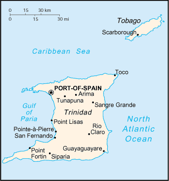 Map of Trinidad and Tobago | |
 Trinidad Location of Trinidad in the Lesser Antilles | |
| Geography | |
| Location | Windward Islands |
| Coordinates | 10°27′38″N 61°14′55″W / 10.46056°N 61.24861°WCoordinates: 10°27′38″N 61°14′55″W / 10.46056°N 61.24861°W |
| Area | 4,748 km2 (1,833 sq mi) |
| Highest elevation | 940 m (3,080 ft) |
| Highest point | El Cerro del Aripo |
| Administration | |
| Island | Trinidad |
| Capital city | Port of Spain |
| Largest settlement | Chaguanas (pop. 83,516) |
| Demographics | |
| Population | 1,267,145[1] (2011) |
| Pop. density | 266 /km2 (689 /sq mi) |
| Languages |
Trinidadian Standard English, Trinidadian Creole, Tobagonian Creole, Caribbean Hindustani |
| Currency | Trinidad and Tobago Dollar (TTD) |
| Religions | Christianity, Hinduism, Islam, Rastafarianism |
| Ethnic groups | Indian, African, Amerindian, European, Chinese, Arabs, Latino |
| Additional information | |
| Time zone | |


Trinidad is the larger and more populous of the two major islands of Trinidad and Tobago. The island lies 11 km (6.8 mi) off the northeastern coast of Venezuela and sits on the continental shelf of South America. Though geographically part of the South American continent, from a socio-economic standpoint it is often referred to as the southernmost island in the Caribbean. With an area of 4,768 km2 (1,841 sq mi), it is also the sixth largest in the West Indies.
Name
Many believe the original name for the island in the Arawaks' language was Iëre which meant "Land of the Hummingbird". Some believe that Iere was actually a mispronunciation or corruption by early colonists of the Arawak word kairi which simply means island. Christopher Columbus renamed it "La Isla de la Trinidad" ("The Island of the Trinity"), fulfilling a vow he had made before setting out on his third voyage.[2] This has since been shortened to Trinidad.
History
Caribs and Arawaks lived in Trinidad long before Christopher Columbus encountered the islands on his third voyage in 1498. Tobago changed hands between the British, French, Dutch and Courlanders, but eventually ended up in British hands. Trinidad remained Spanish until 1797, but it was largely settled by French colonists from the French Caribbean, especially Martinique.[3] In 1889 the two islands became a single British Crown colony. Trinidad and Tobago obtained self-governance in 1958 and independence from the United Kingdom in 1962.[4]
Geography
Major landforms include the hills of the Northern, Central and Southern Ranges (Dinah ranges), the Caroni, Nariva and Oropouche Swamps, and the Caroni and Naparima Plains. Major river systems include the Caroni, North and South Oropouche and Ortoire Rivers. There are many other natural landforms such as beaches and waterfalls. Trinidad has two seasons per calendar year: the rainy season and the dry season. El Cerro del Aripo, at 940 metres (3,084 ft), is the highest point in Trinidad. It is part of the Aripo Massif and is located in the Northern Range on the island, northeast of the town of Arima.
Culture
Diversity is the status quo in Trinidad. It is sometimes known as a "rainbow island" or more fondly "a callaloo" (local dialect for a delicious dish prepared by blending a variety of ingredients). There is a wide range of ethnicity, religion, and culture. As of the 2011 Trinidad and Tobago Census, the population was 35.43% East Indian, 34.22% African, 7.66% Mixed – African and East Indian, and 15.16% Mixed – Other.[1] Venezuela has also had a great impact on Trinidad's culture, such as introducing the music style parang to the island. Many groups overlap. For example, a "Dougla" is a person of African and East Indian descent who may identify as being part of either group.[5][6][7] Trinidad religion primarily centers round Roman Catholic, Anglican, other Christian denominations, Hindu and Muslim faiths. There are a minority of people who are followers of the Traditional African Religion, Yoruba/Trinidad Orisha, the Amerindian Religion, Jewish, Sikh, Jain, Taoist/Chinese folk religion/Confucianism, Buddhist, Bahá'í, and Zorastrian. Catholicism constitutes the largest religious denomination of the country. There are multiple festivals featuring the music of the Caribbean and the steelpan, which originated in Trinidad and is the country's national instrument. These festivals include the world-famous Carnival, J'ouvert, and Panorama, the national steel pan competition. Trinidad also has many public holidays, such as Indian Arrival Day, Emancipation Day, Independence Day, Republic Day, Labour Day, Boxing Day, New Year's Day, Divali, Phagwah, Eid al-Fitr, Corpus Christi, Good Friday, Easter, Easter Monday, Christmas, and Spiritual Baptist/Shouter Liberation Day. There are also places that can be visited that hold cultural significance, such as Mount Saint Benedict and the Temple in the Sea.
Education
The education system consists of government funded secondary schools where entry is determined by Secondary Entrance Assessment. S.E.A is the national exam all students write which determines the school they will be allowed into based on their grade in Mathematics, English Grammar, and Creative Writing. Students are allowed to create a list with schools they would like to attend. Secondary schools follow the British System where they write a standard Caribbean Examination from the Caribbean Examinations Council in Form 5. Some students may go on to write the Caribbean Advanced Proficiency Examination in Upper 6. They may then attend one of the island's universities: The University of The West Indies or The University of Trinidad and Tobago.
Zoology
Further information: Natural history of Trinidad and Tobago

The island of Trinidad has a rich biodiversity (see the link above for more detail). The fauna is overwhelmingly of South American origin. There are about 100 species of mammals including the Guyanan red howler monkey, the collared peccary, the red brocket deer, the ocelot and about 70 species of bats.[8] There are over 400 species of birds including the endemic Trinidad piping-guan. Reptiles are well represented, with about 92 recorded species including the largest species of snake in the world, the green anaconda, the spectacled caiman, and one of the largest lizards in the Americas, the green iguana. The largest of turtles (the leatherback turtle) nests on Trinidad's eastern and northern beaches. There are 37 recorded frogs, including the beautiful, little El Tucuche golden tree frog, and the more widespread, huge cane toad. About 43 species of freshwater fishes are known from Trinidad, including the well known guppy. It is estimated that there are at least 80,000 arthropods, inclusive of over 600 species of butterflies.
Economy
It is an industrial island with a diversified economy, based to a large extent on oil, natural gas, industry and agriculture. It is one of the leading gas-based export centres in the world, being the leading exporter of ammonia and methanol and among the top five exporters of liquefied natural gas. This has allowed Trinidad to capitalise on the biggest mineral reserves within its territories. It is an oil-rich country and stable economically.
Geology


The Venezuela Tertiary Basin is a subsidence basin formed between the Caribbean and South American plates, and is bounded on the north by the coast ranges of Venezuela and the Northern Range of Trinidad, and bounded on the south by the Guayana shield.[10] This Guayana shield supplied fine-grained clastic sediments, which with the subsidence, formed a regional negative gravity anomaly and growth faults.[11] Oil and gas discoveries from the Pliocene Moruga Group include Teak (1968), Samaan (1971), Poui (1972) and Galeota.[12] These fields are mainly faulted anticline traps producing from depths of 1.2 to 4.2 km (0.75 to 2.61 mi) subsea, with Teak possessing a hydrocarbon column almost 1 km (0.62 mi) thick.[11]
See also
-
 Trinidad and Tobago portal
References
- 1 2 Trinidad and Tobago 2011 Population and Housing Census Demographic Report (PDF) (Report). Trinidad and Tobago Central Statistical Office. p. 26. Retrieved 27 May 2016.
- ↑ Hart, Marie (1972) [1965]. The New Trinidad and Tobago: A Descriptive Account of the Geography and History of Trinidad and Tobago. London and Glasgow: Collins. p. 13.
- ↑ Besson, Gerard (2000-08-27). "Land of Beginnings – A historical digest", Newsday Newspaper.
- ↑ "Railroad Map of Trinidad". World Digital Library. 1925. Retrieved 2013-10-25.
- ↑ Brereton, Bridget (6 June 2002). "Race Relations in Colonial Trinidad 1870-1900". Cambridge University Press. Retrieved 2 August 2017 – via Google Books.
- ↑ "Trinidad French Creole". Une.edu.au. Retrieved 2 August 2017.
- ↑
- ↑ "Bats of Trinidad". TriniBats.com. Retrieved 2016-11-27.
- ↑ Woodside, P.R., The Petroleum Geology of Trinidad and Tobago, 1981, USGS Report 81-660, Washington: US Dept. of the Interior, p. 4a
- ↑ Bane, S.C., and Chanpong, R.R., 1980, Geology and Development of the Teak Oil Field, Trinidad, West Indies, in Giant Oil and Gas Fields of the Decade: 1968–1978, AAPG Memoir 30, Tulsa: American Association of Petroleum Geologists, ISBN 0891813063, p. 392
- 1 2 Bane, S.C., and Chanpong, R.R., 1980, Geology and Development of the Teak Oil Field, Trinidad, West Indies, in Giant Oil and Gas Fields of the Decade: 1968–1978, AAPG Memoir 30, Tulsa: American Association of Petroleum Geologists, ISBN 0891813063, p. 387
- ↑ Woodside, P.R., The Petroleum Geology of Trinidad and Tobago, 1981, USGS Report 81-660, Washington: US Dept. of the Interior, pp. 2 and 25
External links
| Look up trinidad in Wiktionary, the free dictionary. |
-
 Trinidad travel guide from Wikivoyage
 - Trinidad and Tobago Tourism Website
| Major Islands | ||
|---|---|---|
| Bocas Islands | ||
| The Five Islands | ||
| San Diego Islands | ||
| Islands off Tobago |
| |
| Other Islands | ||