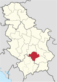
Toplica District
| Toplički okrug Топлички округ | |
|---|---|
| District of Serbia | |
 Location of the Toplica District within Serbia | |
| Country |
|
| Region | Southern and Eastern Serbia |
| Administrative center | Prokuplje |
| Government | |
| • Commissioner | Nebojša Vukadinović |
| Area | |
| • Total | 2,231 km2 (861 sq mi) |
| Population (2011 census) | |
| • Total | 91,754 |
| • Density | 41.1/km2 (106/sq mi) |
| ISO 3166 code | RS-21 |
| Municipalities | 4 |
| Settlements | 267 |
| - Cities and towns | 4 |
| - Villages | 263 |
The Toplica District (Serbian: Toplički okrug, Serbian Cyrillic: Топлички округ, pronounced [tǒplit͡ʃkiː ôkruːɡ]) is one of nine administrative districts of Southern and Eastern Serbia. It expands to the southern parts of Serbia. It has a population of 91,754 and has been named after the river Toplica. The administrative center is the city of Prokuplje.
Municipalities
It encompasses the municipalities of:
Demographics
| Historical population | ||
|---|---|---|
| Year | Pop. | ±% |
| 1948 | 141,502 | — |
| 1953 | 149,421 | +5.6% |
| 1961 | 141,141 | −5.5% |
| 1971 | 129,542 | −8.2% |
| 1981 | 121,933 | −5.9% |
| 1991 | 111,813 | −8.3% |
| 2002 | 102,075 | −8.7% |
| 2011 | 91,754 | −10.1% |
| Source: [1] | ||
According to the last official census done in 2011, Toplica District has 91,754 inhabitants. Most of its population is of Serbian nationality (93.46%) while 50.02% of the municipality’s population is urban.
Ethnic composition of the municipality:
| Ethnic group | Population |
|---|---|
| Serbs | 85,750 |
| Romani | 3,945 |
| Montenegrins | 176 |
| Macedonians | 97 |
| Romanians | 76 |
| Croats | 50 |
| Others | 1,660 |
| Total | 91,754 |
Economy
The Toplički District is a medium developed industrial center, in which the most prominent are the "Prokupac" - alcoholic beverage factory, the "Hissar" food factory, the "FOM" ferrous metal plant and the "Topličanka" cotton mill.
See also
Notes
- ↑ Kosovo is the subject of a territorial dispute between the Republic of Kosovo and the Republic of Serbia. The Republic of Kosovo unilaterally declared independence on 17 February 2008, but Serbia continues to claim it as part of its own sovereign territory. The two governments began to normalise relations in 2013, as part of the Brussels Agreement. Kosovo has received formal recognition as an independent state from 111 out of 193 United Nations member states.
- ↑ "2011 Census of Population, Households and Dwellings in the Republic of Serbia" (PDF). stat.gov.rs. Statistical Office of the Republic of Serbia. Retrieved 12 January 2017.
Note: All official material made by Government of Serbia is public by law. Information was taken from official website.
External links
| Wikimedia Commons has media related to Toplica District. |
- Топлички управни округ (Serbian)
Coordinates: 43°14′N 21°36′E / 43.233°N 21.600°E
