Shire of Tingalpa
| Shire of Tingalpa Queensland | |
|---|---|
| Population | 1,776 (1923 est.)[1] |
| • Density | 5.73/km2 (14.84/sq mi) |
| Established | 1879 |
| Area | 310 km2 (119.7 sq mi) |
| Council seat | Mount Cotton |
| Region | Brisbane |
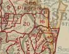
The Shire of Tingalpa was a local government area in the south-eastern suburbs of Brisbane, Queensland, Australia. The shire, administered from Mount Cotton, covered an area of 120 square miles (311 km2), and existed as a local government entity from 1879 until 1949.
History

On 11 November 1879, the Tingalpa Division was created as one of 74 divisions within Queensland under the Divisional Boards Act 1879 with a population of 1,490.[2]
However, the residents of Cleveland sought to be independent of the division[3] and on 29 May 1885, Cleveland Division was separated from Tingalpa Division.[4][5][6][7]
With the passage of the Local Authorities Act 1902, the Tingalpa Division became the Shire of Tingalpa on 31 March 1903.[8]
On 1 October 1925, the shire lost areas west of the Tingalpa Creek to the new City of Brisbane.
Amalgamations in 1948
On 9 December 1948, as part of a major reorganisation of local government in South East Queensland, an Order in Council replacing ten former local government areas between the City of Brisbane and the New South Wales border with only four.[9][10] The former ten were:
The four resulting local government areas were:
- the new Redland Shire, an amalgamation of Cleveland and the northern part of Tingalpa (which later became Redland City)
- the new Shire of Albert, a merger of Beenleigh, Coomera, Nerang (except for the Burleigh Heads area), the southern part of Tingalpa and the eastern part of Waterford[11]
- an enlarged Shire of Beaudesert, an amalgamation of Beaudesert and Tamborine with the western part of Waterford
- Town of South Coast, an amalgamation of the Towns of Southport and Coolangatta with the Burleigh Heads part of Nerang (which later became City of Gold Coast)
The Order came into effect on 10 June 1949, when the first elections were held.
Localities
- Mount Cotton[12]
- Carbrook[12]
- Daisy Hill[12]
- Kingston[12]
- Loganholme[12]
- Loganlea[12]
- Redland Bay
- Rochedale
- Slacks Creek[12]
- Victoria Point
- Woodridge[12]
Chairmen
- 1880: Mr Greaves[13]
- 1890: Hans Heinrich Heinemann[14]
- 1927: August Stern[15]
- Henry Heinemann (son of Hans Heinrich Heinemann)[16]
References
- ↑ Australian Bureau of Statistics (1924). Statistics of Queensland, 1923. p. 9F. Accessed at University of Melbourne, [[Parkville, Victoria|]].
- ↑ "Proclamation [Tingalpa Division]". Queensland Government Gazette. 11 November 1879. p. 25:989.
- ↑ "TINGALPA DIVISION.". The Brisbane Courier. National Library of Australia. 9 March 1885. p. 3. Retrieved 2 September 2013.
- ↑ "Proclamation [Cleveland Division constituted]". Queensland Government Gazette. 30 May 1885. p. 36:1734.
- ↑ "Proclamation [Tingalpa Division amended]". Queensland Government Gazette. 30 May 1885. p. 36:1733-1734.
- ↑ "Current News.". The Queenslander. Brisbane: National Library of Australia. 6 June 1885. p. 893. Retrieved 2 September 2013.
- ↑ "Agency ID10402, Cleveland Divisional Board". Queensland State Archives. Retrieved 2 September 2013.
- ↑ "Agency ID2490, Tingalpa Shire Council". Queensland State Archives. Retrieved 2 September 2013.
- ↑ "New coast names.". The Courier-Mail. Brisbane: National Library of Australia. 10 December 1948. p. 3. Retrieved 5 September 2013.
- ↑ "DETAILS OF SOUTH COAST SHIRES.". Queensland Times. Ipswich, Queensland: National Library of Australia. 10 December 1948. p. 1 Edition: DAILY. Retrieved 5 September 2013.
- ↑ "Agency ID290, Albert Shire Council". Queensland State Archives. Retrieved 4 September 2013.
- 1 2 3 4 5 6 7 8 Mary Howells. "Mount Cotton – a brief history" (PDF). Redland City Council. Retrieved 26 June 2014.
- ↑ "General News.". The Queenslander. Brisbane: National Library of Australia. 13 March 1880. p. 326. Retrieved 11 May 2014.
- ↑ Consolidated Index to Queensland Government Gazette 1859–1919. Queensland Family History Society. 2004. ISBN 1 876613 79 3.
- ↑ Pugh, Theophilus Parsons (1927). Pugh's Almanac for 1927. Retrieved 13 June 2014.
- ↑ Fox, Matthew Joseph (1923). History of Queensland: its People and its industries (PDF). Brisbane: States Publishing Company. Retrieved 5 April 2014.
Coordinates: 27°38′20.56″S 153°14′47″E / 27.6390444°S 153.24639°E