Timeline of the 2012 Atlantic hurricane season

The 2012 Atlantic hurricane season featured the third-most named storms for the third consecutive year on record.[1] Though the season officially began on June 1 and ended on November 30, dates which conventionally delimit the period of each year when most tropical cyclones develop in the Atlantic basin,[2] two storms – Alberto and Beryl – developed before the official start, on May 19 and May 26, respectively; this was the first such occurrence since the 1908 season.[3] The season's final storm to form, Tony, dissipated on October 25, although the previous cyclone, Sandy, did not do so until four days later.[4][5]
The season produced nineteen tropical cyclones, all of which intensified into tropical storms; ten became hurricanes, but only two strengthened into major hurricanes.[nb 1][nb 2] Storm impact during the season was widespread and ruinous, with the most significant storms in term of loss of life and damage being hurricanes Isaac and Sandy. A Category 1 on the Saffir–Simpson hurricane wind scale, Isaac was a large system that moved ashore the coast of Louisiana on August 12; the storm resulted in 41 deaths overall.[8] Sandy, the second and final major hurricane of the season, was the largest Atlantic hurricane ever recorded, with a wind diameter of more than 1,100 mi (1,800 km). The system moved ashore the southern coast of New Jersey as an extratropical cyclone in late October. During its duration as a tropical cyclone, Sandy caused at least $68 billion (2012 USD) in damage and 285 fatalities.[9][10] Sandy is the second-costliest Atlantic hurricane in recorded history, surpassed only by Hurricane Katrina during the 2005 season.[11]
This timeline includes information that was not operationally released, meaning that data from post-storm reviews by the National Hurricane Center, such as a storm that was not operationally warned upon, has been included. This timeline documents tropical cyclone formations, strengthening, weakening, landfalls, extratropical transitions, and dissipations during the season.
Timeline of events

May
- May 19
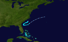
- 0600 UTC (2:00 a.m. EDT) – A tropical depression develops from an area of low pressure offshore the North Carolina–South Carolina border.[12]
- 1200 UTC (8:00 a.m. EDT) – The tropical depression intensifies into Tropical Storm Alberto.[12]
- May 20
- 0000 UTC (8:00 p.m. EDT May 19) – Tropical Storm Alberto attains its peak intensity with winds of 60 mph (95 km/h) and a minimum barometric pressure of 995 mbar (hPa; 29.38 inHg).[12]
- May 22
- 1200 UTC (8:00 a.m. EDT) – Tropical Storm Alberto degenerates into a non-convective remnant area of low pressure a few hundred miles north of Bermuda.[12][12]
- May 26
- 0000 UTC (8:00 p.m. EDT May 25) – Subtropical Storm Beryl develops from an area of low pressure roughly 335 mi (540 km)[nb 3] east of Jacksonville, Florida.[14]
- May 27

- 1800 UTC (2:00 p.m. EDT) – Subtropical Storm Beryl transitions into a tropical storm.[14]
- 2300 UTC (7:00 p.m. EDT) – Tropical Storm Beryl attains its peak intensity with winds of 70 mph (110 km/h) and a minimum barometric pressure of 992 mbar (hPa; 29.29 inHg).[14]
- May 28
- 0410 UTC (12:10 a.m. EDT) – Tropical Storm Beryl makes landfall near Jacksonville Beach, Florida, with winds of 65 mph (100 km/h).[14]
- 1200 UTC (8:00 a.m. EDT) – Tropical Storm Beryl weakens to a tropical depression.[14]
- May 30
- 0600 UTC (2:00 a.m. EDT) – Tropical Depression Beryl regains tropical storm intensity roughly 190 mi (305 km) southwest of Wilmington, North Carolina.[14]
- 1800 UTC (2:00 p.m. EDT) – Tropical Depression Beryl degenerates into a non-convective remnant area of low pressure near the coast of North Carolina.[14]
June
- June 1
- The 2012 Atlantic hurricane season officially begins.[2]
- June 18
- 1800 UTC (2:00 p.m. AST) – A subtropical storm develops from an area of low pressure roughly 450 mi (720 km) north-northeast of Bermuda.[15]
- June 19
- 1200 UTC (8:00 a.m. AST) – The subtropical storm transitions into Tropical Storm Chris.[15]
- June 21
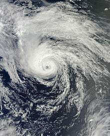
- 0600 UTC (2:00 a.m. AST) – Tropical Storm Chris intensifies into a Category 1 hurricane on the Saffir–Simpson hurricane wind scale, becoming the first of the 2012 season.[15]
- 1200 UTC (8:00 a.m. AST) – Hurricane Chris attains its peak intensity with winds of 85 mph (140 km/h) and a minimum barometric pressure of 974 mbar (hPa; 28.76 inHg) roughly 635 mi (1,020 km) southeast of Cape Race.[15]
- June 22
- 0000 UTC (8:00 p.m. AST June 21) – Hurricane Chris weakens to a tropical storm.[15]
- 1200 UTC (8:00 a.m. AST) – Tropical Storm Chris transitions into an extratropical cyclone roughly 385 mi (620 km) east-southeast of Cape Race.[15]
- June 23
- 1200 UTC (8:00 a.m. EDT) – Tropical Storm Debby develops from an area of low pressure roughly 290 mi (470 km) south-southeast of the mouth of the Mississippi River.[16]
- June 24
- 1800 UTC (2:00 p.m. EDT) – Tropical Storm Debby attains maximum sustained winds of 65 mph (100 km/h).[16]
- June 25
- 0000 UTC (8:00 p.m. EDT June 24) – Tropical Storm Debby attains its peak intensity with a minimum barometric pressure of 990 mbar (hPa; 29.23 inHg).[16]
- June 26
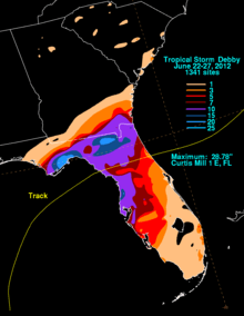
- 2100 UTC (5:00 p.m. EDT) – Tropical Storm Debby makes landfall near Steinhatchee, Florida, with winds of 40 mph (65 km/h).[16]
- June 27
- 0000 UTC (8:00 p.m. EDT June 26) – Tropical Storm Debby weakens to a tropical depression roughly 35 mi (55 km) southwest of Gainesville, Florida.[16]
- 1800 UTC (2:00 p.m. EDT) – Tropical Storm Debby dissipates offshore the eastern coast of Florida.[16]
July
- No tropical cyclones form in the Atlantic Ocean during the month of July.
August
- August 1
- 1200 UTC (8:00 a.m. AST) – Tropical Depression Five develops from an area of low pressure roughly 875 mi (1,410 km) east of the Windward Islands.[17]
- August 2
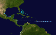
- 1200 UTC (8:00 a.m. AST) – Tropical Depression Five intensifies into Tropical Storm Ernesto.[17]
- August 3
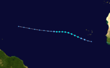
- 1200–1800 UTC (8:00 a.m. – 2:00 p.m. AST) – Tropical Storm Ernesto crosses the Windward Islands into the eastern Caribbean Sea.[17]
- 1800 UTC (2:00 p.m. AST) – Tropical Depression Six develops from an area of low pressure roughly 150 mi (240 km) south-southwest of the southernmost Cape Verde Islands.[18]
- August 4
- 0600 UTC (2:00 a.m. AST) – Tropical Depression Six intensifies into Tropical Storm Florence roughly 290 mi (470 km) west of the southernmost Cape Verde Islands.[18]
- August 5
- 0000 UTC (8:00 p.m. AST August 4) – Tropical Storm Florence attains its peak intensity with winds of 60 mph (95 km/h) and a minimum barometric pressure of 1002 mbar (hPa; 29.59 inHg).[18]
- August 6
- 0600 UTC (2:00 a.m. AST) – Tropical Storm Florence weakens to a tropical depression.[18]
- 1200 UTC (8:00 a.m. AST) – Tropical Depression Florence degenerates into a non-convective remnant area of low pressure roughly midway between the Cape Verde Islands and the Lesser Antilles.[18]
- August 7
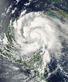
- 1200 UTC (8:00 a.m. EDT) – Tropical Storm Ernesto intensifies into a Category 1 hurricane roughly 260 mi (420 km) east of Chetumal, Mexico.[17]
- August 8
- 0100 UTC (8:00 p.m. CDT August 7) – Hurricane Ernesto makes its first landfall on Cayo Norte in Banco Chinchorro, Mexico, with winds of 90 mph (150 km/h).[17]
- 0315 UTC (10:15 p.m. CDT August 7) – Hurricane Ernesto intensifies into a Category 2 hurricane, attains its peak intensity with winds of 100 mph (160 km/h) and a minimum barometric pressure of 973 mbar (hPa; 28.73 inHg), and simultaneously makes its second landfall near Majaual, Mexico.[17]
- 1200 UTC (7:00 a.m. CDT) – Hurricane Ernesto weakens to a tropical storm.[17]
- 1800–0000 UTC (1:00–7:00 p.m. CDT) – Tropical Storm Ernesto emerges into the Bay of Campeche.[17]
- August 9
- 1615 UTC (11:15 a.m. CDT) – Tropical Storm Ernesto makes its third and final landfall roughly 10 mi (15 km) northwest of Coatzacoalcos, Mexico, with winds of 65 mph (100 km/h).[17]
- 1800 UTC (2:00 p.m. AST) – Tropical Depression Seven develops from an area of low pressure roughly midway between the Cape Verde Islands and the Lesser Antilles.[19]
- August 10
- 0600 UTC (1:00 a.m. CDT) – Tropical Storm Ernesto weakens to a tropical depression.[17]
- 1200 UTC (7:00 a.m. CDT) – Tropical Depression Ernesto dissipates over the mountainous terrain of Mexico.[17]
- August 11
- 1200 UTC (8:00 a.m. AST) – Tropical Depression Seven degenerates into a tropical wave east of the Lesser Antilles.[19]
- August 15
- 1200 UTC (8:00 a.m. AST) – Tropical Depression Eight develops from an area of low pressure roughly 690 mi (1,110 km) southeast of Bermuda.[20]
- August 16
- 0000 UTC (8:00 p.m. AST August 15) – Tropical Depression Eight intensifies into Tropical Storm Gordon.[20]
- August 17
- 1200 UTC (7:00 a.m. CDT) – The remnants of Tropical Depression Seven regenerate into a tropical depression roughly 230 mi (370 km) southeast of Tampico, Mexico.[19]
- 1800 UTC (1:00 p.m. CDT) – Tropical Depression Seven intensifies into Tropical Storm Helene and simultaneously attains its peak intensity with winds of 45 mph (75 km/h) and a minimum barometric pressure of 1004 mbar (hPa; 29.65 inHg).[19]
.jpg)
- August 18
- 0600 UTC (1:00 a.m. CDT) – Tropical Storm Helene weakens to a tropical depression.[19]
- 0600 UTC (2:00 a.m. AST) – Tropical Storm Gordon intensifies into a Category 1 hurricane roughly 575 mi (925 km) west-southwest of the Azores.[20]
- 1200 UTC (7:00 a.m. CDT) – Tropical Depression Helene makes landfall near Tampico, Mexico, with winds of 35 mph (55 km/h).[19]
- August 19
- 0000 UTC (7:00 p.m. CDT August 18) – Tropical Depression Helene degenerates into a non-convective remnant area of low pressure over the mountainous terrain of Mexico.[19]
- 0000 UTC (8:00 p.m. AST August 18) – Hurricane Gordon attains its peak intensity with winds of 110 mph (175 km/h) and a minimum barometric pressure of 965 mbar (hPa; 28.49 inHg).[20]
- August 20
- 0530 UTC (1:30 a.m. AST) – Hurricane Gordon makes landfall on Santa Maria Island, Azores, with winds of 75 mph (120 km/h).[20]
- 1200 UTC (8:00 a.m. AST) – Hurricane Gordon weakens to a tropical storm.[20]
- 1800 UTC (2:00 p.m. AST) – Tropical Storm Gordon degenerates into a non-convective remnant area of low pressure northeast of the Azores.[20]
- August 21
- 0600 UTC (2:00 a.m. AST) – Tropical Depression Nine develops from an area of low pressure roughly 720 mi (1,160 km) east of the Lesser Antilles.[21]
- 1800 UTC (2:00 p.m. AST) – Tropical Depression Nine intensifies into Tropical Storm Isaac roughly 520 mi (840 km) east of the Lesser Antilles.[21]
- August 22
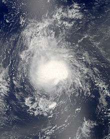
- 0600 UTC (2:00 a.m. AST) – Tropical Depression Ten develops from an area of low pressure roughly 690 mi (1,110 km) west-southwest of the Cape Verde Islands.[22]
- 1800–0000 UTC August 23 (2:00–8:00 p.m. AST) – Tropical Storm Isaac crosses the Windward Islands into the eastern Caribbean Sea.[21]
- August 23
- 1200 UTC (8:00 a.m. AST) – Tropical Depression Ten intensifies into Tropical Storm Joyce roughly 1,210 mi (1,950 km) west of the Cape Verde Islands.[22]
- 1800 UTC (2:00 p.m. AST) – Tropical Storm Joyce attains its peak intensity with winds of 40 mph (65 km/h) and a minimum barometric pressure of 1006 mbar (hPa; 29.71 inHg).[22]
- August 24
- 0000 UTC (8:00 p.m. AST August 23) – Tropical Storm Joyce weakens to a tropical depression.[22]
- 1200 UTC (8:00 a.m. AST) – Tropical Depression Joyce degenerates into a non-convective remnant area of low pressure.[22]
- August 25
- 0600 UTC (2:00 a.m. AST) – Tropical Storm Isaac makes its first landfall near Jacmel, Haiti, with winds of 65 mph (100 km/h).[21]
- 1500 UTC (11:00 a.m. EDT) – Tropical Storm Isaac makes its second landfall near Cajobabo, Guantánamo, Cuba, with winds of 60 mph (95 km/h).[21]
- August 27

- 0000–0600 UTC (8:00 p.m. August 26–2:00 a.m. AST) – Tropical Storm Isaac crosses the Straits of Florida into the Gulf of Mexico.[21]
- August 28
- 1200 UTC (7:00 a.m. CDT) – Tropical Storm Isaac intensifies into a Category 1 hurricane roughly 90 mi (145 km) southeast of the mouth of the Mississippi River.[21]
- 1800 UTC (2:00 p.m. AST) – Tropical Depression Eleven develops from an area of low pressure roughly 1,290 mi (2,080 km) southwest of the western Azores.[23]
- August 29
- 0000 UTC (7:00 p.m. CDT August 28) – Hurricane Isaac makes its third landfall at Southwest Pass at the mouth of the Mississippi River, with winds of 80 mph (130 km/h).[21]
- 0000 UTC (8:00 p.m. AST August 28) – Tropical Depression Eleven intensifies into Tropical Storm Kirk.[23]
- 0300 UTC (10:00 a.m. CDT) – Hurricane Isaac attains its peak intensity with winds of 80 mph (130 km/h) and a minimum barometric pressure of 965 mbar (hPa; 28.5 inHg).[21]
- 0800 UTC (3:00 a.m. CDT) – Hurricane Isaac makes its fourth and final landfall near Port Fourchon, Louisiana, with winds of 80 mph (130 km/h).[21]
- 1800 UTC (1:00 p.m. CDT) – Hurricane Isaac weakens to a tropical storm roughly 40 mi (65 km) west-southwest of New Orleans, Louisiana.[21]
- August 30
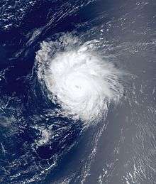
- 0000 UTC (8:00 p.m. AST August 29) – Tropical Depression Twelve develops from an area of low pressure roughly 1,495 mi (2,405 km) east-southeast of the northern Leeward Islands.[24]
- 1200 UTC (8:00 a.m. AST) – Tropical Storm Kirk intensifies into a Category 1 hurricane.[23]
- 1200 UTC (8:00 a.m. EDT) – Tropical Depression Twelve intensifies into Tropical Storm Leslie.[24]
- August 31
- 0000 UTC (7:00 p.m. CDT August 30) – Tropical Storm Isaac weakens to a tropical depression over southern Arkansas.[21]
- 0600 UTC (2:00 a.m. AST) – Hurricane Kirk intensifies into a Category 2 hurricane and simultaneously attains its peak intensity with winds of 105 mph (165 km/h) and a minimum barometric pressure of 970 mbar (hPa; 28.64 inHg).[23]
- 1800 UTC (2:00 p.m. AST) – Hurricane Kirk weakens to a Category 1 hurricane.[23]
September
- September 1
- 1200 UTC (7:00 a.m. CDT) – Tropical Depression Isaac dissipates roughly 65 mi (105 km) west-southwest of Jefferson City, Missouri.[21]
- 1200 UTC (8:00 a.m. AST) – Hurricane Kirk weakens to a tropical storm.[23]
- September 3
- 0000 UTC (8:00 p.m. AST September 2) – Tropical Storm Kirk transitions into an extratropical cyclone roughly 1,035 mi (1,665 km) north of the Azores.[23]
- 0600 UTC (2:00 a.m. AST) – Tropical Depression Thirteen develops from an area of low pressure.[25]
- September 4
- 0600 UTC (2:00 a.m. AST) – Tropical Depression Thirteen intensifies into Tropical Storm Michael roughly 1,240 mi (1,995 km) southwest of the Azores.[25]
- September 5
- 0600 UTC (2:00 a.m. AST) – Tropical Storm Leslie intensifies into a Category 1 hurricane.[24]
- 1200 UTC (8:00 a.m. AST) – Hurricane Leslie attains maxiumum sustained winds of 80 mph (130 km/h) roughly 485 mi (780 km) south-southeast of Bermuda.[24]
- 1800 UTC (2:00 p.m. AST) – Tropical Storm Michael intensifies into a Category 1 hurricane.[25]
- September 6
.jpg)
- 0600 UTC (2:00 a.m. AST) – Hurricane Michael intensifies into a Category 2 hurricane.[25]
- 1200 UTC (8:00 a.m. AST) – Hurricane Michael intensifies into a Category 3 hurricane, the first major hurricane of the season, and simultaneously attains its peak intensity with winds of 115 mph (185 km/h) and a minimum barometric pressure of 964 mbar (hPa; 28.47 inHg).[25]
- 1800 UTC (2:00 p.m. AST) – Hurricane Michael weakens to a Category 2 hurricane.[25]
- September 7
- 1200 UTC (8:00 a.m. AST) – Hurricane Leslie weakens to a tropical storm.[24]
- September 8
- 0000 UTC (8:00 p.m. AST September 7) – Hurricane Michael weakens to a Category 1 hurricane.[25]
- 1200 UTC (8:00 a.m. AST) – Hurricane Michael re-intensifies into a Category 2 hurricane.[25]
- September 9
- 1800 UTC (2:00 p.m. AST) – Hurricane Michael weakens to a Category 1 for a second time.[25]
- September 10
- 1200 UTC (8:00 a.m. AST) – Tropical Storm Leslie re-intensifies into a Category 1 hurricane.[24]
- 1200 UTC (8:00 a.m. AST) – Tropical Depression Fourteen develops from an area of low pressure roughly 890 mi (1,430 km) west of the Cape Verde Islands.[26]
- September 11
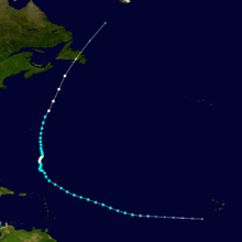
- 0000 UTC (8:00 p.m. AST September 10) – Hurricane Michael weakens to a tropical storm.[25]
- 0600 UTC (2:00 a.m. AST) – Hurricane Leslie attains its peak intensity with a minimum barometric pressure of 968 mbar (hPa; 28.58 inHg).[24]
- 0900 UTC (5:00 a.m. AST) – Hurricane Leslie transitions into an extratropical cyclone roughly 90 mi (145 km) southwest of St. Lawrence, Newfoundland.[24]
- 1800 UTC (2:00 p.m. AST) – Tropical Storm Michael degenerates into a non-convective remnant area of low pressure roughly 1150 mi (1850 km) northeast of Bermuda.[25]
- September 12
- 0000 UTC (8:00 p.m. AST September 11) – Tropical Depression Fourteen intensifies into Tropical Storm Nadine.[26]
- September 14
- 1800 UTC (2:00 p.m. AST) – Tropical Storm Nadine intensifies into a Category 1 hurricane.[26]
- September 17
- 0000 UTC (8:00 p.m. AST September 16) – Hurricane Nadine weakens to a tropical storm.[26]
- September 21
- 1800 UTC (2:00 p.m. AST) – Tropical Storm Nadine degenerates into a non-tropical area of low pressure roughly 260 mi (420 km) south-southwest of Santa Maria Island.[26]
- September 23
- 0000 UTC (8:00 p.m. AST September 22) – The remnants of Tropical Storm Nadine regenerate into a tropical storm south of the Azores.[26]
- September 28
- 1200 UTC (8:00 a.m. AST) – Tropical Storm Nadine intensifies into a Category 1 hurricane for a second time.[26]
- September 30

- 1200 UTC (8:00 a.m. AST) – Hurricane Nadine attains its peak intensity with winds of 90 mph (150 km/h) and a minimum barometric pressure of 978 mbar (hPa; 28.88 inHg) roughly 420 mi (675 km) west-southwest of Flores Island, Azores.[26]
October
- October 1
- 1200 UTC (8:00 a.m. AST) – Hurricane Nadine weakens to a tropical storm.[26]
- October 3
- 0600 UTC (2:00 a.m. AST) – Tropical Depression Fifteen develops from an area of low pressure roughly 1,035 mi (1,665 km) west of the Cape Verde Islands.[27]
- 1800 UTC (2:00 p.m. AST) – Tropical Depression Fifteen intensifies into Tropical Storm Oscar.[27]
- October 4
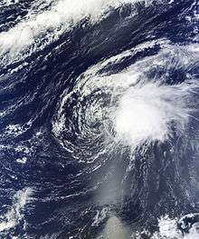
- 0000 UTC (8:00 p.m. AST October 3) – Tropical Storm Nadine degenerates into a non-convective remnant area of low pressure roughly 195 mi (315 km) southwest of the central Azores.[26]
- October 5
- 0600 UTC (2:00 a.m. AST) – Tropical Storm Oscar attains its peak intensity with winds of 50 mph (85 km/h) and a minimum barometric pressure of 994 mbar (hPa; 29.35 inHg).[27]
- 1800 UTC (2:00 p.m. AST) – Tropical Storm Oscar dissipates over the central Atlantic Ocean.[27]
- October 11
- 0000 UTC (8:00 p.m. EDT October 10) – Tropical Depression Sixteen develops from an area of low pressure.[28]
- 0600 UTC (2:00 a.m. EDT) – Tropical Depression Sixteen intensifies into Tropical Storm Patty roughly 175 mi (280 km) east-northeast of San Salvador, Bahamas.[28]
- October 12
- 0000 UTC (8:00 p.m. EDT October 11) – Tropical Storm Patty attains its peak intensity with winds of 45 mph (75 km/h) and a minimum barometric pressure of 1005 mbar (hPa; 29.68 inHg).[28]
- 1800 UTC (2:00 p.m. AST) – Tropical Storm Rafael develops from an area of low pressure roughly 230 mi (370 km) south-southeast of St. Croix, U.S. Virgin Islands.[29]
- October 13
- 0600 UTC (2:00 a.m. EDT) – Tropical Storm Patty weakens to a tropical depression.[28]
- 1200 UTC (8:00 a.m. EDT) – Tropical Depression Patty dissipates northeast of the Bahamas.[28]
- October 14
- 0000–0600 UTC (8:00 p.m. October 13–2:00 a.m. AST) – Tropical Storm Rafael crosses the Leeward Islands into the western Atlantic Ocean.[29]
- October 15
- 0600 UTC (2:00 a.m. AST) – Tropical Storm Rafael intensifies into a Category 1 hurricane roughly 750 mi (1,210 km) south of Bermuda.[29]
- October 16
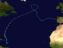
- 1200 UTC (8:00 a.m. AST) – Hurricane Rafael attains its peak intensity with winds of 90 mph (150 km/h) and a minimum barometric pressure of 969 mbar (hPa; 28.61 inHg) roughly 345 mi (555 km) south of Bermuda.[29]
- October 17
- 1800 UTC (2:00 p.m. AST) – Hurricane Rafael transitions into an extratropical cyclone several hundred miles southeast of Nova Scotia.[29]
- October 22
- 1200 UTC (8:00 a.m. EDT) – Tropical Depression Eighteen develops from an area of low pressure roughly 350 mi (560 km) south-southwest of Kingston, Jamaica.[5]
- 1800 UTC (2:00 p.m. EDT) – Tropical Depression Eighteen intensifies into Tropical Storm Sandy.[5]
- 1800 UTC (2:00 p.m. AST) – Tropical Depression Nineteen develops from an area of low pressure roughly 715 mi (1,150 km) east-northeast of the northern Leeward Islands.[4]
- October 24
- 0000 UTC (8:00 p.m. AST October 23) – Tropical Depression Nineteen intensifies into Tropical Storm Tony.[4]
- 1200 UTC (8:00 a.m. EDT) – Tropical Storm Sandy intensifies into a Category 1 hurricane roughly 90 mi (140 km) south of Kingston, Jamaica.[5]
- 1200 UTC (8:00 a.m. AST) – Tropical Storm Tony attains its peak intensity with winds of 50 mph (85 km/h) and a minimum barometric pressure of 1000 mbar (hPa; 29.53 inHg) roughly midway between the northern Leeward Islands and the Azores.[4]
- 1900 UTC (3:00 p.m. EDT) – Hurricane Sandy makes its first landfall near Bull Bay, Jamaica, with winds of 85 mph (140 km/h).[5]
- October 25
- 0000 UTC (8:00 p.m. EDT October 24) – Hurricane Sandy intensifies into a Category 2 hurricane.[5]
- 0525 UTC (1:25 a.m. EDT) – Hurricane Sandy intensifies into a Category 3 hurricane and simultaneously makes its second landfall roughly 10 mi (15 km) west of Santiago de Cuba, Cuba, with winds of 115 mph (185 km/h).[5]
- 0900–1200 UTC (5:00–8:00 a.m. EDT) – Hurricane Sandy crosses Cuba into the Bahamas.[5]
- 1800 UTC (2:00 p.m. AST) – Tropical Storm Tony transitions into an extratropical cyclone.[4]
- 0900 UTC (5:00 a.m. EDT) – Hurricane Sandy weakens to a Category 2 hurricane.[5]
- October 26
- 0000 UTC (8:00 p.m. EDT October 25) – Hurricane Sandy weakens to a Category 1 hurricane.[5]
- October 27
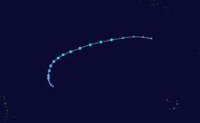
- 0000 UTC (8:00 p.m. EDT October 26) – Hurricane Sandy weakens to a tropical storm.[5]
- 1200 UTC (8:00 a.m. EDT) – Tropical Storm Sandy re-intensifies into a Category 1 hurricane roughly 145 mi (235 km) north-northeast of the Abaco Islands.[5]
- October 29
- 1200 UTC (8:00 a.m. EDT) – Hurricane Sandy re-intensifies into a Category 2 hurricane roughly 255 mi (410 km) southeast of Atlantic City, New Jersey.[5]
- 1800 UTC (2:00 p.m. EDT) – Hurricane Sandy weakens to a Category 1 hurricane for a second time and simultaneously attains its peak intensity with a minimum barometric pressure of 940 mbar (hPa; 27.76 inHg).[5]
- 2100 UTC (5:00 p.m. EDT) – Hurricane Sandy transitions into an extratropical cyclone roughly 50 mi (80 km) southeast of Atlantic City, New Jersey.[5]
- 2330 UTC (7:30 p.m. EDT) – The extratropical remnants of Hurricane Sandy make landfall near Brigantine, New Jersey, with winds of 80 mph (130 km/h).[5]
November
- No tropical cyclones formed in the Atlantic Ocean during the month of November.
- November 30
- The 2012 Atlantic hurricane season officially ends.[2]
See also
Notes
- ↑ An average season, as defined by the National Oceanic and Atmospheric Administration, has twelve tropical storms, six hurricanes and two major hurricanes.[6]
- ↑ A major hurricane is a storm that ranks as Category 3 or higher on the Saffir-Simpson hurricane wind scale.[7]
- ↑ The figures for maximum sustained winds and position estimates are rounded to the nearest 5 units (knots, miles, or kilometers), following the convention used in the National Hurricane Center's operational products for each storm.[13] All other units are rounded to the nearest digit.
References
- ↑ Brian McNoldy (November 28, 2012). "Third most active hurricane season on record (tie) ends Friday". The Washington Post. Retrieved May 4, 2013.
- 1 2 3 Chris Landsea; Neal Dorst (ed.) (June 2, 2011). "G: Tropical Cyclone Climatology". Hurricane Research Division: Frequently Asked Questions. Atlantic Oceanographic and Meteorological Laboratory. G1) When is hurricane season ?. Archived from the original on June 15, 2006. Retrieved May 4, 2013.
- ↑ Robbie J. Berg (June 1, 2012). "Tropical Weather Outlook". National Hurricane Center. Retrieved May 3, 2013.
- 1 2 3 4 5 Richard J. Pasch; David P. Roberts (January 24, 2013). Tropical Cyclone Report: Tropical Storm Tony (PDF) (Report). National Hurricane Center. pp. 1–2, 4. Retrieved May 3, 2013.
- 1 2 3 4 5 6 7 8 9 10 11 12 13 14 15 16 Eric S. Blake; et al. (February 12, 2013). Tropical Cyclone Report: Hurricane Sandy (PDF) (Report). National Hurricane Center. pp. 1–4, 24–25. Retrieved May 3, 2013.
- ↑ Climate Prediction Center Internet Team (August 4, 2011). "Background Information: The North Atlantic Hurricane Season". Climate Prediction Center. Retrieved May 4, 2013.
- ↑ Chris Landsea; Neal Dorst (ed.) (June 2, 2011). "A: Basic Definitions". Hurricane Research Division: Frequently Asked Questions. Atlantic Oceanographic and Meteorological Laboratory. A3) What is a super-typhoon? What is a major hurricane ? What is an intense hurricane ?. Archived from the original on June 15, 2006. Retrieved May 4, 2013.
- ↑ Michael S. Lee (December 4, 2012). "Active 2012 hurricane season had local impact". The Commercial. Retrieved July 9, 2013.
- ↑ "Billion-Dollar Weather/Climate Disasters". National Oceanic and Atmospheric Administration. Archived from the original on 2014-07-09. Retrieved June 13, 2013.
- ↑ Tom McCarthy (April 12, 2013). "'Sandy' to be retired as hurricane name by World Meteorological Organization". The Guardian. Retrieved July 9, 2013.
- ↑ "Report: Sandy was USA's 2nd-costliest hurricane". USA Today. February 12, 2013. Retrieved July 10, 2013.
- 1 2 3 4 5 Richard J. Pasch (December 7, 2012). Tropical Cyclone Report: Tropical Storm Alberto (PDF) (Report). National Hurricane Center. pp. 1, 4. Retrieved May 4, 2013.
- ↑ 2002 Tropical Cyclone Advisory Archive (Archive). National Hurricane Center. February 7, 2009. Retrieved January 6, 2012.
- 1 2 3 4 5 6 7 John L. Beven II (December 12, 2012). Tropical Cyclone Report: Tropical Storm Beryl (PDF) (Report). National Hurricane Center. pp. 1–2, 6. Retrieved May 4, 2013.
- 1 2 3 4 5 6 Stacy R. Stewart (January 22, 2013). Tropical Cyclone Report: Hurricane Chris (PDF) (Report). National Hurricane Center. pp. 1–2, 5. Retrieved May 4, 2013.
- 1 2 3 4 5 6 Todd B. Kimberlain (January 7, 2013). Tropical Cyclone Report: Tropical Storm Debby (PDF) (Report). National Hurricane Center. pp. 1–2, 8. Retrieved May 4, 2013.
- 1 2 3 4 5 6 7 8 9 10 11 Daniel P. Brown (February 20, 2013). Tropical Cyclone Report: Hurricane Ernesto (PDF) (Report). National Hurricane Center. pp. 1–2, 6. Retrieved May 4, 2013.
- 1 2 3 4 5 John P. Cangialosi (October 14, 2012). Tropical Cyclone Report: Tropical Storm Florence (PDF) (Report). National Hurricane Center. pp. 1–2, 4. Retrieved May 4, 2013.
- 1 2 3 4 5 6 7 Lixion A. Avila (December 13, 2012). Tropical Cyclone Report: Tropical Storm Helene (PDF) (Report). National Hurricane Center. pp. 1, 3. Retrieved May 4, 2013.
- 1 2 3 4 5 6 7 Lixion A. Avila (January 16, 2013). Tropical Cyclone Report: Hurricane Gordon (PDF) (Report). National Hurricane Center. pp. 1–2, 4. Retrieved May 4, 2013.
- 1 2 3 4 5 6 7 8 9 10 11 12 13 Robbie Berg (January 28, 2013). Tropical Cyclone Report: Hurricane Isaac (PDF) (Report). National Hurricane Center. pp. 1–2, 14–15. Retrieved May 4, 2013.
- 1 2 3 4 5 Richard J. Pasch; Christopher W. Landsea (January 8, 2013). Tropical Cyclone Report: Tropical Storm Joyce (PDF) (Report). National Hurricane Center. pp. 1–3. Retrieved May 4, 2013.
- 1 2 3 4 5 6 7 John L. Beven II (December 7, 2012). Tropical Cyclone Report: Hurricane Kirk (PDF) (Report). National Hurricane Center. pp. 1, 4. Retrieved May 4, 2013.
- 1 2 3 4 5 6 7 8 Stacy R. Stewart (January 27, 2013). Tropical Cyclone Report: Hurricane Leslie (PDF) (Report). National Hurricane Center. pp. 1–3, 6–7. Retrieved May 4, 2013.
- 1 2 3 4 5 6 7 8 9 10 11 Todd B. Kimberlain; David A. Zelinsky (December 4, 2012). Tropical Cyclone Report: Hurricane Michael (PDF) (Report). National Hurricane Center. pp. 1–2, 4–5. Retrieved May 4, 2013.
- 1 2 3 4 5 6 7 8 9 10 Daniel P. Brown (January 8, 2013). Tropical Cyclone Report: Hurricane Nadine (PDF) (Report). National Hurricane Center. pp. 1–3, 6–8. Retrieved May 3, 2013.
- 1 2 3 4 John P. Cangialosi (November 24, 2012). Tropical Cyclone Report: Tropical Storm Oscar (PDF) (Report). National Hurricane Center. pp. 1, 3. Retrieved May 4, 2013.
- 1 2 3 4 5 Robbie Berg (January 14, 2013). Tropical Cyclone Report: Tropical Storm Patty (PDF) (Report). National Hurricane Center. pp. 1–2, 4. Retrieved May 4, 2013.
- 1 2 3 4 5 Lixion A. Avila (November 24, 2012). Tropical Cyclone Report: Hurricane Rafael (PDF) (Report). National Hurricane Center. pp. 1–2, 4–5. Retrieved May 4, 2013.
External links
| Wikimedia Commons has media related to 2012 Atlantic hurricane season. |
| Preceded by 2011 |
Atlantic hurricane season timelines 2012 |
Succeeded by 2013 |