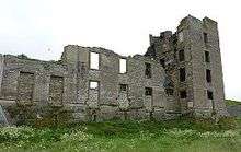
Thurso Castle


Thurso Castle (alternatively, Castrum De Thorsa, Castle of Ormly, and Castle of Ormlie) is a ruined 19th-century castle, located in Thurso, Caithness, in the Scottish Highlands. Situated in Thurso East, off Castletown Road, east of the River Thurso, the site can be seen from across the river.[1] The current castle ruins date to 1872; A large part was demolished in 1952, although there has been a fortress here since the 12th century. Part of the castle is still habitable and remains a home of the Viscounts Thurso.[2][3]
History
The name Thurso means "Thor's River" and was named by the Vikings.[4] There was a castle at Thurso East, which served as a residence of the earls of Orkney and Caithness, and it is probably the earthwork structure which was recorded in 1157 as the Thorsa castle.[5] A fire gutted it in the early 16th century,[6] and no vestige of it remains.[5]
The Arch, also known as Thurso Castle, was built in 1665 by George Sinclair, 6th Earl of Caithness. The contract between him and the master mason, Donald Ross, records the price as 600 merks.[5] The Thurso Lairdship was later held by Sir John Sinclair, 1st Baronet,[7] who erected a new structure, designed as a castle or fortress.[8] It was restored and enlarged in 1806 and 1835.[9]
The current structure, a Victorian Gothic ruin, was built in 1872 and demolished in 1952.[10]
Architecture

The previous structure, known as the Arch was described in 1802 as "the most ornamental piece of architecture in the north".[8] Robert Sinclair refers to the present castle as "a gallant ruined reminder of its former Gothic glory".[4] On the south side, a gatehouse and associated lodge are in fair condition. On the north side, adjacent to the river, are the remains of the north tower and a wing. Brick was added to the lower windows in the 20th century. The well is roughly 20 feet (6.1 m) deep.
Grounds
The site, of hilly ground known as Brown Hill,[1] is situated 0.5 miles (0.80 km) east of Thurso, close to the Atlantic Ocean atop of a rock several fathoms high.[5] A manse was erected at the site in 1818 using some of the stones from the castle.[6] About a mile to the northeast is Harald Tower, built in 1780, which served as a burial place for the Sinclairs of Thurso.[10]
References
- 1 2 "Thurso Castle ND 124-689 Caithness Scotland". CastleUK.Net. Retrieved 13 December 2014.
- ↑ "He went to Eton... worked as a skivvy... now the Viscount wants to speak for Scotland". Sunday Mail (Scotland). 4 April 1999.
- ↑ "John Thurso: The hereditary peer who became an MP". BBC. 22 February 2011.
- 1 2 Sinclair, Robert (11 June 2013). The Sinclairs of Scotland. AuthorHouse. p. 145. ISBN 978-1-4817-9623-1.
- 1 2 3 4 Anderson, William; Robertson, Joseph; Brichan, James Brodie; McNab, John (1855). Origines Parochiales Scotiae: pt. 1. Diocese of Argyle. Diocese of the Isles (Public domain ed.). W.H. Lizars. pp. 754–.
- 1 2 "Thurso, Princes Street, Castlegreen Manse, Castle Of Ormlie". Royal Commission on the Ancient and Historical Monuments of Scotland. Retrieved 14 December 2014.
- ↑ Carlisle, Nicholas (1813). A Topographical Dictionary of Scotland: And of the Islands in the British Seas (Public domain ed.). G. and W. Nicol. pp. 732–.
- 1 2 Cooke, George Alexander (1802). Topography of Great Britain: Or, British Traveller's Directory: Cornwall (Public domain ed.). C. Cooke. pp. 85–.
- ↑ "Thurso Castle". Royal Commission on the Ancient and Historical Monuments of Scotland. Retrieved 14 December 2014.
- 1 2 Miers, Richenda (2006). Scotland's Highlands and Islands. New Holland Publishers. pp. 193–. ISBN 978-1-86011-340-6.
Bibliography
- M. Coventry, The Castles of Scotland (2006), Fourth Edition, Birlinn Limited. ISBN 1-84158-449-5. Blz. 602-603.
External links
-
 Media related to Thurso Castle at Wikimedia Commons
Coordinates: 58°35′57.46″N 3°30′29.55″W / 58.5992944°N 3.5082083°W