Himalayas
| Himalayas | |
|---|---|
 The north face of Mount Everest seen from the path to the base camp in Tibet Autonomous Region, China | |
| Highest point | |
| Peak | Mount Everest (Nepal and China) |
| Elevation | 8,848 m (29,029 ft) |
| Coordinates | 27°59′17″N 86°55′31″E / 27.98806°N 86.92528°ECoordinates: 27°59′17″N 86°55′31″E / 27.98806°N 86.92528°E |
| Dimensions | |
| Length | 2,400 km (1,500 mi) |
| Geography | |
 The general location of the Himalayas mountain range
| |
| Countries | |
| State/Province | Asia |

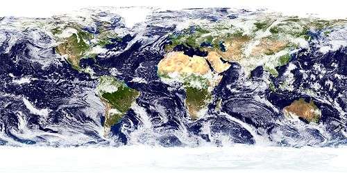
The Himalayas, or Himalaya, (/ˌhɪməˈleɪ.ə/ or /hɪˈmɑːləjə/) form a mountain range in Asia separating the plains of the Indian subcontinent from the Tibetan Plateau.
The Himalayan range has many of the Earth's highest peaks, including the highest, Mount Everest. The Himalayas include over fifty mountains exceeding 7,200 metres (23,600 ft) in elevation, including ten of the fourteen 8000m peaks. By contrast, the highest peak outside Asia – Aconcagua, in the Andes – is 6,961 metres (22,838 ft) tall.[1]
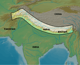
The Himalayan range is bordered on the northwest by the Karakoram and Hindu Kush ranges, on the north by the Tibetan Plateau, and on the south by the Indo-Gangetic Plain. The Himalayas are distinct from the other great ranges of central Asia, although sometimes the term Himalaya is loosely used to include the Karakoram and some of the other ranges. The Himalayas - inhabited by 52.7 milion people[2] - are spread across five countries: India, Nepal, Bhutan, China and Pakistan, with the first three countries having sovereignty over most of the range.[3] Some of the world's major rivers, the Indus, the Ganges, and the Tsangpo-Brahmaputra, rise in the Himalayas, and their combined drainage basin is home to roughly 600 million people. The Himalayas have profoundly shaped the cultures of South Asia; many Himalayan peaks are sacred in Hinduism and Buddhism.
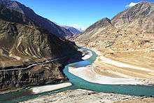
Lifted by the subduction of the Indian tectonic plate under the Eurasian Plate, the Himalayan mountain range runs, west-northwest to east-southeast, in an arc 2,400 kilometres (1,500 mi) long[4]. Its western anchor, Nanga Parbat, lies just south of the northernmost bend of Indus river. Its eastern anchor, Namcha Barwa, is just west of the great bend of the Tsangpo river. From the north, the chain is limited by a 50–60 kilometres (31–37 mi) wide tectonic valley called the Indus-Tsangpo Suture[5]. Towards the south the arc of the Himalaya is ringed by the very low Gangetic plain[6]. The range varies in width from 350 kilometres (220 mi) in the west (Kashmir) to 150 kilometres (93 mi) km in the east (Arunachal Pradesh)[7].

Name
The name of the range derives from the Sanskrit Himā-laya (हिमालय, "Abode of Snow"), from himá (हिम, "snow") and ā-laya (आलय, "receptacle, dwelling").[8] They are now known as the "Himalaya Mountains", usually shortened to the "Himalayas". Formerly, they were described in the singular as the "Himalaya". This was also previously transcribed "Himmaleh", as in Emily Dickinson's poetry[9] and Henry David Thoreau's essays.[10]
The mountains are known as the Himālaya in Nepali and Hindi (both written हिमालय), the Himalaya (ཧི་མ་ལ་ཡ་) or 'The Land of Snow' (གངས་ཅན་ལྗོངས་) in Tibetan, the Hamaleh Mountain Range (سلسلہ کوہ ہمالیہ) in Urdu, and the Ximalaya Mountain Range (t 喜馬拉雅山脈, s 喜马拉雅山脉, p Xǐmǎlāyǎ Shānmài) in Chinese.
Geography and key features
In the middle of the great curve of the Himalayan mountains lie the 8000m peaks of Dhaulagiri and Annapurna in Nepal, separated by the Kali Gandaki Gorge. The gorge splits the Himalayas into Western and Eastern sections both ecologically and orographically - the pass at the head of the Kali Gandaki, the Kora La is the lowest point on the ridgeline between Everest and K2. To the east of Annapurna are the 8000 m peaks of Manaslu and across the border in Tibet, Shishapangma. To the south of these lies Kathmandu, the capital of Nepal and the largest city in the Himalayas. East of the Kathmandu Valley lies valley of the Bhote/Sun Kosi river which rises in Tibet and provides the main overland route between Nepal and China - the Araniko Highway/China National Highway 318. Further east is the Mahalangur Himal with four of the world's six highest mountains, including the highest: Cho Oyu, Everest, Lhotse and Makalu. The Khumbu region, popular for trekking, is found here on the south-western approaches to Everest. The Arun river drains the northern slopes of these mountains, before turning south and flowing through the range to the east of Makalu.
In the far east of Nepal the Himalayas rise to the Kanchenjunga massif on the border with India, the third highest mountain in the world, the most easterly 8000 m summit and the highest point of India. The eastern side of Kanchenjunga is in the Indian state of Sikkim. Formerly an independent Kingdom, it lies on the main route from India to Lhasa, Tibet, which passes over the Nathu La pass into Tibet. East of Sikkim lies the ancient Buddhist Kingdom of Bhutan. The highest mountain in Bhutan is Gangkhar Puensum, which is also a strong candidate for the highest unclimbed mountain in the world. The Himalayas here are becoming increasingly rugged with heavily forested steep valleys. The Himalayas continue, turning slightly north east, through the disputed Indian State of Arunachal Pradesh as well as Tibet, before reaching their easterly conclusion in the peak of Namche Barwa, situated in Tibet inside the great bend of the Yarlang Tsangpo river. The high mountains the other side of the Tsangpo including Gyala Peri are also sometimes also included the Himalayas.
Going west from Dhaulagiri, Western Nepal is somewhat remote and lacks major high mountains, but is home to Rara Lake, the largest lake in Nepal. The Karnali River rises in Tibet but cuts through the centre of the region. Further west, the border with India follows the Sarda River and provides a trade route into China, where on the Tibetan plateau lies the high peak of Gurla Mandhata. Just across Lake Manasarovar from this lies the sacred Mount Kailash, which stands close to the source of the four main rivers of Himalayas and is revered in Hinduism, Buddhism, Jainism and Bonpo. In the newly created Indian state of Uttarkhand, the Himalayas rise again as the Garwhal Himalayas with the high peaks of Nanda Devi and Kamet . The state is also an important pilgrimage destination, with the source of the Ganges at Gangotri and the Yamuna at Yamunotri, and the temples at Badrinath and Kedarnath.
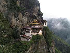
.JPG)
The next Himalayan Indian state, Himachal Pradesh, lacks very high mountains, but is noted for its hill stations, particularly Shimla, the summer capital of the British Raj, and Dharmasala, the centre of the Tibetan community in exile in India. This area marks the start of the Punjab Himalaya and the Sutlej river, the most easterly of the five tributaries of the Indus, cuts through the range here. Further west, the Himalayas form most of the southern portion of the disputed Indian State of Jammu & Kashmir. The twin peaks of Nun Kun are the only mountains over 7000 m in this part of the Himalayas. Beyond lies the renown Kashmir Valley and the town and lakes of Srinagar. Finally, the Himalayas cross the Line of Control into Pakistan and reach their western end in the dramatic 8000 m peak of Nanga Parbat, which rises over 7000 m above the Indus valley and is the most westerly of the 8000 m summits.
Geology

The Himalayan range is one of the youngest mountain ranges on the planet and consists mostly of uplifted sedimentary and metamorphic rock. According to the modern theory of plate tectonics, its formation is a result of a continental collision or orogeny along the convergent boundary between the Indo-Australian Plate and the Eurasian Plate. The Arakan Yoma highlands in Myanmar and the Andaman and Nicobar Islands in the Bay of Bengal were also formed as a result of this collision.
During the Upper Cretaceous, about 70 million years ago, the north-moving Indo-Australian plate (which has subsequently broken into the Indian Plate and the Australian plate[12]) was moving at about 15 cm per year. About 50 million years ago this fast moving Indo-Australian plate had completely closed the Tethys Ocean, the existence of which has been determined by sedimentary rocks settled on the ocean floor, and the volcanoes that fringed its edges. Since both plates were composed of low density continental crust, they were thrust faulted and folded into mountain ranges rather than subducting into the mantle along an oceanic trench.[11] An often-cited fact used to illustrate this process is that the summit of Mount Everest is made of marine limestone from this ancient ocean.[13]
Today, the Indian plate continues to be driven horizontally at the Tibetan Plateau, which forces the plateau to continue to move upwards.[14] The Indian plate is still moving at 67 mm per year, and over the next 10 million years it will travel about 1,500 km into Asia. About 20 mm per year of the India-Asia convergence is absorbed by thrusting along the Himalaya southern front. This leads to the Himalayas rising by about 5 mm per year, making them geologically active. The movement of the Indian plate into the Asian plate also makes this region seismically active, leading to earthquakes from time to time.
During the last ice age, there was a connected ice stream of glaciers between Kangchenjunga in the east and Nanga Parbat in the west.[15][16] In the west, the glaciers joined with the ice stream network in the Karakoram, and in the north, joined with the former Tibetan inland ice. To the south, outflow glaciers came to an end below an elevation of 1,000–2,000 metres (3,300–6,600 ft).[15][17] While the current valley glaciers of the Himalaya reach at most 20 to 32 kilometres (12 to 20 mi) in length, several of the main valley glaciers were 60 to 112 kilometres (37 to 70 mi) long during the ice age.[15] The glacier snowline (the altitude where accumulation and ablation of a glacier are balanced) was about 1,400–1,660 metres (4,590–5,450 ft) lower than it is today. Thus, the climate was at least 7.0 to 8.3 °C (12.6 to 14.9 °F) colder than it is today.[18]
Hydrology

The Himalayas contain the third-largest deposit of ice and snow in the world, after Antarctica and the Arctic.[19] The Himalayan range encompasses about 15,000 glaciers, which store about 12,000 km3 (3,000 cubic miles) of fresh water.[20] Its glaciers include the Gangotri and Yamunotri (Uttarakhand) and Khumbu glaciers (Mount Everest region), Langtang glacier (Langtang region) and Zemu (Sikkim).
Owing to the mountains' latitude near the Tropic of Cancer, the permanent snow line is among the highest in the world at typically around 5,500 metres (18,000 ft).[21] In contrast, equatorial mountains in New Guinea, the Rwenzoris and Colombia have a snow line some 900 metres (2,950 ft) lower.[22] The higher regions of the Himalayas are snowbound throughout the year, in spite of their proximity to the tropics, and they form the sources of several large perennial rivers.
Despite their scale the Himalayas do not form a major watershed, and a number of rivers cut through the range, particularly in the eastern part of the range. As a result, the main ridge of the Himalayas is not clearly defined, and mountain passes are not as significant for traversing the range as with other mountain ranges. The rivers of the Himalayas drain into two large river systems:
- The western rivers combine into the Indus Basin. The Indus itself forms the northern and western boundaries of the Himalayas. It begins in Tibet at the confluence of Sengge and Gar rivers and flows north-west through India into Pakistan before turning south-west to the Arabian Sea. It is fed by several major tributaries draining the southern slopes of the Himalayas, including the Jhelum, the Chenab, the Ravi, the Beas, and the Sutlej rivers.
- The other Himalayan rivers drain the Ganges-Brahmaputra Basin. Its main rivers are the Ganges, the Brahmaputra and the Yamuna, as well as other tributaries. The Brahmaputra originates as the Yarlung Tsangpo River in western Tibet, and flows east through Tibet and west through the plains of Assam. The Ganges and the Brahmaputra meet in Bangladesh, and drain into the Bay of Bengal through the world's largest river delta, the Sunderbans.[23]
The easternmost Himalayan rivers feed the Irrawaddy River, which originates in eastern Tibet and flows south through Myanmar to drain into the Andaman Sea.
The Salween, Mekong, Yangtze and Yellow River all originate from parts of the Tibetan Plateau that are geologically distinct from the Himalaya mountains, and are therefore not considered true Himalayan rivers. Some geologists refer to all the rivers collectively as the circum-Himalayan rivers.[24] In recent years, scientists have monitored a notable increase in the rate of glacier retreat across the region as a result of global climate change.[25] For example, glacial lakes have been forming rapidly on the surface of debris-covered glaciers in the Bhutan Himalaya during the last few decades. Although the effect of this will not be known for many years, it potentially could mean disaster for the hundreds of millions of people who rely on the glaciers to feed the rivers during the dry seasons.[26]
Lakes

The Himalayan region is dotted with hundreds of lakes. Most lakes are found at altitudes of less than 5,000 m, with the size of the lakes diminishing with altitude. Tilicho Lake in Nepal in the Annapurna massif is one of the highest lakes in the world. Pangong Tso, which is spread across the border between India and China, and Yamdrok Tso, located in central Tibet, are amongst the largest with surface areas of 700 km², and 638 km², respectively. Other notable lakes include She-Phoksundo Lake in the Shey Phoksundo National Park of Nepal, Gurudongmar Lake, in North Sikkim, Gokyo Lakes in Solukhumbu district of Nepal and Lake Tsongmo, near the Indo-China border in Sikkim.
Some of the lakes present a danger of a glacial lake outburst flood. The Tsho Rolpa glacier lake in the Rowaling Valley, in the Dolakha District of Nepal, is rated as the most dangerous. The lake, which is located at an altitude of 4,580 metres (15,030 ft) has grown considerably over the last 50 years due to glacial melting.[27][28]
The mountain lakes are known to geographers as tarns if they are caused by glacial activity. Tarns are found mostly in the upper reaches of the Himalaya, above 5,500 metres.[29]
Climate
The vast size, huge altitude range and complex topography of the Himalayas mean they experience a wide range of climates, from humid subtropical in the foothills to cold, dry desert conditions on the Tibetan side of the range.
For much of Himalayas - that on the south side of the high mountains, except in the furthest west, the most characteristic feature of the climate is the monsoon. Heavy rain arrives on the south-west monsoon in June, and persists until September. The monsoon can seriously impact transport and cause major landslides. It restricts tourism - the trekking and mountaineering season is limited to either before the monsoon in April/May or after the monsoon in October/November (autumn). In Nepal and Sikkim, there are often considered to be five seasons: summer, monsoon, autumn (or post-monsoon), winter and spring.
Using the Koppen climate classification, the lower elevations of the Himalayas, reaching in mid elevations in central Nepal (including the Kathmandu valley), are classified as Cwa, Humid subtropical climate with dry winters. Higher up, most of the Himalayas have a subtropical highland climate (Cwb).
In the furthest west of the Himalayas, in the west of the Kashmir valley and the Indus valley, the South Asian monsoon is no longer a dominant factor and most precipitation falls in the spring. Srinagar receives around 723 millimetres (28 in) around half the rainfall of locations such as Shimla and Kathmandu, with the wettest months being March and April.
The northern side of the Himalayas, also known as the Tibetan Himalaya, is dry, cold and generally wind swept particularly in the west where it has a cold desert climate. The vegetation is sparse and stunted and the winters are severely cold. Most of the snowfall is in the form of snow during late winter and spring months.
Local impacts on climate are significant throughout the Himalayas. Temperatures fall by 6.5 °C (11.7 °F) for every 1000m rise in altitude. This gives rise to a variety of climates from nearly tropical in the foothills to tundra and permanent snow and ice. Local climate is also be affected by the topography: The leeward side of the mountains receive less rain while the well exposed slopes get heavy rainfall and the rain shadow of large mountains can be significant, for example leading to near desert conditions in the Upper Mustang which is sheltered from the monsoon rains by the Annapurna and Dhaulagiri massifs and has annual precipitation of around 300mm, while Pokhara on the southern side of the massifs has substantial rainfall (3,900mm/year). Thus although annual precipitation is generally higher in east than the west, local variations are often more important.
The Himalayas have a profound effect on the climate of the Indian subcontinent and the Tibetan Plateau. They prevent frigid, dry winds from blowing south into the subcontinent, which keeps South Asia much warmer than corresponding temperate regions in the other continents. It also forms a barrier for the monsoon winds, keeping them from traveling northwards, and causing heavy rainfall in the Terai region. The Himalayas are also believed to play an important part in the formation of Central Asian deserts, such as the Taklamakan and Gobi.[30]
Ecology

The flora and fauna of the Himalayas vary with climate, rainfall, altitude, and soils. The climate ranges from tropical at the base of the mountains to permanent ice and snow at the highest elevations. The amount of yearly rainfall increases from west to east along the southern front of the range. This diversity of altitude, rainfall and soil conditions combined with the very high snow line supports a variety of distinct plant and animal communities. The extremes of high altitude (low atmospheric pressure) combined with extreme cold favor extremophile organisms.[31]
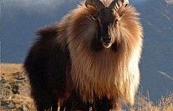

At high altitudes, the elusive and endangered snow leopard is the main predator. Its prey includes members of the goat family grazing on the alpine pastures and living on the rocky terrain, notably the endemic bharal or Himalayan blue sheep. The Himalayan musk deer is also found at high altitude. Hunted for its musk, it is now rare and endangered. Other endemic or near endemic herbivores include the Himalayan tahr, the takin, the Himalayan serow, and the Himalayan goral. The critically endangered Himalayan subspecies of the brown bear is found sporadically across the range as is the Asian black bear. In the mountainous mixed deciduous and conifer forests of the eastern Himalayas, Red panda feed in the dense understories of bamboo. Lower down the forests of the foothills are inhabited by several different primates, including the endangered Gee's golden langur and the Kashmir gray langur, with highly restricted ranges in the east and west of the Himalayas respectively.
The unique floral and faunal wealth of the Himalayas is undergoing structural and compositional changes due to climate change. The increase in temperature is shifting various species to higher elevations. The oak forest is being invaded by pine forests in the Garhwal Himalayan region. There are reports of early flowering and fruiting in some tree species, especially rhododendron, apple and box myrtle. The highest known tree species in the Himalayas is Juniperus tibetica located at 4,900 metres (16,080 ft) in Southeastern Tibet.[32]
Culture
The Himalayan population belongs to four distinct cultural groups, who throughout history have systematically penetrated the isolated indigenous Himalayan population. Those migrating cultures – Hindu (Indian), Buddhist (Tibetan), Islamic (Afghanistan–Iran) and Animist (Burmese and south-eastern Asian) – without any doubt have created here their own individual and unique place[33]. Their current arrangement, though with a few exceptions, is linked to specific geographical regions, and the relative altitude at which they occur.
There are many cultural aspects of the Himalayas. For the Hindus, the Himalayas are personified as Himavath, the father of the goddess Parvati.[34] The Himalayas is also considered to be the father of the river Ganges. The Mountain Kailash is a sacred peak to the Hindus and is where the Lord Shiva is believed to live.[35] Two of the most sacred places of pilgrimage for the Hindus is the temple complex in Pashupatinath and Muktinath, also known as Saligrama because of the presence of the sacred black rocks called saligrams.[36]
The Buddhists also lay a great deal of importance on the mountains of the Himalayas. Paro Taktsang is the holy place where Buddhism started in Bhutan.[35] The Muktinath is also a place of pilgrimage for the Tibetan Buddhists. They believe that the trees in the poplar grove came from the walking sticks of eighty-four ancient Indian Buddhist magicians or mahasiddhas. They consider the saligrams to be representatives of the Tibetan serpent deity known as Gawo Jagpa.[37]
The Himalayan people’s diversity shows in many different ways. It shows through their architecture, their languages and dialects, their beliefs and rituals, as well as their clothing.[37] The shapes and materials of the people’s homes reflect their practical needs and the beliefs. Another example of the diversity amongst the Himalayan peoples is that handwoven textiles display colors and patterns unique to their ethnic backgrounds. Finally, some people place a great importance on jewelry. The Rai and Limbu women wear big gold earrings and nose rings to show their wealth through their jewelry.[37]
Religions of the region
Several places in the Himalayas are of religious significance in Hinduism, Buddhism, Jainism and Sikhism. A notable example of a religious site is Paro Taktsang, where Padmasambhava is said to have founded Buddhism in Bhutan.[38] Padmasambhava is also worshipped as the patron saint of Sikkim. There are also Muslim and Hindhu Shaivite Kashmiri Pandit in the area of Kashmir.
In Hinduism, the Himalayas have been personified as the king of all Mountain - "Giriraj Himavat", father of Ganga and Parvati (form of Adi Shakti Durga).[39]
A number of Vajrayana Buddhist sites are situated in the Himalayas, in Tibet, Bhutan and in the Indian regions of Ladakh, Sikkim, Arunachal Pradesh, Spiti and Darjeeling. There were over 6,000 monasteries in Tibet, including the residence of the Dalai Lama.[40] Bhutan, Sikkim and Ladakh are also dotted with numerous monasteries. The Tibetan Muslims have their own mosques in Lhasa and Shigatse.[41]
Resources
The Himalayas are home to a diversity of medicinal resources. Plants from the forests have been used for millennia to treat conditions ranging from simple coughs to snake bites.[36] Different parts of the plants - root, flower, stem, leaves, and bark - are used as remedies for different ailments. For example, a bark extract from an abies pindrow tree is used to treat coughs and bronchitis. Leaf and stem paste from an arachne cordifolia is used for wounds and as an antidote for snake bites. The bark of a callicarpa arborea is used for skin ailments.[36] Nearly a fifth of the gymnosperms, angiosperms, and pteridophytes in the Himalayas are found to have medicinal properties, and more are likely to be discovered.[36]
Most of the population in some Asian and African countries depend on medicinal plants rather than prescriptions and such (Gupta and Sharma, vii).[34] Since so many people use medicinal plants as their only source of healing in the Himalayas, the plants are an important source of income. This contributes to economic and modern industrial development both inside and outside the region (Gupta and Sharma, 5).[34] The only problem is that locals are rapidly clearing the forests on the Himalayas for wood, often illegally (Earth Island Journal, 2).[42] This means that the number of medicinal plants is declining and that some of them might become rarer or, in some cases, go extinct.
Although locals are clearing out portions of the forests in the Himalayas, there is still a large amount of greenery ranging from the tropical forests to the Alpine forests. These forests provide wood for fuel and other raw materials for use by industries. There are also many pastures for animals to graze upon (Mohita, sec. Forest and Wealth).[43] The many varieties of animals that live in these mountains do so based on the elevation. For example, elephants and rhinoceros live in the lower elevations of the Himalayas, also called the Terai region. Also, found in these mountains are the Kashmiri stag, black bears, musk deer, langur, and snow leopards. The Tibetan yak are also found on these mountains and are often used by the people for transportation. However, the populations of many of these animals and still others are declining and are on the verge of going extinct (Admin, sec. Flora and Fauna).[35]
The Himalayas are also a source of many minerals and precious stones. Amongst the tertiary rocks, are vast potentials of mineral oil. There is coal located in Kashmir, and precious stones located in the Himalayas. There is also gold, silver, copper, zinc, and many other such minerals and metals located in at least 100 different places in these mountains (Mohita, sec. Minerals).[43]
See also
References
- ↑ Yang, Qinye; Zheng, Du (2004). Himalayan Mountain System. ISBN 9787508506654. Retrieved 30 July 2016.
- ↑ Apollo, M. (2017). The population of Himalayan regions – by the numbers: Past, present and future. [In:] R. Efe, M. Öztürk (eds.), Contemporary Studies in Environment and Tourism, Chapter: 9 (pp.143-159). Publisher: Cambridge Scholars Publishing. https://books.google.pl/books?hl=en&lr=&id=bmPXDgAAQBAJ&oi=fnd&pg=PA145&ots=oKLCNOveUc&sig=0K2GQrOSN9dMCGMPrR3ryj7Adgo&redir_esc=y#v=onepage&q&f=false
- ↑ Bishop, Barry. "Himalayas (mountains, Asia)". Encyclopædia Britannica. Retrieved 30 July 2016.
- ↑ Wadia, D. N. (1931). The syntaxis of the northwest Himalaya: its rocks, tectonics and orogeny. Record Geol. Survey of India 65(2): 189-220.
- ↑ Valdiya, K. S. (1998). Dynamic Himalaya . Hyderabad: Universities Press.
- ↑ Le Fort, P. (1975). Himalayas: The collided range. Present knowledge of the continental arc. American Journal Science 275A: 1-44. http://earth.geology.yale.edu/~ajs/1975/ajs_275A_1.pdf/1.pdf
- ↑ Apollo, M. (2017). The population of Himalayan regions – by the numbers: Past, present and future. [In:] R. Efe, M. Öztürk (eds.), Contemporary Studies in Environment and Tourism, Chapter: 9 (pp.143-159). Publisher: Cambridge Scholars Publishing. https://books.google.pl/books?hl=en&lr=&id=bmPXDgAAQBAJ&oi=fnd&pg=PA145&ots=oKLCNOveUc&sig=0K2GQrOSN9dMCGMPrR3ryj7Adgo&redir_esc=y#v=onepage&q&f=false
- ↑ "Definition of Himalayas". Oxford Dictionaries Online. Retrieved 9 May 2011.
- ↑ Dickinson, Emily, "The Himmaleh was known to stoop".
- ↑ Thoreau, Henry David (1849), A Week on the Concord and Merrimack Rivers.
- 1 2 "The Himalayas: Two continents collide". USGS. 5 May 1999. Retrieved 3 January 2015.
- ↑ (1995) Geologists Find: An Earth Plate Is Breaking in Two
- ↑ A site which uses this dramatic fact first used in illustration of "deep time" in John McPhee's book Basin and Range
- ↑ "Plate Tectonics -The Himalayas". The Geological Society. Retrieved 13 September 2016.
- 1 2 3 Kuhle, M. (2011). "The High Glacial (Last Ice Age and Last Glacial Maximum) Ice Cover of High and Central Asia, with a Critical Review of Some Recent OSL and TCN Dates". In Ehlers, J.; Gibbard, P.L.; Hughes, P.D. Quaternary Glaciation – Extent and Chronology, A Closer Look. Amsterdam: Elsevier BV. pp. 943–965.
- ↑ glacier maps downloadable
- ↑ Kuhle, M. (1987). "Subtropical mountain- and highland-glaciation as ice age triggers and the waning of the glacial periods in the Pleistocene". GeoJournal. 14 (4): 393–421. doi:10.1007/BF02602717.
- ↑ Kuhle, M. (2005). "The maximum Ice Age (Würmian, Last Ice Age, LGM) glaciation of the Himalaya – a glaciogeomorphological investigation of glacier trim-lines, ice thicknesses and lowest former ice margin positions in the Mt. Everest-Makalu-Cho Oyu massifs (Khumbu- and Khumbakarna Himal) including informations on late-glacial-, neoglacial-, and historical glacier stages, their snow-line depressions and ages". GeoJournal. Dordrecht: Kluwer. 62 (3–4): 193–650. doi:10.1007/s10708-005-2338-6.
- ↑ "The Himalayas". Nature on PBS. Retrieved 21 January 2014.
- ↑ "the Himalayan Glaciers". Fourth assessment report on climate change. IPPC. 2007. Retrieved 22 January 2014.
- ↑ Shi, Yafeng; Xie, Zizhu; Zheng, Benxing; Li, Qichun (1978). "Distribution, Feature and Variations of Glaciers in China" (PDF). World Glacier Inventory. Riederalp Workshop. Archived from the original (PDF) on 16 December 2012.
- ↑ Henderson-Sellers, Ann; McGuffie, Kendal. The Future of the World's Climate: A Modelling Perspective. pp. 199–201. ISBN 9780123869173.
- ↑ "Sunderbans the world's largest delta". gits4u.com. Retrieved 3 January 2015.
- ↑ Gaillardet, J.; Métivier, F.; Lemarchand, D.; Dupré, B.; Allègre, C. J.; Li, W.; Zhao, J. (2003). "Geochemistry of the Suspended Sediments of Circum-Himalayan Rivers and Weathering Budgets over the Last 50 Myrs" (PDF). Geophysical Research Abstracts. European Geophysical Society. 5. Bibcode:2003EAEJA....13617G. Abstract 13617. Retrieved 4 November 2006.
- ↑ "Vanishing Himalayan Glaciers Threaten a Billion". Planet Ark. 5 June 2007. Retrieved 17 April 2009.
- ↑ "Glaciers melting at alarming speed". People's Daily Online. 24 July 2007. Retrieved 17 April 2009.
- ↑ Photograph of Tsho Rolpa
- ↑ Tsho Rolpa
- ↑ Drews, Carl. "Highest Lake in the World". Retrieved 14 November 2010.
- ↑ Devitt, Terry (3 May 2001). "Climate shift linked to rise of Himalayas, Tibetan Plateau". University of Wisconsin–Madison News. Retrieved 1 November 2011.
- ↑ Hogan, C. Michael (2010). Monosson, E., ed. "Extremophile". Encyclopedia of Earth. Washington DC: National Council for Science and the Environment.
- ↑ Miehe, Georg; Miehe, Sabine; Vogel, Jonas; Co, Sonam; Duo, La (May 2007). "Highest Treeline in the Northern Hemisphere Found in Southern Tibet" (PDF). Mountain Research and Development. 27 (2): 169–173. doi:10.1659/mrd.0792. Archived from the original (PDF) on 6 June 2013.
- ↑ Apollo, M. (2017). The population of Himalayan regions – by the numbers: Past, present and future. [In:] R. Efe, M. Öztürk (eds.), Contemporary Studies in Environment and Tourism, Chapter: 9 (pp.143-159). Publisher: Cambridge Scholars Publishing. https://books.google.pl/books?hl=en&lr=&id=bmPXDgAAQBAJ&oi=fnd&pg=PA145&dq=related:FmViXjXaASwJ:scholar.google.com/&ots=oKLCNOteR9&sig=A83K5prI2vJp06Sz17E2P15wtRw&redir_esc=y#v=onepage&q&f=false
- 1 2 3 Gupta, Pankaj and Sharma, Vijay Kumar, Author. Healing Traditions of the Northwestern Himalayas. 2014. Print. SpringerBriefs in Environmental Science.
- 1 2 3 Admin. "King of Mountains: The Himalayas." Knowledge Of India. N.p., 20 Mar. 2015. Web. 10 Nov. 2015.
- 1 2 3 4 Jahangeer A. Bhat, Munesh Kumar and Rainer W. Bussmann (2 January 2013). "Ecological status and traditional knowledge of medicinal plants in Kedarnath Wildlife Sanctuary of Garhwal Himalaya, India". Journal of Ethnobiology and Ethnomedicine. BioMed Central. Retrieved 22 January 2016.
- 1 2 3 Zurick, David, Julsun Pacheco, Basanta Raj. Shrestha, and Birendra Bajracharya. Illustrated Atlas of the Himalaya. Lexington: U of Kentucky, 2006. Google Books. The University Press of Kentucky. Web. 11 Nov. 2015.
- ↑ Pommaret, Francoise (2006). Bhutan Himalayan Mountains Kingdom (5th ed.). Odyssey Books and Guides. pp. 136–7. ISBN 978-9622178106.
- ↑ Dallapiccola, Anna (2002). Dictionary of Hindu Lore and Legend. ISBN 0-500-51088-1.
- ↑ "Tibetan monks: A controlled life". BBC News. 20 March 2008.
- ↑ "Mosques in Lhasa, Tibet". People's Daily Online. 27 October 2005.
- ↑ "Himalayan Forests Disappearing." Earth Island Journal 21.4 (2006): 7-8. Academic Search Complete. Web. 2 Nov. 2015.
- 1 2 Mohita, Negi. "Himalayas: 10 Significance of the Himalaya Mountains to India (Notes)."YourArticleLibrarycom The Next Generation Library. N.p., 21 Nov. 2013. Web. 11 Nov. 2015.
Further reading
- Aitken, Bill, Footloose in the Himalaya, Delhi, Permanent Black, 2003. ISBN 81-7824-052-1
- Berreman, Gerald Duane, Hindus of the Himalayas: Ethnography and Change, 2nd rev. ed., Delhi, Oxford University Press, 1997.
- Bisht, Ramesh Chandra, Encyclopedia of the Himalayas, New Delhi, Mittal Publications, c2008.
- Everest, the IMAX movie (1998). ISBN 0-7888-1493-1
- Fisher, James F., Sherpas: Reflections on Change in Himalayan Nepal, 1990. Berkeley, University of California Press, 1990. ISBN 0-520-06941-2
- Gansser, Augusto, Gruschke, Andreas, Olschak, Blanche C., Himalayas. Growing Mountains, Living Myths, Migrating Peoples, New York, Oxford: Facts On File, 1987. ISBN 0-8160-1994-0 and New Delhi: Bookwise, 1987.
- Gupta, Raj Kumar, Bibliography of the Himalayas, Gurgaon, Indian Documentation Service, 1981
- Hunt, John, Ascent of Everest, London, Hodder & Stoughton, 1956. ISBN 0-89886-361-9
- Isserman, Maurice and Weaver, Stewart, Fallen Giants: The History of Himalayan Mountaineering from the Age of Empire to the Age of Extremes. Yale University Press, 2008. ISBN 978-0-300-11501-7
- Ives, Jack D. and Messerli, Bruno, The Himalayan Dilemma: Reconciling Development and Conservation. London / New York, Routledge, 1989. ISBN 0-415-01157-4
- Lall, J.S. (ed.) in association with Moddie, A.D., The Himalaya, Aspects of Change. Delhi, Oxford University Press, 1981. ISBN 0-19-561254-X
- Nandy, S.N., Dhyani, P.P. and Samal, P.K., Resource Information Database of the Indian Himalaya, Almora, GBPIHED, 2006.
- Palin, Michael, Himalaya, London, Weidenfeld & Nicolson Illustrated, 2004. ISBN 0-297-84371-0
- Swami Sundaranand, Himalaya: Through the Lens of a Sadhu. Published by Tapovan Kuti Prakashan (August 2001). ISBN 81-901326-0-1
- Swami Tapovan Maharaj, Wanderings in the Himalayas, English Edition, Madras, Chinmaya Publication Trust, 1960. Translated by T.N. Kesava Pillai.
- Tilman, H. W., Mount Everest, 1938, Cambridge University Press, 1948.
- 'The Mighty Himalaya: A Fragile Heritage,’ National Geographic, 174:624–631 (November 1988).
- Turner, Bethan, et al. Seismicity of the Earth 1900–2010: Himalaya and Vicinity. Denver, United States Geological Survey, 2013.
External links
| Wikiquote has quotations related to: Himalayas |
| Wikimedia Commons has media related to: |
| Wikivoyage has a travel guide for Himalayas. |
- The Digital Himalaya research project at Cambridge and Yale
- Pierre Dèzes (1999). "The making of the Himalaya and major tectonic subdivisions". The geology of Zanskar.
- Geology of the Himalayan mountains
- Birth of the Himalaya
- Some notes on the formation of the Himalaya
- Pictures from a trek in Annapurna (film by Ori Liber)
- Geology of Nepal Himalaya
- South Asia's Troubled Waters Journalistic project at the Pulitzer Centre for Crisis Reporting
- Die Berge des Himalaya The mountains of Himalaya (in German - easily translatable online)
| Branches |
| ||||||
|---|---|---|---|---|---|---|---|
| Techniques and tools | |||||||
| Institutions |
| ||||||
| Education | |||||||
| |||||||