Texas State Highway 224
| ||||
|---|---|---|---|---|
 | ||||
| Route information | ||||
| Maintained by TxDOT | ||||
| Length: | 14.901 mi[1] (23.981 km) | |||
| Existed: | 1979 – present | |||
| Major junctions | ||||
| West end: |
| |||
| East end: |
| |||
| Highway system | ||||
| ||||
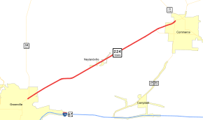
State Highway 224 or SH 224 is a Texas state highway running from Greenville northeast to Commerce. The route was designated in 1979 as a renumbering of a portion of its parent SH 24 when it was rerouted southward from Commerce along SH 50.
Previous Routes
In 1936, SH 224 was a route from SH 6 to the A&M University Administration Building. This route was cancelled by 1939, and it was redesignated in 1940 as Spur 86.
Junction list
The entire route is in Hunt County.
| Location | mi | km | Destinations | Notes | |
|---|---|---|---|---|---|
| Greenville | 0.0 | 0.0 | |||
| | 1.9 | 3.1 | |||
| | 3.8 | 6.1 | |||
| Neylandville | 6.8 | 10.9 | |||
| Commerce | 11.3 | 18.2 | unnumbered eastbound exit | ||
| 12.2 | 19.6 | ||||
| 13.0 | 20.9 | ||||
| 13.6 | 21.9 | interchange | |||
| 13.8 | 22.2 | ||||
| 14.9 | 24.0 | ||||
| 1.000 mi = 1.609 km; 1.000 km = 0.621 mi | |||||
References
- ↑ Transportation Planning and Programming Division (n.d.). "State Highway No. 224". Highway Designation Files. Texas Department of Transportation. Retrieved 2008-04-03.
This article is issued from
Wikipedia.
The text is licensed under Creative Commons - Attribution - Sharealike.
Additional terms may apply for the media files.
