Teistungen
| Teistungen | ||
|---|---|---|
| ||
 Teistungen | ||
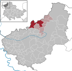
Location of Teistungen within Eichsfeld district 
 | ||
| Coordinates: 51°28′11″N 10°15′57″E / 51.46972°N 10.26583°ECoordinates: 51°28′11″N 10°15′57″E / 51.46972°N 10.26583°E | ||
| Country | Germany | |
| State | Thuringia | |
| District | Eichsfeld | |
| Municipal assoc. | Lindenberg/Eichsfeld | |
| Government | ||
| • Mayor | Ursula Apel (CDU) | |
| Area | ||
| • Total | 25.94 km2 (10.02 sq mi) | |
| Elevation | 200 m (700 ft) | |
| Population (2015-12-31)[1] | ||
| • Total | 2,497 | |
| • Density | 96/km2 (250/sq mi) | |
| Time zone | CET/CEST (UTC+1/+2) | |
| Postal codes | 37339 | |
| Dialling codes | 036071 | |
| Vehicle registration | EIC | |
| Website | www.teistungen.de | |
Teistungen is a municipality in the district of Eichsfeld in Thuringia, Germany.
Teistungen was first mentioned in 1090 as the site of Teistungenburg monastery, a filiation of Beuren monastery. The old monastery buildings were demolished in 1975.
It is located in the historical Eichsfeld, formerly a remote exclave of the Electorate of Mainz in Northern Germany. In 1283 the fief was acquired by the knightly family von Hagen who resided in nearby Westernhagen Castle at Berlingerode (destroyed in 1525). The Westernhagen family built two tower houses here that were later replaced by manor houses. Between 1802 and 1807 the Eichsfeld became part of the Kingdom of Westphalia, then until 1945 of the Prussian Province of Saxony, thereafter it formed part of East Germany. Since 1990 it is part of the state of Thuringia.

