Teignbridge
Coordinates: 50°34′55″N 3°37′41″W / 50.582°N 3.628°W
| Teignbridge District | |
|---|---|
| Non-metropolitan district | |
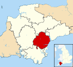
 Teignbridge shown within Devon | |
| Sovereign state | United Kingdom |
| Constituent country | England |
| Region | South West England |
| Non-metropolitan county | Devon |
| Status | Non-metropolitan district |
| Admin HQ | Newton Abbot |
| Incorporated | 1 April 1974 |
| Government | |
| • Type | Non-metropolitan district council |
| • Body | Teignbridge District Council |
| • Leadership | Leader & Cabinet (Conservative) |
| • MPs |
Anne Marie Morris Mel Stride |
| Area | |
| • Total | 246.3 sq mi (637.9 km2) |
| Area rank | 56th (of 326) |
| Population (mid-2016 est.) | |
| • Total | 129,900 |
| • Rank | 166th (of 326) |
| • Density | 530/sq mi (200/km2) |
| • Ethnicity | 96.2% White British |
| Time zone | GMT (UTC0) |
| • Summer (DST) | BST (UTC+1) |
| ONS code |
18UH (ONS) E07000045 (GSS) |
| OS grid reference | SX8475477137 |
| Website |
www |
Teignbridge is a local government district in Devon, England. Its council is based in Newton Abbot.
Other towns in the district include Ashburton, Dawlish and Teignmouth. It is named for the old Teignbridge hundred.
The district was formed on 1 April 1974, under the Local Government Act 1972, as a merger of the Ashburton, Buckfastleigh, Dawlish, Newton Abbot and Teignmouth urban districts along with Newton Abbot Rural District and part of St Thomas Rural District.
Politics
Elections to the borough council are held every four years, with all of the 46 seats on the council being elected at each election. The council had been under no overall control since the 1983, until the Conservatives gained a majority in the 2011 elections. The political composition of the borough has been as follows:
| Date | Conservative | +/- | Liberal Democrat | +/- | Independent | +/- | Control | |||
| 2003[1] | 13 | 16 | 14 | NOC | ||||||
| 2007[2] | 18 | +5 | 21 | +5 | 7 | -7 | NOC | |||
| 2011[3] | 26 | +8 | 13 | -8 | 7 | = | NOC | |||
| 2015[4] | 29 | +3 | 12 | -1 | 5 | -2 | NOC | |||
| Dec 2016[5][6] | 27 | -2 | 14 | +2 | 5 | = | NOC | |||
Settlements
Teignbridge contains the following towns and villages:
- Abbotskerswell
- Ashburton
- Ashcombe
- Ashton
- Bickington
- Bishopsteignton
- Bovey Tracey
- Bridford
- Brimley
- Broadhempston
- Buckfastleigh
- Buckland in the Moor
- Christow
- Chudleigh
- Cockwood
- Coffinswell
- Combe Fishacre
- Combeinteignhead
- Dainton
- Dawlish
- Dawlish Warren
- Denbury
- Doddiscombsleigh
- Dunchideock
- Dunsford
- Exminster
- Forder Green
- Gabwell
- Gappah
- Haytor vale
- Heathfield
- Hennock
- Holcombe
- Humber
- Ide
- Ideford
- Ilsington
- Ipplepen
- Kenn
- Kennford
- Kenton
- Kingskerswell
- Kingsteignton
- Liverton
- Lustleigh
- Luton
- Mamhead
- Manaton
- Moretonhampstead
- Nadderwater
- Netherton
- Newton Abbot
- North Bovey
- North Whilborough
- Ogwell
- Pathfinder Village
- Ponsworthy
- Poundsgate
- Powderham
- Ringmore
- Shaldon
- Shillingford Abbot
- Shillingford St George
- Sigford
- South Knighton
- Starcross
- Stokeinteignhead
- Tedburn St Mary
- Teign Village
- Teigngrace
- Teignmouth
- Torbryan
- Trusham
- Water
- Whitestone
- Widecombe-in-the-Moor
- Woodland
References
- ↑ "District Election Results, 2003". Teignbridge District Council. Retrieved 5 January 2017.
- ↑ "District Election Results, 2007". Teignbridge District Council. Retrieved 5 January 2017.
- ↑ "District Election Results, 2011". Teignbridge District Council. Retrieved 5 January 2017.
- ↑ "District Election Results, 2015". Teignbridge District Council. Retrieved 5 January 2017.
- ↑ "District and Town Council By-Elections - 15 December 2016". Teignbridge District Council. Retrieved 5 January 2017.
- ↑ "Lib Dems win two seats in Teignbridge Council". Torquay Herald Express. Retrieved 5 January 2017.