Taufers Railway
| Tauferer Bahn | |
|---|---|
 | |
| Overview | |
| Type | passenger/freight |
| Status | abandoned |
| Termini |
Bruneck Taufers |
| Stations | 7 |
| Operation | |
| Opened | July 21, 1908 |
| Closed | February 2, 1957 |
| Operator(s) | Austrian Southern Railway / Ferrovie dello Stato |
| Technical | |
| Line length | 15.40 km (9.57 mi) |
| Track gauge | 1,435 mm (4 ft 8 1⁄2 in) |
| Electrification | 800 Volt direct current |
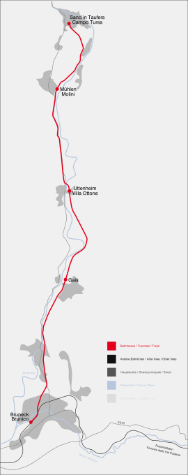
The Tauferer Bahn (English: Taufers Railway) connected Taufers with the city of Bruneck and the Pusterer Bahn.
Track
Just after leaving the station of Bruneck and after crossing the Rienz, the track followed the Ahr river until the final station in Taufers. Only two bridges were necessary to build the line. One in Uttenheim over the Ahr river and one in Mühlen in Taufers over the Mühlwalder brook. The train stations coming from Bruneck to Taufers were St. Georgen, Gais, Uttenheim, Mühlen in Taufers, Kematen and Taufers.
History
The railroad was built by the Tirolean railway engineer Josef Riehl and from 1907 onwards 300 people were working on the construction site. The needed 800 Volt direct current for the train where produced by a small power plant in the valley using the water of the Ahr River. Until World War I the service was provided by the Austrian Südbahngesellschaft, which also ran the Brennerbahn and the Pusterer Bahn. The cars had two motors with each 48 Kilowatt power. Because the line had only one track from one end to the other only one train could drive back and forward. Six trains daily got from Bruneck to Taufers and vice versa in 50 minutes. Like many other secondary train lines the service today is made by buses.
Today
Today the track is part of the South Tyrolean bike trail network, no signs of the old railway are visible.
Coordinates: 46°55′08″N 11°57′12″E / 46.91889°N 11.95333°E
