Tasaral Island
| Tasaral Island Тасарал | |
|---|---|
| Island | |
 Tasaral Island | |
| Coordinates: 46°16′N 74°4′E / 46.267°N 74.067°E | |
| Country | Kazakhstan |
| Body of water | Lake Balkhash |
| Region | Karaganda Region |
| District | Aktogay District |
| Elevation | 368 m (1,207 ft) |
| Population | |
| • Total | Uninhabited |
Tasaral Island (Kazakh: Тасарал Aрал) is an island in Lake Balkhash. It is located in the western part of the lake.[1]
Geography
Tasaral Island is located close to the shore, separated from it by a 1.7 km (1.1 mi) wide sound. It has a length of 8.2 km (5.1 mi), a maximum width of roughly 4 km (2.5 mi) and its maximum height reaches 368 m (1,207 ft).[2] The shore of the island is rocky —'Tas' meaning "rock" and 'Aral' meaning "island"—[3] with cliffs rising above the lake. Named after the island, the small town of Tasaral, founded in 1928 and dedicated mainly to fisheries, is located on the shore opposite the NW point of Tasaral Island.[4]
Administratively Tasaral Island belongs to the Aktogay District of the Karaganda Region of Kazakhstan.
 |
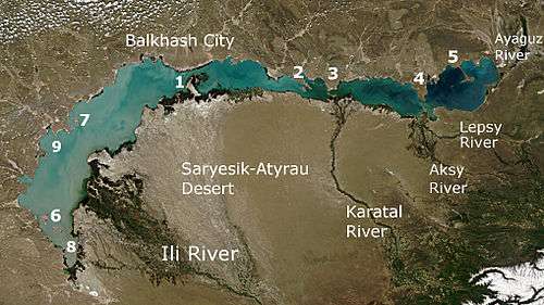
The numbers mark the largest peninsulas, island and bays:
|
Fauna
The Central Asiatic frog (Rana asiatica) is one of the amphibians found on the island.[5]
See also
References
- ↑ "Tasaral Aral". Mapcarta. Retrieved 27 May 2017.
- ↑ GoogleEarth
- ↑ Tim Cope, On the Trail of Genghis Khan: An Epic Journey Through the Land of the Nomads
- ↑ Karagandy. Karagandy Region Encyclopedia. Almaty: Atamura, 2006. ISBN 9965-34-515-5
- ↑ AmphibiaWeb - Rana asiatica, Central Asiatic Frog