Taranto
| Taranto | ||
|---|---|---|
| Comune | ||
| Comune di Taranto | ||
|
The 15th century Aragon Castle | ||
| ||
 Taranto Location of Taranto in Italy | ||
| Coordinates: 40°28′N 17°14′E / 40.467°N 17.233°ECoordinates: 40°28′N 17°14′E / 40.467°N 17.233°E | ||
| Country | Italy | |
| Region |
| |
| Province / Metropolitan city | Taranto (TA) | |
| Frazioni | Talsano, Lido Azzurro, Lama, San Vito, San Donato | |
| Area | ||
| • Total | 209.64 km2 (80.94 sq mi) | |
| Elevation | 15 m (49 ft) | |
| Population (April 2012) | ||
| • Total | 200,154 | |
| • Density | 950/km2 (2,500/sq mi) | |
| Demonym(s) | Tarantini or Tarentini | |
| Time zone | CET (UTC+1) | |
| • Summer (DST) | CEST (UTC+2) | |
| Postal code | 74121-74122-74123 | |
| Dialing code | (+39)099 | |
| Patron saint | Saint Catald of Taranto | |
| Saint day | May 10 | |
| Website | Official website | |
Taranto (Italian pronunciation: [ˈtaːranto]; early Italian: Tarento from Latin: Tarentum;[1] Ancient Greek: Τάρᾱς Tarās; Modern Greek: Τάραντας Tarantas; Tarantino "Tarde"[2]) is a coastal city in Apulia, Southern Italy. It is the capital of the Province of Taranto and is an important commercial port as well as the main Italian naval base.[3]
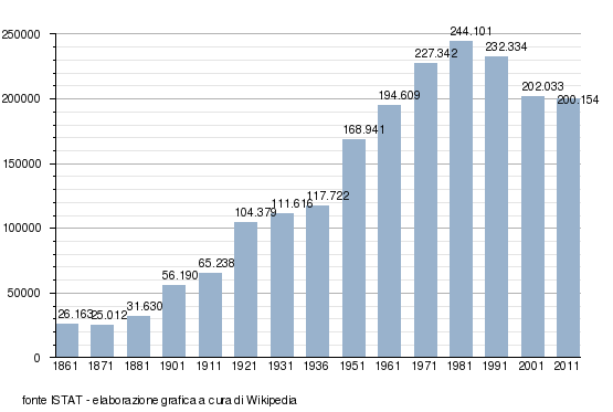
It is the third-largest continental city of Southern Italy: according to 2011 population census, it has a population of 200,154.
Taranto is an important commercial and military port. It has well-developed steel and iron foundries, oil refineries, chemical works, some shipyards for building warships, and food-processing factories.
In ancient times around 500 BC the city was one of the largest in the world with population estimates up to 300,000 people.[4][5]
Overview
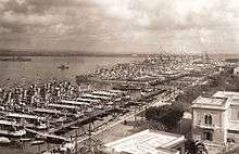
Taranto's pre-history dates back to 706 BC[6] when it was founded as a Greek colony, established by the Spartans. The ancient city was situated on a peninsula; the modern city has been built over the ancient Greek city of which only a few ruins remain, including part of the city wall, two temple columns dating to the 6th century BC, and tombs.[7]
The islets of S. Pietro and S. Paolo (St. Peter and St. Paul), collectively known as Cheradi Islands, protect the bay, called Mar Grande (Big Sea), where the commercial port is located. Another bay, called Mar Piccolo (Little Sea), is formed by the peninsula of the old city, and has flourishing fishing. Mar Piccolo is a military port with strategic importance.
At the end of the 19th century, a channel was excavated to allow military ships to enter the Mar Piccolo harbour, and the ancient Greek city become an island connected to the mainland by bridges. In addition, the islets and the coast are strongly fortified. Because of the presence of these two bays, Taranto is also called "the city of the two seas".
The Greek colonists from Sparta called the city Taras (Τάρας), after the mythical hero Taras, while the Romans, who connected the city to Rome with an extension of the Appian way, called it Tarentum.
.svg.png)
The natural harbor at Taranto made it a logical home port for the Italian naval fleet before and during the First World War. During World War II, Taranto became famous as a consequence of the November 1940 British air attack on the Regia Marina naval base stationed here, which today is called the Battle of Taranto.
Taranto is also the origin of the common name of the Tarantula spider family, Theraphosidae, even though strictly speaking there are no members of Theraphosidae in the area. In ancient times, residents of the town of Taranto, upon being bitten by the large local Wolf Spider, Lycosa tarentula, would promptly do a long vigorous dance like a Jig. This was done in order to sweat the venom out of their pores, even though the spider's venom was not fatal to humans. The frenetic dance became known as the Tarantella.
In geology, Taranto gives its name to the Tarantian Age of the Pleistocene Epoch.
Physical geography
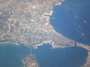
Taranto faces the Ionian Sea. It is 14.5 metres (48 ft) above sea level. It was built on a plain running north/north-west–southeast, and surrounded by the Murgia plateau from the north-west to the east. Its territory extends for 209.64 square kilometres (80.94 sq mi) and is mostly underwater. It is characterised by three natural peninsulas and a man-made island, formed by digging a ditch during the construction of Aragon Castle. The city is known as the "city of two seas" because it is washed by the Big Sea in the bay between Punta Rondinella to the northwest and Capo San Dante to the south, and by the vast reservoir of the Little Sea.
Big Sea and Little Sea
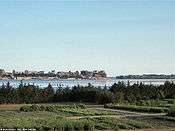
The Big Sea is frequently known as the Big Sea bay as that is where ships harbour. It is separated from the Little Sea by a cape which closes the gulf, leading to the artificial island. This island formed the heart of the original city and it is connected to the mainland by the Ponte di Porta Napoli and the Ponte Girevole. The Big Sea is separated from the Ionian Sea by the Capo San Vito, the Isole Cheradi of St Peter and St Paul, and the three islands of San Nicolicchio, which are completely incorporated by the steel plant. The latter form a little archipelago which closes off the arc creating the natural Big Sea bay.
The Little Sea is considered to be a lagoon so it presents problems of water exchange. It is virtually divided into two by the Ponte Punta Penna Pizzone, which joins the Punta Penna to the Punta Pizzone. The first of these forms a rough triangle, whose corners are the opening to the east and the Porta Napoli channel linking it to the Big Sea in the west. The second half forms an ellipse whose major axis measures almost 5 kilometres (3 miles) from the south-west to the north-east. The Galeso river flows into the first half.

The two seas have slightly different winds and tides and their underwater springs have different salinities. These affect the currents on the surface and in the depths of the Big Sea and the two halves of the Little Sea. In the Big Sea and in the northern part of the Little Sea, there are some underwater springs called citri,[8] which carry undrinkable freshwater together with salt water. This creates the ideal biological conditions for cultivating Mediterranean mussels, known locally as cozze.
Climate
The climate of the city, recorded by the weather station situated near the Grottaglie Military Airport, is typical of the Mediterranean with frequent Continental features.
The spring is usually mild and rainy, but it is not uncommon to have sudden cold spells come in from the east, which often cause snowfall.
The summer is very hot and humid, with temperatures reaching up to 40 °C (104 °F).
On 28 November 2012 a large F3 tornado hit the port of Taranto and damaged the Taranto Steel Mill where workers were protesting against the plant's pollution emissions; about 20 people were injured, and another man was reported missing. The tornado is one of nine to hit Italy since 1 October.
| Climate data for Taranto | |||||||||||||
|---|---|---|---|---|---|---|---|---|---|---|---|---|---|
| Month | Jan | Feb | Mar | Apr | May | Jun | Jul | Aug | Sep | Oct | Nov | Dec | Year |
| Record high °C (°F) | 20.0 (68) |
21.0 (69.8) |
28.0 (82.4) |
29.0 (84.2) |
34.0 (93.2) |
40.8 (105.4) |
43.0 (109.4) |
42.0 (107.6) |
39.0 (102.2) |
32.2 (90) |
26.4 (79.5) |
23.0 (73.4) |
43.0 (109.4) |
| Average high °C (°F) | 12.3 (54.1) |
12.8 (55) |
15.0 (59) |
17.8 (64) |
22.4 (72.3) |
26.7 (80.1) |
29.8 (85.6) |
29.6 (85.3) |
26.5 (79.7) |
21.8 (71.2) |
17.3 (63.1) |
13.6 (56.5) |
20.5 (68.9) |
| Daily mean °C (°F) | 9.1 (48.4) |
9.5 (49.1) |
11.4 (52.5) |
14.0 (57.2) |
18.2 (64.8) |
22.3 (72.1) |
25.1 (77.2) |
25.1 (77.2) |
22.2 (72) |
18.1 (64.6) |
13.8 (56.8) |
10.4 (50.7) |
16.6 (61.9) |
| Average low °C (°F) | 6.0 (42.8) |
6.2 (43.2) |
7.8 (46) |
10.2 (50.4) |
14.0 (57.2) |
18.0 (64.4) |
20.5 (68.9) |
20.7 (69.3) |
18.0 (64.4) |
14.4 (57.9) |
10.4 (50.7) |
7.2 (45) |
12.8 (55) |
| Record low °C (°F) | −10.0 (14) |
−5.0 (23) |
−6.4 (20.5) |
−2.4 (27.7) |
2.0 (35.6) |
7.4 (45.3) |
8.8 (47.8) |
10.2 (50.4) |
6.4 (43.5) |
1.0 (33.8) |
−3.0 (26.6) |
−4.8 (23.4) |
−10.0 (14) |
| Average precipitation mm (inches) | 45 (1.77) |
45 (1.77) |
42 (1.65) |
29 (1.14) |
22 (0.87) |
12 (0.47) |
11 (0.43) |
20 (0.79) |
23 (0.91) |
63 (2.48) |
52 (2.05) |
61 (2.4) |
425 (16.73) |
| Average precipitation days (≥ 1.0 mm) | 6 | 6 | 5 | 5 | 4 | 2 | 2 | 3 | 3 | 6 | 6 | 7 | 55 |
| Average relative humidity (%) | 78 | 75 | 73 | 71 | 68 | 63 | 61 | 63 | 66 | 73 | 77 | 80 | 70.7 |
| Mean monthly sunshine hours | 126 | 131 | 156 | 221 | 284 | 316 | 341 | 327 | 246 | 197 | 140 | 110 | 2,595 |
| Source #1: Archivio climatico Enea-Casaccia (temperature and precipitation),[9] Danish Meteorological Institute (sun, 1931–1960)[10] | |||||||||||||
| Source #2: Servizio Meteorologico (humidity, 1961–1990 and extremes 1943–present recorded at Taranto-Grottaglie Airport)[11][12] | |||||||||||||
It is classified as Geographical zone C and having a degree-day of 30.
History
Taranto was founded in 706 BC by Dorian Greek immigrants as the only Spartan colony,[6] and its origin is peculiar: the founders were Partheniae ("sons of virgins"), sons of unmarried Spartan women and Perioeci (free men, but not citizens of Sparta); these out-of-wedlock unions were permitted extraordinarily by the Spartans to increase the prospective number of soldiers (only the citizens of Sparta could become soldiers) during the bloody Messenian Wars, but later they were retroactively nullified, and the sons were then obliged to leave Greece forever. Phalanthus, the Parthenian leader, went to Delphi to consult the oracle: the puzzling answer designated the harbour of Taranto as the new home of the exiles. The Partheniae arrived in Apulia, and founded the city, naming it Taras after the son of the Greek sea god, Poseidon, and of a local nymph, Satyrion. According to other sources, Heracles founded the city. Another tradition indicates Taras as the founder of the city; the symbol of the Greek city (as well as of the modern city) depicts the legend of Taras being saved from a shipwreck by riding a dolphin that was sent to him by Poseidon. Taranto increased its power, becoming a commercial power and a sovereign city of Magna Graecia,[13] ruling over the Greek colonies in southern Italy.
Its independence and power came to an end as the Romans expanded throughout Italy. Taranto won the first of two wars against Rome for the control of Southern Italy: it was helped by Pyrrhus, king of Greek Epirus,[13] who surprised Rome with the use of war elephants in battle, a thing never seen before by the Romans. Rome won the second war in 272 BC. This subsequently cut off Taranto from the centre of Mediterranean trade, by connecting the Via Appia directly to the port of Brundisium (Brindisi).
Ancient art
Like many Greek city states, Taras issued its own coins in the 5th and 4th centuries BC. The denomination was a Nomos, a die-cast silver coin whose weight, size and purity were controlled by the state. The highly artistic coins presented the symbol of the city, Taras being saved by a dolphin, with the reverse side showing the likeness of a hippocamp, a horse-fish amalgam which is depicted in mythology as the beast that drew Poseidon's chariot.
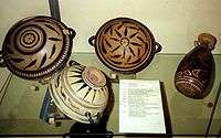
Taras was also the centre of a thriving decorated Greek pottery industry during the 4th century BC. Most of the South Italian Greek vessels known as Basilican ware were made in different workshops in the city.
Unfortunately, none of the names of the artists have survived, so modern scholars have been obliged to give the recognizable artistic hands and workshops nicknames based on the subject matter of their works, museums which possess the works, or individuals who have distinguished the works from others. Some of the most famous of the Apulian vase painters at Taras are now called: the Iliupersis Painter, the Lycurgus Painter, the Gioia del Colle Painter, the Darius Painter, the Underworld Painter, and the White Sakkos Painter, among others.
The wares produced by these workshops were usually large elaborate vessels intended for mortuary use. The forms produced included volute kraters, loutrophoroi, paterai, oinochoai, lekythoi, fish plates, etc. The decoration of these vessels was red figure (with figures reserved in red clay fabric, while the background was covered in a black gloss), with overpainting (sovradipinto) in white, pink, yellow, and maroon slips.
Often the style of the drawings is florid and frilly, as was already the fashion in 4th-century Athens. Distinctive South Italian features also begin to appear. Many figures are shown seated on rocks. Floral motifs become very ornate, including spiraling vines and leaves, roses, lilies, poppies, sprays of laurel, acanthus leaves, etc. Often the subject matter consists of naiskos scenes (scenes showing the statue of a deceased person in a naos, a miniature temple or shrine). Most often the naiskos scene occupies one side of the vase, while a mythological scene occupies the other. Images depicting many of the Greek myths are only known from South Italian vases, since Athenian ones seem to have had more limited repertoires of depiction.
|
Municipal bankruptcy
The Municipality of Taranto was declared bankrupt as of 31 December 2005, it had accrued liabilities in an amount equal to €637 million. This was one of the biggest financial crises which has ever hit a municipality.
The municipality was officially declared bankrupt on 18 October 2006 by the receiver Tommaso Blonda. He was appointed after the resignation of the mayor, Rossana Di Bello. This followed her sixteen months imprisonment for her conviction for abuse of office and documentary forgery in relation to investigations made on the contract for the management of the city incinerator given to the company Termomeccanica.
Transport
_opening_1.jpg)
Taranto railway station connects the city with Rome, Naples, Milan, Bologna, Bari, Reggio di Calabria and Brindisi.
The Ponte Girevole (swing bridge), built in 1887, runs across the navigable ship canal that joins Mar Piccolo (Little Sea) with Mar Grande (Big Sea) and stretches along 89.9 metres (295 ft). When the bridge is open, the two ends of the city are disconnected.
Environment
In 1991 Taranto was declared a high environmental risk area by the Ministry of Environment. As a consequence of the pollutants discharged into the air by the factories in the area, most notably the ILVA steel plant, part of Gruppo Riva, Taranto is the most polluted city in Italy and western Europe. 7% of Taranto's pollution is produced by the public; 93% is produced by factories. In 2005, the European Pollutant Emission Register estimated dioxin emissions from the Taranto ILVA plant were responsible for 83% of Italy's total reported emissions.[14] Every year the city is exposed to 2.7 tonnes (2.7 long tons; 3.0 short tons) of carbon monoxide and 57.7 tonnes (56.8 long tons; 63.6 short tons) of carbon dioxide. In 2014, the Italian National Institute of Emissions and their Sources,[15] state that Taranto stands third in the world behind China's Linfen, and Copşa Mică in Romania, the most polluted cities in the world due to factories' emissions.
In particular, the city produces ninety-two percent of Italy's dioxin. This is 8.8 percent of the dioxin in Europe. Between 1995 and 2004, leukaemias, myelomas and lymphomas increased by 30 to 40 percent. Dioxin accumulates over the years. Over 9 kilos of dioxin have been discharged into the city's air by its factories.
Grazing is banned within 20 kilometres (12 mi) of the ILVA plant.[16]
In 2013, the Riva family, owner of the ILVA plant, is being tried for ecological disaster. Emissions of both carbon monoxide, carbon dioxide and dioxin have decreased. Animal species have returned that had left, including swallows, cranes, dolphins, seahorses and the coral reef.
Architecture and landmarks
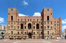
Taranto has a number of sites of historic value. Situated at the angle of the canal, Big Sea and Piazza Castello, the Aragon Castle was built between 1486 and 1492 by orders of King Ferdinand II of Aragon for the purpose of protecting the city from the Turks' frequent raids.[17] The castle which was designed by Italian painter and architect Francesco di Giorgio Martini replaced a pre-existing 9th century Byzantine fortress which was deemed unfit for 15th century warfare.[17][18] In 1707 it ceased to be used as a military fortress and was converted to a prison until under Napoleon Bonaparte it reverted to its original military function. To date it is the property of the Italian Navy and is open to the public. Twenty-first century excavations revealed the castle's earlier Byzantine foundations which can be viewed.[17]
There are several Greek temple ruins - some from the 6th century BC - such as the remains of a temple dediccated to Poseidon with its two surviving Doric columns still visible on Piazza Castello in the Citta Vecchia.[7]
The Promenade (lungomare), named after former Italian king Victor Emmanuel III, overlooks the Mar Grande, the natural harbour and commercial port.
Old Town
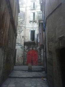
The Old Town or Città Vecchia is where the Greeks built their acropolis. To date it has the same lay out as it did in 967, when the Byzantines under Nicephorus Phocas rebuilt what the Saracen troops led by the Slavic Sabir had razed to the ground in 927 AD.[19] There are four main arteries (Corso Vittorio II, Via Duomo, Via di Mezzo and Via Garibaldi) which run in a straight direction however the side streets were purposely built narrow and winding to impede the passage of an invading army.[20] Incorporating the Aragon Castle, Doric Columns and Piazza Fontana, it is situated and entirely enclosed on the artificial island between the Big and Little Seas and is reached from the New Town by crossing the Ponte Girevole from the south and the Ponte di Porta Napoli from the north. Almost rectangular in shape, it is divided into four ''pittaggi'' ( quarters) that are delineated by the cross formed between Via di Mezzo and postiliera Via Nuova. These are "Baglio" and "San Pietro" in the upper section which face the Big Sea; and "Turipenne" and "Ponte" in the lower part fronting the Little Sea.[19] The nobility, clergy and military personnel made their homes in Baglio and San Pietro, whilst the artisans and fishermen dwelled in Ponte and Turipenne. An Armenian community was present in the 10th and 11th centuries having arrived in Taranto as troops in the Byzantine Army. The San't Andrea degli Armeni church in Piazza Monteoliveto, located in the Baglio quarter, stands as testimony to the neighbourhood where the Armenians made their homes.[21] In 1746 the entire population of Taranto resided in Old Town. This resulted in the necessity of building additional stories on the narrow houses.[22] It is still inhabited with a number of people living in juxtaposition to the old palazzi. The population as of 2013 was 1000.[19]
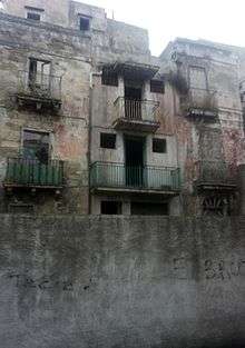
There are a number of 17th and 18th-century palazzi in Old Town. For years, they served as the main residence of local aristocratic families and the clergy. These include Palazzo Calò, Palazzo Carducci-Artenisio (1650), Palazzo Galeota (1728), Palazzo Gallo (17th century), Palazzo Latagliata, Palazzo Lo Jucco (1793) and Palazzo Pantaleo. The 17th century de Beaumont-Bonelli-Bellacicco palace houses the Spartan Museum of Taranto - Hypogeum Bellacicco which extends below street and sea level to the hypogeum that is a crossroads with other hypogeum of Old Town which together form the system of subterranean Taranto.[18]
Churches include the San Cataldo Cathedral (10th century) in Piazza Duomo, San Domenico Maggiore (1302), Sant'Andrea degli Armeni (16th century), San Agostino (1402), San Michele (1763), the Madonna della Salute sanctuary (1752), and San Giuseppe (16th century).[18] Close to the San Agostino church, located near Pendio La Riccia, the buried remains of an ancient Greek temple were discovered.
Beginning in 1934 Benito Mussolini embarked on a project of rejuvenation that involved the demolition of the working class Turipenne pittaggio along the Via Garibaldi and ''Discesa Vasto'' which contained the homes of local fishermen as well as the old Jewish quarter. The demolitions, which also razed the old medieval wall and three churches out of the four within the area, continued until the outbreak of World War II. Modern edifices and apartment blocks were erected to replace the demolished structures.[23]
In addition to the many palazzi, Old Town has myriad arched alleyways, saliti, vicoli and small streets, some of which are closed to traffic. Between 2013 and 2014 two Neapolitan urban artists Cyop and Kaf embarked on a project to decorate derelict buildings, walls and doors in the piazzi and vicoli with 120 representations of street art. It has since become a striking feature of Old Town which is described as the abandoned district of Taranto.[24]
Education
Among the various school are : Liceo Scientifico Battaglini, IIS Archita, IIS Quinto Ennio (in Literature), IIS Aristosseno (Languages), Galileo Ferraris, ITCS Pitagora da Taranto, Vittorino da Feltre, ITIS Righi and ITIS Pacinotti (in IT) and ITC V. Bachelet (in Commercial and Accounting – famous for the activities at BIT MILANO).
Demographics
Census populations
Dialect

The city is the centre of the Tarantino dialect (Dialètte tarandine) of the Neapolitan language. As a result of the city's history, it is influenced by Greek, Vulgar Latin and French.
Film
MaldiMare Film 2014
Sports
- Taranto F.C. 1927 (soccer)
Twin towns
Taranto is twinned with:
 Sparta, Greece, since 24 July 2015 [25]
 Brest, France; since 1964.[26]
 Donetsk, Ukraine; a sister city since 1985.[27]
 Alicante, Spain; since 2010.
 Islamabad, Pakistan; since 2010.
Notable people
These historical figures have had a relationship with the city. Not all of them were actually born in Taranto.
- Archytas of Tarentum, philosopher, mathematician, astronomer, statesman, strategist and commander-in-chief of the army of Taranto
- Philolaus, mathematician and philosopher
- Aristoxenus, peripatetic philosopher, and writer on music and rhythm
- Leonidas of Tarentum, poet
- Lysis of Tarentum, philosopher
- Cleinias of Tarentum, Pythagorean philosopher
- Rhinthon (c. 323–285 BC), dramatist
- Zeuxis (3rd century BCE), physician
- Livius Andronicus, poet
- Titus Quinctius Flamininus, propraetor of Tarentum
- Pacuvius, tragic poet, died in Tarentum in 130 BC
- Cataldus, archbishop and patron saint of Taranto
- Bohemond of Taranto, (born in Calabria)[28][29] key military leader on the First Crusade
- Philip I, Prince of Taranto, Latin Emperor in exile 1313–1332 (as Philip II), king of Albania
- Gil Albornoz, archbishop of Taranto in 1644
- Giovanni Paisiello, composer
- Pierre Choderlos de Laclos, Napoleonic army general and novelist, died in Taranto
- Etienne-Jacques-Joseph-Alexandre MacDonald (1765–1840), duke of Taranto and marshal of France
- Marcus Fulvius Nobilior, rumoured to have been born here and not Rome as was first assumed
- Riccardo Tisci, fashion designer, creative director of Givenchy
- Roberta Vinci, professional tennis player
- Cosimo Damiano Lanza, pianist, harpsichordist and composer
- Pino De Vittorio, singer, actor
- Quentin Tarantino, whose family derives its surname from its origins in the city
- Michele Riondino, actor, director, singer[30]
- Laura Albanese, Italian-Canadian newscaster and politician
- Nicola Martinucci, cantante lirico - tenore
See also
References
- Notes
- ↑ Eric Partridge, Origins: a short etymological dictionary of modern English, p. 695
- ↑ Gigante, Nicola (2002). Dizionario dell parlata Tarantina. Mandese editore. p.850
- ↑ "Port of Taranto". World Port Source. Retrieved 2011-09-16.
- ↑ Oppenheimer, Michael (1 January 2002). "The Monuments of Italy: A Regional Survey of Art, Architecture and Archaeology from Classical to Modern Times". Tauris. Retrieved 26 December 2016 – via Google Books.
- ↑ Halsey, William Darrach; Friedman, Emanuel (1 January 1986). "Collier's Encyclopedia, with Bibliography and Index". Macmillan Educational Company. Retrieved 26 December 2016 – via Google Books.
- 1 2 "Taranto History, Italy". Travelgrove.com. Retrieved 2012-01-17.
- 1 2 "Taranto Tourism and History". Taranto.eu. 2004-01-01. Retrieved 2012-01-17.
- ↑ Parenzan, Pietro (1972). "L'anello di san Cataldo nel Mar Grande di Taranto" (PDF). Thalassia Salentina. 6: 3–24. Retrieved 2009-05-07.
- ↑ "Profilo climatico dell'Italia: Taranto" (in Italian). Ente per la Nuove tecnologie, l'Energia e l'Ambiente. Retrieved January 5, 2015.
- ↑ Cappelen, John; Jensen, Jens. "Italien - Taranto" (PDF). Climate Data for Selected Stations (1931-1960) (in Danish). Danish Meteorological Institute. p. 147. Archived from the original (PDF) on April 27, 2013. Retrieved April 7, 2017.
- ↑ "STAZIONE 324 GROTTAGLIE: medie mensili periodo 61 - 90". Servizio Meteorologico. Retrieved January 5, 2015.
- ↑ "Taranto Grottaglie: Record mensili dal 1943" (in Italian). Servizio Meteorologico dell’Aeronautica Militare. Retrieved January 5, 2015.
- 1 2 "History of Taranto". Italythisway.com. Retrieved 2011-09-16.
- ↑ "Answer given by Mr Dimas on behalf of the Commission". Parliamentary Questions. European Parliament. 28 November 2007. Retrieved 11 August 2011.
- ↑ Inventario nazionale delle emissioni e loro sorgenti (INES)
- ↑ "Italian town fighting for its life over polluting Ilva steelworks". 18 August 2012.
- 1 2 3 http://www.viaggareinpuglia.it/at/1/castellotorre/96/en/Taranto-Aragon--Castle
- 1 2 3 "Palazzi e vari a Taranto". 7 April 2014. Retrieved 26 December 2016.
- 1 2 3 "The Old Town of Taranto: Architectural Reading of the History Urban Form for the Correct Methodology for Restoration Project the Built Heritage in the Island". Ubaldo Occhinegro. Polytecnic School of Bari. Paper Number 362-8. Proceeding of the 2nd ICAUD International Conference on Architecture and Urban Design. Epoka University, Tirana, Albania 8–10 May 2014. Paper No. 362
- ↑ Taranto - 1911 Encyclopædia Britannica
- ↑ "S.Andrea degli Armeni". 6 February 2014. Retrieved 26 December 2016.
- ↑ "Taranto Città Vecchia: Storia e Foto dell'isola - Taranto Magna". Retrieved 26 December 2016.
- ↑ Taranto, Archeologia, Storia, Architettura"
- ↑ "Street Art; un anno in Città Vecchia". Corriere di Taranto. Gaetano De Monte. 27 October 2015
- ↑ "Day of Twin between Taranto and Sparta". 24 Jul 2015. Retrieved 30 July 2015.
- ↑ "Taranto twinned with Brest". 23 Jul 2009. Retrieved 18 March 2012.
- ↑ "Twin Cities and city-partners in Donetsk". Retrieved 18 March 2012.
- ↑ "Antioch History". Nobledynasty.com. Retrieved 2013-03-12.
- ↑ "Bohemond I. of Antioch b. Abt. 1058 San Marco Argentano in Calabria d. 1111: Skeel and Kannegaard Genealogy". Skeel.info. Retrieved 2013-03-12.
- ↑ "Michele Riondino". IMDb. Retrieved 2013-10-06.
External links
| Look up taranto in Wiktionary, the free dictionary. |
| Wikimedia Commons has media related to Taranto. |
- Official website
- Taranto Jewish History
- Culture Centre Filonide
- Tourism in Taranto
- Holy Week Rites in Taranto, Italy (website in English and Spanish)
- MARTA: Museo nazionale ARcheologico TAranto (Taranto Archaeological National Museum)
- Word of the Day: Tarantula and Tarantella, From Taranto, etymology and folklore


