Tapti River
| Tapti (Tapi) तपती, ताप्ती, तापी, તાપ્તી | |
| Surya Putri सुर्यपुत्री, સુર્યપુત્રી | |
| River | |
| Country | |
|---|---|
| States | Madhya Pradesh, Maharashtra, Gujarat |
| Cities | Multai, Betul, Burhanpur, Bhusawal, Surat |
| Source | |
| - location | Betul District |
| Mouth | Gulf of Khambhat (Arabian Sea) |
| - location | Dumas, Surat, Gujarat |
| Length | 724 km (450 mi) approx. |
| Discharge | for Dumas Beach |
| - average | 489 m3/s (17,269 cu ft/s) [1] |
| - max | 9,830 m3/s (347,143 cu ft/s) |
| - min | 2 m3/s (71 cu ft/s) |
The Tapi River (or Taptee)[2] flows in central India from east to west, between the Godavari and Narmada rivers.[3] It flows through Surat, and is crossed by the Magdalla ONGC Bridge.[4]
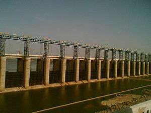
Prakasha Barage on Tapti River, at Prakasha
Etymology
The river is supposedly named after the goddess Tapti, the daughter of Surya, the Sun god, who according to legend founded the Kuru Dynasty when she married King Samvarna.[5]
| Wikisource has original text related to this article: |
See also
References
- ↑ "Tapti Basin Station: Kathore". UNH/GRDC. Retrieved 2013-10-01.
- ↑ Herne, P. (1855). "XXIII: Domus. Surat. The nature of the jungles beyond. A boa constrictor. A tiger. A lion. Terrible conflict. A Banyan tree.". Perils and Pleasures of a Hunter's Life; or the Romance of Hunting by Peregrine Herne (PDF). Cornell University Library. p. 194–204. Retrieved 2017-07-08.
- ↑ "Tapi River / Tapti River". mapsofindia.com. Retrieved 29 July 2016.
- ↑ "Truck falls into Tapi River from Magdalla Bridge, driver missing". The Times of India. Bennett, Coleman & Co. 31 May 2016. Retrieved 12 June 2016.
- ↑ Mittal, J.P. (2006). History of ancient India : a new version. New Delhi: Atlantic. p. 412. ISBN 9788126906161. Retrieved 21 July 2016.
Coordinates: 21°06′N 72°41′E / 21.100°N 72.683°E
This article is issued from
Wikipedia.
The text is licensed under Creative Commons - Attribution - Sharealike.
Additional terms may apply for the media files.