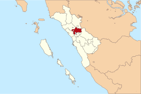
Tanah Datar Regency
| Tanah Datar تانه داتار | ||
|---|---|---|
| Regency | ||
| ||
 | ||
| Country | Indonesia | |
| Province | West Sumatra | |
| Capital | Batusangkar | |
| Area | ||
| • Total | 1,336.60 km2 (516.06 sq mi) | |
| Population (2014) | ||
| • Total | 356,085 | |
| • Density | 270/km2 (690/sq mi) | |
| Time zone | WIB (UTC+7) | |
| Area code(s) | +62 752 | |
| Website | www.tanahdatar.go.id | |


Tanah Datar is a regency (kabupaten) in West Sumatra province, Indonesia. The regency has a population of 338,584 at the 2010 Census, which according to official estimates had risen to 356,085 in January 2014. The capital of the regency is Batusangkar. The town of Padang Panjang is also geographically located within the regency but constitutes a municipality (kota otonom) of its own.
Tanah Datar has several tourist attractions including the Pagaruyung Palace (Istano Pagaruyuang) with its museum, Sanskrit and Malay language stone inscriptions from the 14th century, several sites with megaliths (batu tagak), and the village Pandai Sikat (Pandai Sikek), where the traditional songket (kain balapak) is still woven. The northern part of Lake Singkarak is also situated in Tanah Datar.
Administration
Tanah Datar is divided into fourteen districts (kecamatan), listed below with their populations at the 2010 Census:
- Sepuluk Koto (42,133)
- Batipuh (29,896)
- Batipuh Selatan (10,430)
- Pariangan (19,519)
- Rambatan (33,287)
- Lima Kaum (35,784)
- Tanjung Emas (21,689)
- Padang Ganting (13,641)
- Lintau Buo (17,564)
- Lintau Buo Utara (34,810)
- Sungayang (16,903)
- Sungai Tarab (29,282)
- Salimpaung (20,768)
- Tanjung Baru (12,788)
External links
- (in Indonesian) Official website
Coordinates: 0°27′00″S 100°34′59″E / 0.45°S 100.583°E

