Tórshavn Municipality
| Tórshavn Municipality Tórshavnar kommuna | |
|---|---|
 | |
| Coordinates: 62°02′N 6°53′W / 62.04°N 6.88°WCoordinates: 62°02′N 6°53′W / 62.04°N 6.88°W | |
| State |
|
| Constituent country |
|
| Islands |
Streymoy Koltur Hestur Nólsoy |
| Area | |
| • Total | 173 km2 (67 sq mi) |
| Population (2017) | |
| • Total | 20,885 |
| • Density | 121/km2 (310/sq mi) |
| Website |
torshavn |
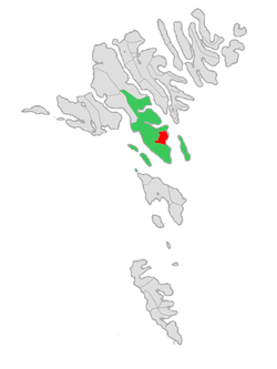
Tórshavn Municipality[1] (Tórshavnar kommuna) is the municipality of the Faroese capital Tórshavn and its surroundings.
The municipality covers the southern half of Streymoy island and adjacent minor islands and has an area of 173 km2. It became an independent municipality in 1866 and is the largest in the Faroes. The municipality has a population of about 20,600 (May 2016) or 41.8% of the total population of the islands.[2]
It contains the following towns and villages:
- Tórshavn
- Argir
- Hoyvík
- Hvítanes
- Kaldbak
- Kaldbaksbotnur
- Kirkjubøur
- Velbastaður
- Kollafjørður
- Oyrareingir
- Signabøur
- Sund
- Norðradalur
- Syðradalur
- Nólsoy
- Hestur
- Koltur
Population progression
Progression of the population of Tórshavn since 1801:
| Year | 1801 | 1854 | 1900 | 1925 | 1950 | 1975 | 1980 | 1985 | 1990 | 1995 | 1997 | 1998 | 1999 | 2000 | 2001 | 2002 | 2005 | 2007 | 2015 | 2017 |
|---|---|---|---|---|---|---|---|---|---|---|---|---|---|---|---|---|---|---|---|---|
| Population | 554 | 900 | 1,656 | 2,896 | 5,607 | 11,329 | 12,641 | 16,118 | 17,703 | 16,500 | 16,925 | 17,253 | 17,498 | 17,890 | 18,245 | 18,570 | 19,282 | 19,318 | 20,198 | 20,885 |
References
Sources
External links
This article is issued from
Wikipedia.
The text is licensed under Creative Commons - Attribution - Sharealike.
Additional terms may apply for the media files.
