Suvo Rudište
| Suvo Rudište | |
|---|---|
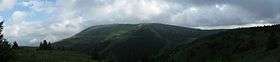 Pančić's Peak (left) and Suvo Rudište Peak (right), highest peaks on Kopaonik. | |
| Highest point | |
| Elevation | 1,976 m (6,483 ft) |
| Coordinates | 43°16′18″N 20°49′04″E / 43.2715803°N 20.8178176°ECoordinates: 43°16′18″N 20°49′04″E / 43.2715803°N 20.8178176°E |
| Geography | |
 Suvo Rudište Location in Serbia | |
| Location | Serbia |
| Parent range | Kopaonik |
Suvo Rudište (Serbian Cyrillic: Суво Рудиште) is the name of a mountain plateau and its peak at 1976 m, belonging to the Kopaonik mountain (and Kopaonik mountain range) in Serbia.
The locale of Suvo Rudište (a touristical settlement), in Kopaonik, Raška, is a center of the Kopaonik National Park. The area is a natural reservation, covering 50,63 hectares, located on the northeastern slopes of the Suvo Rudište Peak, on part of the slopes stretching from Pančić's Peak towards the source prong of Brzećka reka including the locale of Krčmar voda.
The area was studied by botanist Josif Pančić (1814–1888).
It was a site of operations in World War II.[1]
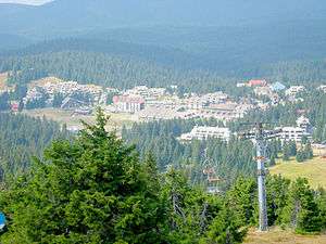
Hotels in the Kopaonik tourist centre, view from the slopes of Suvo Rudište.
References
- ↑ Petar M. Višnjić (1984). Bitka za Srbiju. Beogradska knjiga. pp. 88–90.
Further reading
- Republički zavod za zaštitu prirode (1989). Zaštita prirode [Protection of nature]. 41–45. Naučna knjiga. p. 40.
- Commission for the Geological Map of the World. Sub-commission for the Metallogenic Map of the World (1977). The Iron ore deposits of Europe and adjacent areas. Bundesanst. für Geowiss. u. Rohstoffe. pp. 413–.
External links
| Wikimedia Commons has media related to Suvo Rudište. |
- "Suvo Rudište". Nacionalni park Kopaonik.
- "План детаљне регулације Суво Рудиште". ekoregistar.
- "National Park Kopaonik".
This article is issued from
Wikipedia.
The text is licensed under Creative Commons - Attribution - Sharealike.
Additional terms may apply for the media files.