Sudipen
| Sudipen | ||
|---|---|---|
| Municipality | ||
| Municipality of Sudipen | ||
|
Sudipen town center | ||
| ||
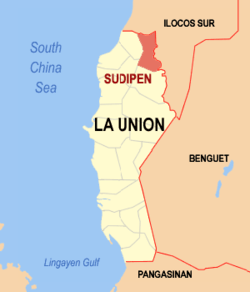
 Map of La Union with Sudipen highlighted | ||
.svg.png) Sudipen Location within the Philippines | ||
| Coordinates: 16°54′N 120°28′E / 16.9°N 120.47°ECoordinates: 16°54′N 120°28′E / 16.9°N 120.47°E | ||
| Country |
| |
| Region | Ilocos Region (Region I) | |
| Province | La Union | |
| District | 1st district of La Union | |
| Barangays | 17 (see Barangays) | |
| Government [1] | ||
| • Type | Sangguniang Bayan | |
| • Mayor | Wendy Joy D. Buquing | |
| • Electorate | 11,994 voters (2016) | |
| Area [2] | ||
| • Total | 97.59 km2 (37.68 sq mi) | |
| Population (2015 census)[3] | ||
| • Total | 17,056 | |
| • Density | 170/km2 (450/sq mi) | |
| Time zone | PST (UTC+8) | |
| ZIP code | 2520 | |
| PSGC | 013319000 | |
| IDD : area code | +63 (0)72 | |
| Climate type | tropical monsoon climate | |
| Income class | 4th municipal income class | |
| Website |
www | |
Sudipen (Southern Ilocano pronunciation: [sudipɯn]), officially the Municipality of Sudipen, is a 4th class municipality in the province of La Union, Philippines. According to the 2015 census, it has a population of 17,056 people.[3]
Geography
Sudipen is located 312 kilometres (194 mi) north-north-west of the Philippine capital, Manila, and 43 kilometres (27 mi) away from the provincial capital of San Fernando, La Union. It is bounded on the west by the municipalities of Bangar and Balaoan; on the east and north by the Amburayan River and the province of Ilocos Sur; and in the south by Santol.
Sudipen has a total land area of 97 square kilometers, making it the fifth largest municipality by land area in the province. [2] Barangay Bulalaan is the largest barangay with a land area of 8,988 hectares (22,210 acres), while Barangay Poblacion is the smallest with only 82 hectares (200 acres).
Barangays
Sudipen is politically subdivided into 17 barangays. [2]
- Bigbiga
- Bulalaan
- Castro
- Duplas
- Ilocano
- Ipet
- Maliclico
- Namaltugan
- Old Central ('Nagpanaoan)
- Poblacion
- Porporiket
- San Francisco Norte
- San Francisco Sur
- San Jose
- Sengngat
- Turod
- Up-uplas
Demographics
| Population census of Sudipen | ||
|---|---|---|
| Year | Pop. | ±% p.a. |
| 1918 | 3,569 | — |
| 1939 | 6,039 | +2.54% |
| 1948 | 6,922 | +1.53% |
| 1960 | 7,926 | +1.13% |
| 1970 | 9,785 | +2.13% |
| 1975 | 10,430 | +1.29% |
| 1980 | 10,796 | +0.69% |
| 1990 | 13,043 | +1.91% |
| 1995 | 14,075 | +1.44% |
| 2000 | 15,099 | +1.52% |
| 2007 | 15,949 | +0.76% |
| 2010 | 16,531 | +1.31% |
| 2015 | 17,056 | +0.60% |
| Source: Philippine Statistics Authority[3][4][5][6] | ||
In the 2015 census, the population of Sudipen was 17,056 people,[3] with a density of 170 inhabitants per square kilometre or 440 inhabitants per square mile.
Local government
- Mayor: Alexander "Alan" O. Buquing (Elected in the May 10, 2016 Elections)
- Vice Mayor: Edwin Belisoa
- Sangguniang Bayan:
- Wendy Joy D. Buquing
- Jhobet Dee
- Thelma Pena
- Mandy Adviento
- Tita Mostoles
- Donnie Rey Piaoan
- Melvin Macsui
- Lina Pang-ot
Liga ng mga Barangay: Edwin Oribio
Gallery
- Municipal hall
- Town center
- Sudipen Farmers Public Market
- Sudipen Central School
- Sudipen terminal
References
- ↑ "Municipality". Quezon City, Philippines: Department of the Interior and Local Government. Retrieved 31 May 2013.
- 1 2 3 "Province: La Union". PSGC Interactive. Quezon City, Philippines: Philippine Statistics Authority. Retrieved 12 November 2016.
- 1 2 3 4 Census of Population (2015). "Region I (Ilocos Region)". Total Population by Province, City, Municipality and Barangay. PSA. Retrieved 20 June 2016.
- ↑ Census of Population and Housing (2010). "Region I (Ilocos Region)". Total Population by Province, City, Municipality and Barangay. NSO. Retrieved 29 June 2016.
- ↑ Census of Population (1995, 2000 and 2007). "Region I (Ilocos Region)". Total Population by Province, City and Municipality. NSO. Archived from the original on 24 June 2011.
- ↑ "Province of La Union". Municipality Population Data. Local Water Utilities Administration Research Division. Retrieved 17 December 2016.
External links
| Wikimedia Commons has media related to Sudipen. |
- Philippine Standard Geographic Code
- Philippine Census Information
- Local Governance Performance Management System

