Storfosna
|
View of the island (looking north) | |
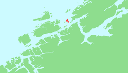
 Location in Sør-Trøndelag | |
| Geography | |
|---|---|
| Location | Sør-Trøndelag, Norway |
| Coordinates | 63°40′04″N 9°24′25″E / 63.6678°N 9.4070°ECoordinates: 63°40′04″N 9°24′25″E / 63.6678°N 9.4070°E |
| Area | 11 km2 (4.2 sq mi) |
| Length | 6 km (3.7 mi) |
| Width | 3 km (1.9 mi) |
| Highest elevation | 158 m (518 ft) |
| Highest point | Fosenfjellet |
| Administration | |
| County | Sør-Trøndelag |
| Municipality | Ørland |
Storfosna is a populated island in the municipality of Ørland in Sør-Trøndelag county, Norway. It is located between Kråkvåg and Garten at the mouth of the Trondheimsfjord. The traditional district of Fosen is named after this island. There is a large deer population on the island.[1]
The island is connected to Kråkvåg by a causeway and bridge, and is connected to Garten (and the mainland) by a car ferry. The Storfosna Church is located on the island.
References
- ↑ Store norske leksikon. "Storfosna" (in Norwegian). Retrieved 2011-01-12.
This article is issued from
Wikipedia.
The text is licensed under Creative Commons - Attribution - Sharealike.
Additional terms may apply for the media files.