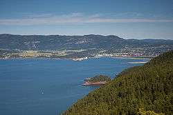
Stjørdalshalsen
| Stjørdalshalsen Stjørdal | |
|---|---|
| Town | |
|
View of the town | |
 Stjørdalshalsen Location in Nord-Trøndelag | |
| Coordinates: 63°28′04″N 10°55′03″E / 63.46778°N 10.91750°ECoordinates: 63°28′04″N 10°55′03″E / 63.46778°N 10.91750°E | |
| Country | Norway |
| Region | Trøndelag |
| County | Nord-Trøndelag |
| District | Stjørdalen |
| Municipality | Stjørdal |
| Area[1] | |
| • Total | 6.05 km2 (2.34 sq mi) |
| Elevation[2] | 7 m (23 ft) |
| Population (2013)[1] | |
| • Total | 11,139 |
| • Density | 1,841/km2 (4,770/sq mi) |
| Time zone | CET (UTC+01:00) |
| • Summer (DST) | CEST (UTC+02:00) |
| Post Code | 7500 Stjørdal |
Stjørdalshalsen (also known as Stjørdal or Halsen) is a town and the administrative centre of the municipality of Stjørdal in Nord-Trøndelag county, Norway. It is located between the rivers Stjørdalselva and Gråelva, and their mouth into the Trondheimsfjord.
Kjøpmannsgata is the main shopping street in Stjørdalshalsen
The 6.05-square-kilometre (1,490-acre) town has a population (2013) of 11,139. The population density of the town is 1,841 inhabitants per square kilometre (4,770/sq mi).[1] Stjørdalshalsen was granted town status in 1997. The Nordland Line runs through the town, which is served by Stjørdal Station. The junction of the European route E14 and European route E6 highways is in Stjørdalshalsen, just north of Trondheim Airport, Værnes.
References
- 1 2 3 Statistisk sentralbyrå (1 January 2013). "Urban settlements. Population and area, by municipality.".
- ↑ "Stjørdal" (in Norwegian). yr.no. Retrieved 2011-05-17.
This article is issued from
Wikipedia.
The text is licensed under Creative Commons - Attribution - Sharealike.
Additional terms may apply for the media files.

