Maine State Route 3
| ||||
|---|---|---|---|---|
 | ||||
| Route information | ||||
| Maintained by MaineDOT | ||||
| Length: | 119.21 mi[1] (191.85 km) | |||
| Major junctions | ||||
| West end: |
| |||
|
| ||||
| East end: |
| |||
| Highway system | ||||
| ||||

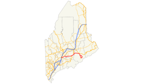
State Route 3 is part of Maine's system of numbered state highways, running from Route 8, 11 and 27 in Augusta to an intersection with Route 102 in the village of Somesville in the town of Mount Desert, on Mount Desert Island. Route 3 is 119.3 miles (192.0 km) in length.
Route 3 uses the Augusta Bypass, a controlled-access road completed in 2004 to alleviate congestion in the city center caused by traffic headed for Interstate 95. (Previous to this, Route 3 followed U.S. Route 202 into Augusta). It was extended in 2013 to reach Route 8, 11 and 27 just beyond the connection to I-95 and serve the new Alfond Center for Health and Cancer Center.[2] The bypass ends at U.S. Route 202 on the east end of Augusta, and Route 3 runs concurrently with U.S. 202 (the Belfast Road) to the village of South China, where U.S. 202 leaves to the north. Route 3 continues east to the city of Belfast, where it intersects U.S. 1.
U.S. 1 and Route 3 run concurrently from Belfast through Bucksport, crossing the Penobscot Narrows Bridge over the Penobscot River. From Bucksport, Route 3 and U.S. 1 continue along the Acadia Highway to the city of Ellsworth.
Route 3 leaves U.S. 1 at The Triangle, an intersection at the south end of Ellsworth that has been the center of numerous traffic problems within that city . Continuing south through Trenton, the route crosses a causeway to Mount Desert Island. Route 3 follows the island's eastern shore to the tourist town of Bar Harbor, then continues south through Acadia National Park to the village of Northeast Harbor. The route then turns north, running along with Route 198 to its end near the village of Somesville. Route 3 signs on this last portion of the Route lack directional indicators, as it almost forms a complete loop around the Eastern portion of Mount Desert Island. Signs state "Route" in replacement of directional signs. Directional signs start appearing just east of Seal Harbor when the highway starts turning North, though it is signed as East/West in keeping with the majority of the route.
Junction list
| County | Location[3] | mi[3] | km | Destinations | Notes |
|---|---|---|---|---|---|
| Kennebec | Augusta | 0.00 | 0.00 | ||
| 1.11– 1.48 | 1.79– 2.38 | Exit 113 on I-95 | |||
| 2.21 | 3.56 | ||||
| 3.25 | 5.23 | ||||
| 4.13 | 6.65 | Western end of concurrency with US 202 / SR 9 | |||
| China | 13.34 | 21.47 | Western end of concurrency with SR 32 | ||
| 14.60 | 23.50 | Eastern end of concurrency with SR 32 | |||
| 14.82 | 23.85 | Eastern end of concurrency with US 202 / SR 9 | |||
| Waldo | Liberty | 29.84 | 48.02 | ||
| Belmont | 40.05– 40.13 | 64.45– 64.58 | Brief concurrency with SR 131 | ||
| Belfast | 46.41 | 74.69 | Western end of concurrency with US 1 | ||
| 46.60– 46.91 | 75.00– 75.49 | Interchange; westbound exit and eastbound entrance via High Street; southern terminus of SR 7 / SR 137 | |||
| 47.12 | 75.83 | Passagassawakeag River | |||
| 47.40 | 76.28 | Southern terminus of SR 141 | |||
| Stockton Springs | 56.83 | 91.46 | Southern terminus of US 1A | ||
| Prospect | 62.94 | 101.29 | Eastern terminus of SR 174 | ||
| Waldo–Hancock county line | Prospect–Verona Island line | 63.13 | 101.60 | Penobscot Narrows Bridge over the Penobscot River | |
| Hancock | Bucksport | 64.51 | 103.82 | Western end of concurrency with SR 15 | |
| Orland | 65.66 | 105.67 | Southern terminus of SR 46 | ||
| 66.28 | 106.67 | Northern terminus of SR 175 | |||
| 68.91 | 110.90 | Eastern edn of concurrency with SR 15 | |||
| 73.09 | 117.63 | Eastern terminus of SR 176 | |||
| Ellsworth | 83.45 | 134.30 | |||
| 83.65 | 134.62 | Northern terminus of SR 230 | |||
| 83.93 | 135.07 | Northern terminus of US 1A | |||
| 84.96 | 136.73 | Eastern end of concurrency with US 1 | |||
| Trenton | 88.48 | 142.39 | Western terminus of SR 204 | ||
| 92.14 | 148.28 | Southern terminus of SR 230 | |||
| Bar Harbor | 93.51 | 150.49 | Northern terminus of SR 102 / SR 198 | ||
| 103.44 | 166.47 | Eastern terminus of SR 233 | |||
| Mount Desert | 115.04 | 185.14 | Western end of concurrency with SR 198 | ||
| 119.31 | 192.01 | Western terminus of SR 233 | |||
| 120.69 | 194.23 | Eastern end of concurrency with SR 198 | |||
1.000 mi = 1.609 km; 1.000 km = 0.621 mi
| |||||
References
- ↑ Maine State Route Log via floodgap.com
- ↑ Adams, Betty (October 29, 2013). "Two new roundabouts at Interstate 95 exit 113 open in north Augusta". Kennebec Journal. Retrieved October 29, 2013.
- 1 2 "MaineDOT Public Map Viewer". Maine Department of Transportation. Retrieved April 18, 2017.
Route map: Google