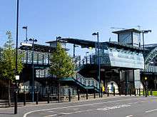
St Peter's Metro station
| St Peter's | |
|---|---|
| Tyne and Wear Metro | |
|
| |
 Exterior of St Peter's station from the west | |
| Location | |
| Place | Monkwearmouth |
| Local authority | City of Sunderland |
| WGS84 | 54°54′40″N 1°23′01″W / 54.9110°N 1.3837°WCoordinates: 54°54′40″N 1°23′01″W / 54.9110°N 1.3837°W |
| Fare zone information | |
| Network One zone | 4 |
| Metro zone | C |
| Original (1979) zone | 57 |
| Station code | STZ |
| Usage | |
| Metro Usage | 0.13[1] million |
| History | |
| Opened | 25 February 2001 (temporary use by Northern Spirit until 16 April 2001) |
| Metro since | 31 March 2002 |
| List of stations | |
St Peter's Metro Station on the Tyne and Wear Metro is the nearest one to the University of Sunderland's St Peter's Campus. The station was built for the Sunderland extension in 2002. It is located at the northern approach viaducts of the Monkwearmouth railway bridge and a short distance south of Monkwearmouth Station Museum.
The southbound platform was completed early and used by National Rail services (operated by Northern Spirit at the time) between 25 February and 16 April 2001, while Sunderland station was being rebuilt for the Metro extension. In order that a four-car DMU could fit the platform, a temporary platform extension was constructed at the northern end.
On Sunday 25 October 2015, Northern Rail ran a special morning service to St. Peter's station, which departed Newcastle Central station at 10:55 and arrived at 11:17. This was due to the Newcastle v Sunderland derby game.
Proximity to Stadium of Light
It is a little known fact that St Peter's station is actually closer to the Stadium of Light, in Sunderland, than Stadium of Light station.
Station art
The station features an installation called White Light [2] created by Ron Haselden. It consists of illuminated ovals embedded into the glass floor, which change in intensity according to the strength of the wind.
See also
- National Glass Centre, nearby attraction
External links
| Wikimedia Commons has media related to St Peter's Metro station. |
- Train times and station information for St Peter's Metro station from Nexus
References
- ↑ [https/www.whatdotheyknow.com/request/automated_announcements_track_ma_2 "Automated Announcements / Track Map / Usage Statistics"] Check
|url=value (help). 2015–2016. Retrieved 29 April 2017. - ↑ "White Light, St Peter's". Art on Transport. Nexus. Archived from the original on 2006-09-27. Retrieved 2007-02-10.
| Preceding station | Tyne and Wear Metro | Following station | ||
|---|---|---|---|---|
towards Airport | Green line | towards South Hylton |