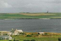
St Magnus Church, Egilsay

St Magnus's Church on Egilsay, one of the Orkney Islands in Scotland, dates back to the 12th century and early Norse times. Although it is a roofless ruin, it is remarkably complete, and is described by Historic Environment Scotland (HES) as second only to St Magnus Cathedral, Kirkwall, as a surviving Norse church in Scotland.[1]
The Orkneyinga saga records that around 1116, Magnus Erlendsson, Earl of Orkney, travelled to the island to resolve a dispute with his rival, Earl Haakon, but Magnus was murdered. In 1136 Bishop William of Orkney sanctified the murdered Earl, who became Saint Magnus, and it is thought that the church was constructed shortly afterwards on the supposed site of the murder.[1] There may have been an earlier church at or near the site before the murder of Magnus.[2]

The bell-tower at the west end of the church forms a prominent landmark, and was originally over 20 metres (66 ft) high.[3] This five-storey round tower is similar to other church towers in Germany and around the North Sea, and still stands about 16 metres (52 ft) tall. A door leads from the tower to the central nave of the church which has external doors to the north and south. The chancel at the east end of the church opens directly from the nave, and housed the altar. It has a barrel-vaulted ceiling under a large upper chamber which could have contained a treasury and sacristy. Both the nave and the chancel originally had steeply pitched roofs.[1][2]
It is maintained by Historic Scotland as an Ancient Monument, and is a Category A listed building.
References
| Wikimedia Commons has media related to St Magnus Church, Egilsay. |
- 1 2 3 "St Magnus Church: History". Historic Environment Scotland. 2016-12-02. Retrieved 2016-12-06.
- 1 2 "Archaeology Notes". Canmore. 1972-10-14. Retrieved 2016-12-06.
- ↑ "St Magnus Church". Historic Environment Scotland: Overview. 2016-12-02. Retrieved 2016-12-06.
Coordinates: 59°09′25″N 2°56′06″W / 59.157°N 2.935°W